http://www.nrlmry.navy.mil/tc_pages/tc_home.html
The invests keep popping,but no meat so far.Lets see what happens with this 96L one east of the Carolinas.
Invest 96L,North Atlantic-Discussions
Moderator: S2k Moderators


Re: Invest 96L,East of Carolinas-Discussions-Analysis & Imagery
QS pass just in shows a broad but closed LLC. One wind barb of up to 30kts just east of the center:
http://manati.orbit.nesdis.noaa.gov/dat ... MBas19.png
http://manati.orbit.nesdis.noaa.gov/dat ... MBas19.png
0 likes
-
cycloneye

- Admin

- Posts: 139083
- Age: 67
- Joined: Thu Oct 10, 2002 10:54 am
- Location: San Juan, Puerto Rico
Re: Invest 96L,East of Carolinas-Discussions-Analysis & Imagery
WHXX01 KWBC 301248
CHGHUR
TROPICAL CYCLONE GUIDANCE MESSAGE
NWS TPC/NATIONAL HURRICANE CENTER MIAMI FL
1248 UTC THU AUG 30 2007
DISCLAIMER...NUMERICAL MODELS ARE SUBJECT TO LARGE ERRORS.
PLEASE REFER TO NHC OFFICIAL FORECASTS FOR TROPICAL CYCLONE
AND SUBTROPICAL CYCLONE INFORMATION.
ATLANTIC OBJECTIVE AIDS FOR
DISTURBANCE INVEST (AL962007) 20070830 1200 UTC
...00 HRS... ...12 HRS... ...24 HRS. .. ...36 HRS...
070830 1200 070831 0000 070831 1200 070901 0000
LAT LON LAT LON LAT LON LAT LON
BAMS 35.7N 70.4W 36.7N 70.9W 37.8N 71.3W 38.5N 70.8W
BAMD 35.7N 70.4W 36.8N 70.6W 38.4N 70.0W 40.5N 67.8W
BAMM 35.7N 70.4W 36.7N 70.9W 38.0N 70.8W 39.5N 69.4W
LBAR 35.7N 70.4W 36.4N 70.2W 37.8N 69.3W 39.9N 67.5W
SHIP 25KTS 29KTS 35KTS 45KTS
DSHP 25KTS 29KTS 35KTS 45KTS
...48 HRS... ...72 HRS... ...96 HRS. .. ..120 HRS...
070901 1200 070902 1200 070903 1200 070904 1200
LAT LON LAT LON LAT LON LAT LON
BAMS 38.8N 69.0W 36.6N 64.1W 33.7N 61.8W 33.4N 60.9W
BAMD 43.2N 63.5W 48.6N 53.5W 53.2N 42.2W 58.1N 27.8W
BAMM 40.9N 65.8W 42.9N 56.3W 43.7N 48.3W 45.5N 39.4W
LBAR 42.9N 64.2W 50.2N 49.9W .0N .0W .0N .0W
SHIP 53KTS 55KTS 51KTS 42KTS
DSHP 53KTS 55KTS 51KTS 42KTS
...INITIAL CONDITIONS...
LATCUR = 35.7N LONCUR = 70.4W DIRCUR = 0DEG SPDCUR = 0KT
LATM12 = 35.3N LONM12 = 70.0W DIRM12 = 321DEG SPDM12 = 3KT
LATM24 = 34.9N LONM24 = 69.6W
WNDCUR = 25KT RMAXWD = 60NM WNDM12 = 25KT
CENPRS = 1011MB OUTPRS = 1013MB OUTRAD = 120NM SDEPTH = D
RD34NE = 0NM RD34SE = 0NM RD34SW = 0NM RD34NW = 0NM
0 likes
-
flwxwatcher
- Category 4

- Posts: 926
- Joined: Wed May 16, 2007 3:35 pm
- Location: Central Florida
Re: Invest 96L,East of Carolinas-Discussions-Analysis & Imagery
Looks like whatever becomes of 96L will be moving NE the next few days
0 likes

-
DanKellFla

- Category 5

- Posts: 1291
- Joined: Fri Mar 17, 2006 12:02 pm
- Location: Lake Worth, Florida
-
storms in NC

- S2K Supporter

- Posts: 2338
- Joined: Thu Jul 28, 2005 2:58 pm
- Location: Wallace,NC 40 miles NE of Wilm
- Contact:
-
Tropics Guy

- Tropical Storm

- Posts: 165
- Age: 61
- Joined: Tue Aug 31, 2004 8:12 pm
- Location: Vero Beach, FL
Re: Invest 96L,East of Carolinas-Discussions-Analysis & Imagery
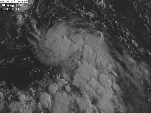
96L looking good on the visible shot, think this will be the invest to make it to TD status first.
TG
TG
0 likes
-
windstorm99

- S2K Supporter
- Posts: 1578
- Age: 46
- Joined: Sat May 26, 2007 8:10 am
- Location: Miami, Florida
- Contact:
Re: Invest 96L,East of Carolinas-Discussions-Analysis & Imagery
Nothing but a problem for the fish. 
0 likes

Re: Invest 96L,East of Carolinas-Discussions-Analysis & Imagery
whenever you get systems that form off North Carolina their ususally NE accellerators. I would bet this will only affect the fish.
0 likes
-
cycloneye
- Admin
- Posts: 139083
- Age: 67
- Joined: Thu Oct 10, 2002 10:54 am
- Location: San Juan, Puerto Rico
Re: Invest 96L,East of Carolinas-Discussions-Analysis & Imagery
You can go and vote in poll in Talking Tropics forum about which invest will be a TD first.
0 likes
-
HouTXmetro

- Category 5
- Posts: 3949
- Joined: Sun Jun 13, 2004 6:00 pm
- Location: District of Columbia, USA
-
storms in NC
- S2K Supporter
- Posts: 2338
- Joined: Thu Jul 28, 2005 2:58 pm
- Location: Wallace,NC 40 miles NE of Wilm
- Contact:
Re:
HouTXmetro wrote:Since the Highs have been so dominant, anyone think this can get pushed back South later in the forecast?
I was thinking the same thing here. With the front coming down could it pull it close to the coast of NC?
Sure would be nice for some rain. TD or TS would be just fine for me.
0 likes
-
storms in NC
- S2K Supporter
- Posts: 2338
- Joined: Thu Jul 28, 2005 2:58 pm
- Location: Wallace,NC 40 miles NE of Wilm
- Contact:
I guess we will just see how weak it really is
AREA FORECAST DISCUSSION
NATIONAL WEATHER SERVICE WILMINGTON NC
940 AM EDT THU AUG 30 2007
LONG TERM /SATURDAY NIGHT THROUGH WEDNESDAY/...
FCST SOUNDINGS SHOW AMPLE MOISTURE LINGERING AND SLIGHT CHANCE
POPS MAY NEED TO BE CARRIED INTO SUNDAY. UNCERTAINTY REMAINS
REGARDING CLOUD COVER AND THE RESULTING AFFECTS ON TEMPERATURES.
ONLY MODEST CAA BEHIND THE FRONT SO BREAKS OF SUN WOULD ONLY LEAD
TO HIGHS A FEW DEGREES COOLER THAN THOSE OF MIDWEEK. NERLY FLOW
STRATUS HOWEVER COULD REALLY KEEP TEMPS DOWN THROUGH THE
AFTERNOON. HAVE GENERALLY FOLLOWED HPC/GFS GUIDANCE WHICH SHOW
TEMPS PRETTY CLOSE TO CLIMO. ANOTHER WILDCARD IS THE
STRENGTH/POSITION OF LOW PRESSURE WELL OFF THE COAST AND ITS
POSSIBLE INFLUENCE ON THE STRENGTH OF THE COLD AIR/DRY AIR
ADVECTION. MON-WED LOOK DRY WITH A POORLY DEFINED HIGH STILL TO
THE NORTH AND VERY WEAK MID LEVEL FLOW.
0 likes

-
Epsilon_Fan

- Category 1

- Posts: 353
- Joined: Fri Jan 13, 2006 1:03 pm
- Location: Charleston, SC
Re: Invest 96L,East of Carolinas-Discussions-Analysis & Imagery
It has good convection and outflow to the southern side. I'd say this was on its way to a TD if it isn't already
0 likes
-
AnnularCane

- S2K Supporter
- Posts: 2634
- Joined: Thu Jun 08, 2006 9:18 am
- Location: Wytheville, VA
Re: Invest 96L,East of Carolinas-Discussions-Analysis & Imagery
Wow, where did this one come from? I didn't even know there was anything there. 
0 likes
Who is online
Users browsing this forum: No registered users and 116 guests