Invest 96L,North Atlantic-Discussions
Moderator: S2k Moderators

Re: Invest 96L,North Atlantic-Discussions-Analysis & Imagery
As evidenced by the recent blow up of convection on the northeast side, it's trying. I've got to admire a system that is trying, especially when it is not threatening any land areas.
0 likes
-
HURAKAN

- Professional-Met

- Posts: 46086
- Age: 37
- Joined: Thu May 20, 2004 4:34 pm
- Location: Key West, FL
- Contact:
Re: Invest 96L,North Atlantic-Discussions-Analysis & Imagery
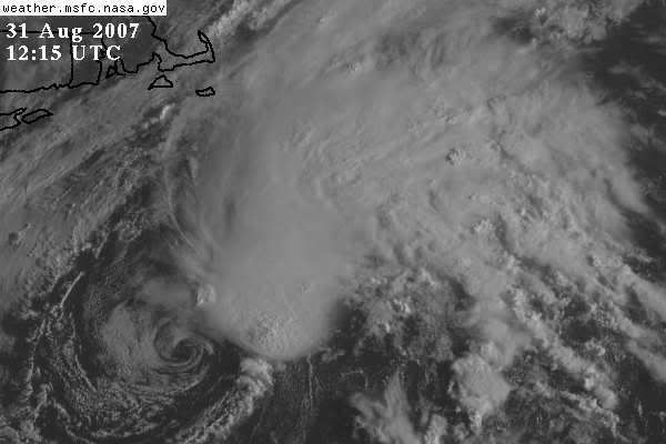
JUST FOR COMPARISON PURPOSES:
Arlene:
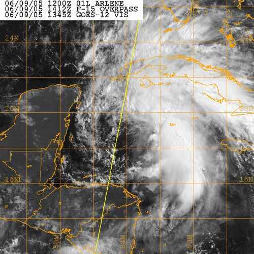
96L:
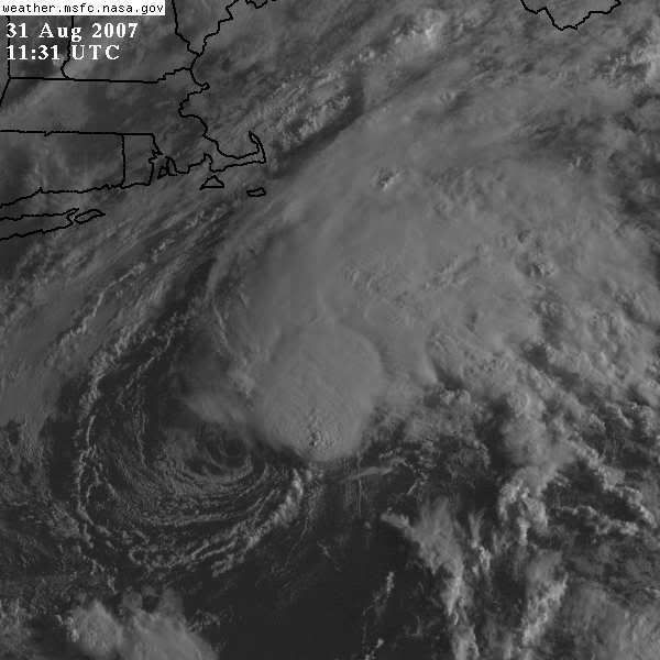
Arlene:
96L:
0 likes

Re: Invest 96L,North Atlantic-Discussions-Analysis & Imagery
481
WHXX01 KWBC 311226
CHGHUR
TROPICAL CYCLONE GUIDANCE MESSAGE
NWS TPC/NATIONAL HURRICANE CENTER MIAMI FL
1226 UTC FRI AUG 31 2007
DISCLAIMER...NUMERICAL MODELS ARE SUBJECT TO LARGE ERRORS.
PLEASE REFER TO NHC OFFICIAL FORECASTS FOR TROPICAL CYCLONE
AND SUBTROPICAL CYCLONE INFORMATION.
ATLANTIC OBJECTIVE AIDS FOR
DISTURBANCE INVEST (AL962007) 20070831 1200 UTC
...00 HRS... ...12 HRS... ...24 HRS. .. ...36 HRS...
070831 1200 070901 0000 070901 1200 070902 0000
LAT LON LAT LON LAT LON LAT LON
BAMS 38.1N 70.5W 39.0N 69.6W 39.1N 67.4W 38.2N 64.1W
BAMD 38.1N 70.5W 40.3N 68.0W 43.3N 63.1W 47.0N 57.9W
BAMM 38.1N 70.5W 39.4N 68.7W 40.7N 65.0W 42.0N 60.0W
LBAR 38.1N 70.5W 39.9N 68.2W 42.4N 64.5W 45.9N 59.0W
SHIP 30KTS 36KTS 47KTS 55KTS
DSHP 30KTS 36KTS 47KTS 55KTS
...48 HRS... ...72 HRS... ...96 HRS. .. ..120 HRS...
070902 1200 070903 1200 070904 1200 070905 1200
LAT LON LAT LON LAT LON LAT LON
BAMS 36.5N 60.7W 33.1N 56.9W 32.9N 55.4W 34.6N 52.1W
BAMD 50.5N 52.8W 57.8N 41.9W 63.8N 24.3W 65.4N 1.2E
BAMM 43.0N 54.9W 43.6N 46.1W 43.7N 37.5W 43.6N 32.0W
LBAR 50.0N 50.8W .0N .0W .0N .0W .0N .0W
SHIP 57KTS 47KTS 43KTS 28KTS
DSHP 53KTS 43KTS 39KTS 24KTS
...INITIAL CONDITIONS...
LATCUR = 38.1N LONCUR = 70.5W DIRCUR = 40DEG SPDCUR = 5KT
LATM12 = 37.2N LONM12 = 70.5W DIRM12 = 329DEG SPDM12 = 7KT
LATM24 = 35.7N LONM24 = 70.4W
WNDCUR = 30KT RMAXWD = 30NM WNDM12 = 25KT
CENPRS = 1003MB OUTPRS = 1010MB OUTRAD = 90NM SDEPTH = M
RD34NE = 0NM RD34SE = 0NM RD34SW = 0NM RD34NW = 0NM
$$
NNNN
No upgrade yet, though winds are up to 30kts and pressure down to 1003mb.
0 likes
-
Matt-hurricanewatcher

- Category 5

- Posts: 11649
- Age: 38
- Joined: Fri Nov 26, 2004 11:09 pm
- Location: Portland,OR
- Contact:
Re: Invest 96L,North Atlantic-Discussions-Analysis & Imagery
Systems like this not being upgraded makes me think that half the system that form in the gulf or western caribbean don't deserve upgrading. Because some of them get less then 1.0t. As far as I'm concerned they are less systems.
0 likes
-
HURAKAN
- Professional-Met
- Posts: 46086
- Age: 37
- Joined: Thu May 20, 2004 4:34 pm
- Location: Key West, FL
- Contact:
Re: Invest 96L,North Atlantic-Discussions-Analysis & Imagery
Matt-hurricanewatcher wrote:Systems like this not being upgraded makes me think that half the system that form in the gulf or western caribbean don't deserve upgrading. Because some of them get less then 1.0t. As far as I'm concerned they are less systems.
You and me should take over the NHC!!!!
0 likes
-
Matt-hurricanewatcher
- Category 5
- Posts: 11649
- Age: 38
- Joined: Fri Nov 26, 2004 11:09 pm
- Location: Portland,OR
- Contact:
Re: Invest 96L,North Atlantic-Discussions-Analysis & Imagery
HURAKAN wrote:Matt-hurricanewatcher wrote:Systems like this not being upgraded makes me think that half the system that form in the gulf or western caribbean don't deserve upgrading. Because some of them get less then 1.0t. As far as I'm concerned they are less systems.
You and me should take over the NHC!!!!
This thing has a well defined LLC with convection bursting over it. Not a bad system better then 30-40 percent of the systems in the Gulf. Possibly more. I'm sorry I'm this way, but I just like to have a standard. It is hard for me to see one system get upgraded that looks like nothing then have something "stronger" then it not being upgraded.
I understand that they upgrade a system because of land. But this hurts seasonal forecast some what. When there is so much pressure on it these days.
0 likes
-
Lowpressure

- S2K Supporter

- Posts: 2032
- Age: 57
- Joined: Sun Sep 14, 2003 9:17 am
- Location: Charlotte, North Carolina
-
HURAKAN
- Professional-Met
- Posts: 46086
- Age: 37
- Joined: Thu May 20, 2004 4:34 pm
- Location: Key West, FL
- Contact:
Re:
Derek Ortt wrote:is it warm core though?
Up to now the NHC has only indicated the possibility of tropical development, not subtropical. This may indicate they think the system is tropical.

0 likes

Re: Re:
Lowpressure wrote:Derek Ortt wrote:is it warm core though?
Was Chantal?
Yes, Chantal was warm-core, otherwise it wouldn't have been called a tropical storm.
As for 96L... 06Z GFS suggests borderline cold-core.
0 likes

-
DESTRUCTION5

- Category 5
- Posts: 4391
- Age: 42
- Joined: Wed Sep 03, 2003 11:25 am
- Location: Stuart, FL
Re: Invest 96L,North Atlantic-Discussions-Analysis & Imagery
It looks extratropical transition may be already beginning, on satellite imagery. The LLC is being more removed and stretched out, from convection to the east, and the convection itself is beginning to weaken. I doubt NHC will bother with this one anymore.
0 likes
-
Hurricaneman

- Category 5
- Posts: 7281
- Age: 43
- Joined: Tue Aug 31, 2004 3:24 pm
- Location: central florida
Re: Invest 96L,North Atlantic-Discussions-Analysis & Imagery
This will probably get named in January when they do a possible reanalysis
0 likes
-
CrazyC83
- Professional-Met
- Posts: 33393
- Joined: Tue Mar 07, 2006 11:57 pm
- Location: Deep South, for the first time!
http://manati.orbit.nesdis.noaa.gov/dat ... MBas19.png
Center is around 37.7°N 71.5°W according to QuikSCAT.
Center is around 37.7°N 71.5°W according to QuikSCAT.
0 likes
Who is online
Users browsing this forum: No registered users and 117 guests