Invest 90L SE GOM: Discussions & Images
Moderator: S2k Moderators
-
lrak

- S2K Supporter

- Posts: 1770
- Age: 57
- Joined: Thu Jun 21, 2007 2:48 pm
- Location: Corpus Christi, TX
Re: Invest 90L SE GOM: Discussions & Images
your teasing me now Mr. Waxman57. A nice East fetch developing for the Texas coast. drool 
0 likes


Re: Invest 90L SE GOM: Discussions & Images
I will start off by saying, it "ain't" pretty; but this system has a low level signature and has a chance to pop before the coast IMO. GOM SSTs are in the mid/upper 80s in that area and shear should contiue to relax as it heas toward the Texas coast.
25.2N 93W
25.2N 93W
0 likes
-
Lowpressure

- S2K Supporter
- Posts: 2032
- Age: 57
- Joined: Sun Sep 14, 2003 9:17 am
- Location: Charlotte, North Carolina
Re: Invest 90L SE GOM: Discussions & Images
All I see coming from this appears to be something we can not buy, a rainmaker. It could do a little something as it approaches Texas, but I really do not see it here.
0 likes

Re: Invest 90L SE GOM: Discussions & Images
Well the ULL over the BOC sure did fill overnite, so I guess it has a better chance of some development.
http://www.ssd.noaa.gov/goes/east/gmex/loop-wv.html
low level vorticity has increased
http://cimss.ssec.wisc.edu/tropic/real- ... 8vor4.html
Shear has decreased a lot
http://cimss.ssec.wisc.edu/tropic/real- ... g8sht.html
Pressures still high and not many T-storms. But still invest worthy IMHO.
http://www.ssd.noaa.gov/goes/east/gmex/loop-wv.html
low level vorticity has increased
http://cimss.ssec.wisc.edu/tropic/real- ... 8vor4.html
Shear has decreased a lot
http://cimss.ssec.wisc.edu/tropic/real- ... g8sht.html
Pressures still high and not many T-storms. But still invest worthy IMHO.
0 likes
-
Stormcenter
- S2K Supporter
- Posts: 6617
- Joined: Wed Sep 03, 2003 11:27 am
- Location: Houston, TX
Re: Invest 90L SE GOM: Discussions & Images
Hmmmmmmm something very very interesting "may" be brewing in the GOM this
Monday morning.
http://www.ssd.noaa.gov/goes/east/gmex/loop-vis.html
http://www.ssd.noaa.gov/goes/east/gmex/loop-avn.html
Monday morning.
http://www.ssd.noaa.gov/goes/east/gmex/loop-vis.html
http://www.ssd.noaa.gov/goes/east/gmex/loop-avn.html
0 likes
-
mattpetre
- Category 2

- Posts: 510
- Age: 52
- Joined: Mon Sep 19, 2005 3:20 pm
- Location: Missouri City,TX & Galleria
- Contact:
Re: Invest 90L SE GOM: Discussions & Images
Looks to me to be closer to 24N 91W for any low level happenings... but probably is currently too weak... I'm still predicting a depression by end of today Central Time.
0 likes

Re: Invest 90L SE GOM: Discussions & Images
Matt, what's making you see a depression in a day's time here? I think any development is dicey, but what's going to make this thing pop in twelve hours? Just wondering......
0 likes

Re: Invest 90L SE GOM: Discussions & Images
TWC isn't saying anything about this...just basically looking over it saying the gulf remains quiet...go figure 
0 likes
-
Stormcenter
- S2K Supporter
- Posts: 6617
- Joined: Wed Sep 03, 2003 11:27 am
- Location: Houston, TX
Re: Invest 90L SE GOM: Discussions & Images
dtrain44 wrote:Matt, what's making you see a depression in a day's time here? I think any development is dicey, but what's going to make this thing pop in twelve hours? Just wondering......
It looks like it's popping already this morning.
Unfortunately things in the GOM have tendency to
"pop" in no time. I hope I wrong and nothing forms.
http://www.ssd.noaa.gov/goes/east/gmex/loop-avn.html
0 likes
-
Portastorm

- Storm2k Moderator

- Posts: 9787
- Age: 61
- Joined: Fri Jul 11, 2003 9:16 am
- Location: South Austin, TX
- Contact:
Re: Invest 90L SE GOM: Discussions & Images
wxman57 wrote:Hang on a second, it looks like Bones went through a worm hole in his shuttlecraft. He'll be making a statement within the next 24 hours on this system.
I dunno Wxman57 ... from the looks of it this morning ... Bones' announcement may be a bit delayed!
0 likes
-
mattpetre
- Category 2
- Posts: 510
- Age: 52
- Joined: Mon Sep 19, 2005 3:20 pm
- Location: Missouri City,TX & Galleria
- Contact:
Re: Invest 90L SE GOM: Discussions & Images
dtrain44 wrote:Matt, what's making you see a depression in a day's time here? I think any development is dicey, but what's going to make this thing pop in twelve hours? Just wondering......
Please don't take my words too strongly, I've been bullish on this thing ever since it popped on the end of the front that passed through. I made a prediction that it would be an invest yesterday and a depression today back on saturday, so since it became an invest... i'm sticking to my guns on the depression, but other than some decent convection I must admit it really doesn't look that great right now. Just sticking to my guns till there is no chance that I might have been right. From a purely meteorological perspective I only give this about a 20% chance of becoming a depression ever now. But my gut gives it about a 90% chance...
Shear does appear to be reducing...
0 likes
Re: Invest 90L SE GOM: Discussions & Images
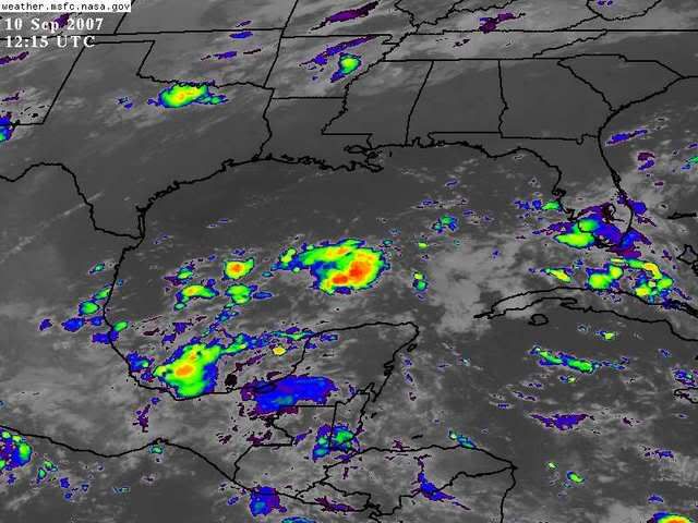
weak LLC at 25.5 and 93.0.... moving nw slowly... if an LLC were to redevelop more off to the SE in the general area of the main convection (24.0 and 91.0) things could get very interesting in the GOM...
weak LLC obvious on the GOES vis loop..
http://weather.msfc.nasa.gov/GOES/goeseastconus.html
weak LLC obvious on the GOES vis loop..
http://weather.msfc.nasa.gov/GOES/goeseastconus.html
0 likes
-
mattpetre
- Category 2
- Posts: 510
- Age: 52
- Joined: Mon Sep 19, 2005 3:20 pm
- Location: Missouri City,TX & Galleria
- Contact:
Re: Invest 90L SE GOM: Discussions & Images
I may be seeing something more in the mid levels, but it looks like there is some sort of circulation just to the SW of the big blog... anyone else see it?
0 likes
Re: Invest 90L SE GOM: Discussions & Images
Fair enough. Beats the heck out of "ALIVE! DEAD! ALIVE! NEXT! CAT 5! TOLD YOU!" type predictions.... 
There certainly is still a chance that you'll turn out right.....
There certainly is still a chance that you'll turn out right.....
0 likes
Re: Invest 90L SE GOM: Discussions & Images
I can see a little spin, but it will probably be a lot easier to see once we've had some daylight behind us. There aren't enough images in the loop for me to really see a good circulation....
0 likes
Re: Invest 90L SE GOM: Discussions & Images
I can see something there, at about 23W, 91N. I "Bones" does not show up in 24hrs I think the shear monster will be gone after that.
0 likes
-
jasons2k

- Storm2k Executive

- Posts: 8076
- Age: 50
- Joined: Wed Jul 06, 2005 12:32 pm
- Location: The Woodlands, TX
Re: Invest 90L SE GOM: Discussions & Images
This is the take from Jeff Lindner, a local pro-met:
Area of disturbed weather over the Gulf of Mexico is tied to an upper air low over the southern Gulf and surface low pressure trough. Although weak development is shown by both the CMC and NAM neither one of these models are trusted in tropical forecasting. Will not discount the potential given a somewhat similar setup to TS Erin with any development likely being on the vented east side of the upper air low as it moves westward. Anything that happens will be very slow and likely heavily sheared.
A surface trough axis extends from S FL to the southern Gulf of Mexico with scattered thunderstorms along this line. An upper air low is noted over the southern Gulf of Mexico moving westward. Although thunderstorms are limited and shear is strong there may be a chance at some development as the upper air low moves westward allowing venting of the surface features on the east side of the low. This is a similar setup to TS Erin, TS Frances, and TS Allison where a weak tropical system forms east of the upper low in a usually heavily sheared environment. The CMC and NAM are most aggressive with any formations with the GFS maintaining more of an open wave or trough axis. Approach of weak frontal boundary along the Gulf coast may help tighten the pressure gradient over the northern Gulf later this week.
0 likes
-
StormWarning1
- Category 1

- Posts: 254
- Joined: Sun Jul 10, 2005 9:29 pm
- Location: Nashville TN
Who is online
Users browsing this forum: No registered users and 129 guests