TD INGRID: Discussions & Images - Last Advisory
Moderator: S2k Moderators
-
O Town
- S2K Supporter

- Posts: 5203
- Age: 50
- Joined: Wed Sep 07, 2005 9:37 pm
- Location: Orlando, Florida 28°35'35"N 81°22'55"W
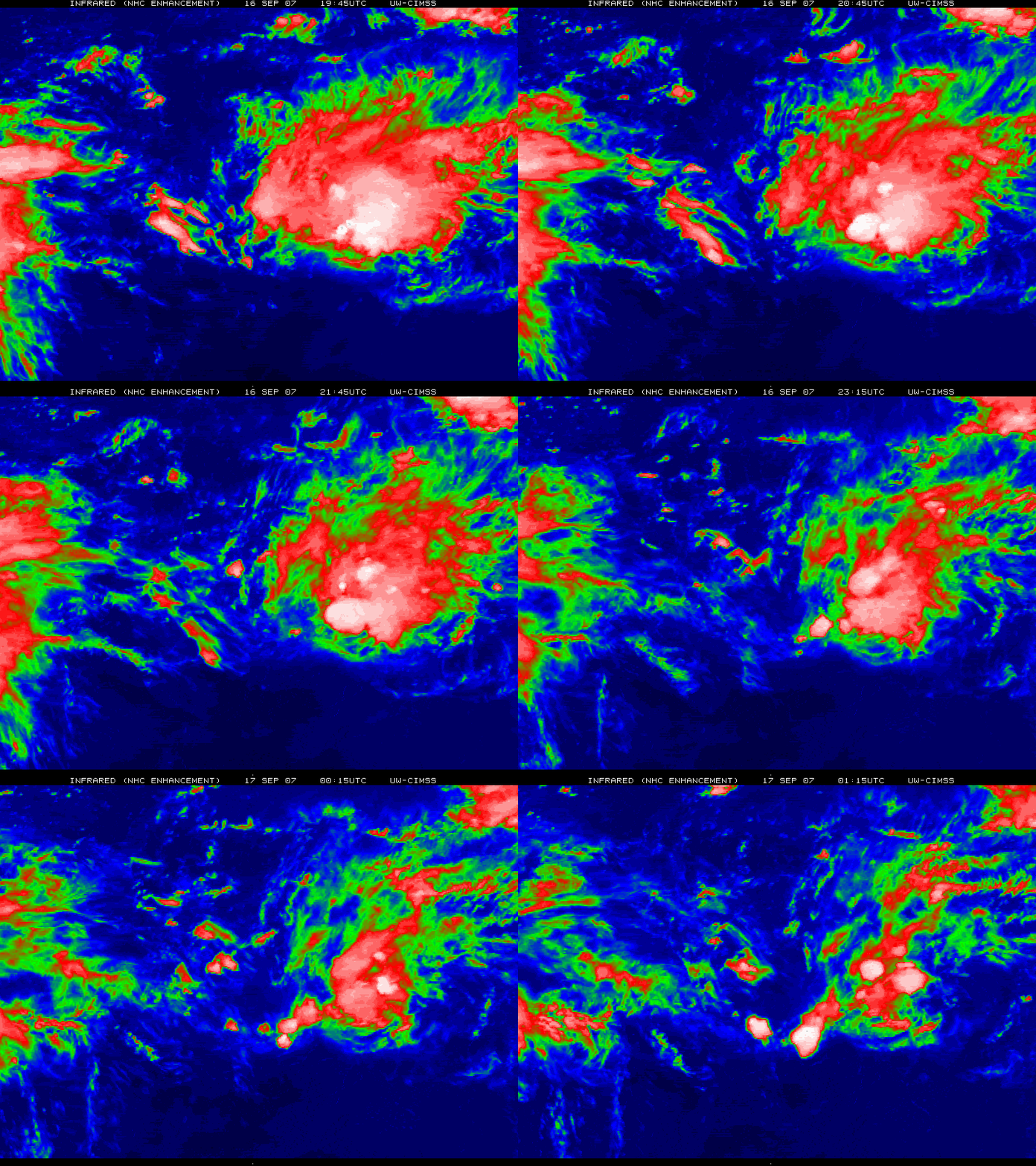
I have noticed that Ingrid seems to go from looking good for 6 or so hours to looking bad for the next 6 hours. It seems to have been that way since her beginning. Its hard to tell what she will do, and it seems during the night times when you would thing she would look better she starts to look ragid, and then during the daytime she looks better. I don't know what all that means but it seems she can't seem to hang on to her convection for longer than a brief period of time. Just when I think she has gone poof a new ball of convection seems to refire to the north. Just like a woman, can't seem to make up her mind. 


Last edited by O Town on Sun Sep 16, 2007 10:20 pm, edited 1 time in total.
0 likes
-
JonathanBelles
- Professional-Met

- Posts: 11430
- Age: 33
- Joined: Sat Dec 24, 2005 9:00 pm
- Location: School: Florida State University (Tallahassee, FL) Home: St. Petersburg, Florida
- Contact:
Re: Tropical Depression INGRID: Discussions & Images
Although wind shear can occur at anytime in the tropics, it is somewhat puzzling to me that the conditions down there are so hostile for mid September and especially when conditions were forecast to be very favorable for an active season.
The discussions from the NHC on Ingrid are almost like discussions you might hear from them with a storm that forms during an odd time of the year when conditions are very unfavorable.
It will be interesting to see if this pattern continues to persist.
The discussions from the NHC on Ingrid are almost like discussions you might hear from them with a storm that forms during an odd time of the year when conditions are very unfavorable.
It will be interesting to see if this pattern continues to persist.
0 likes
- vbhoutex
- Storm2k Executive

- Posts: 28974
- Age: 72
- Joined: Wed Oct 09, 2002 11:31 pm
- Location: Spring Branch area, Houston, TX
- Contact:
Re:
'CaneFreak wrote:The recon plane is still out there...there's the government for you. I guess they figured, "why not?" Lou, you need to be home for any reason, "no." Tom, you need to be home for some reason, "no." "OH, what the heck, this is government $. Lets fly around in the leftover thunderstorms. Does that sound good?" *Everyone in unison: "YEAH".
The plane is out there on a research mission. It wasn't sent specifically for Ingrid or at least that is how I understood the discussion. They decided to check out Ingrid to see if they could find a definite closed circulation and determine an intensity.
0 likes
Thanks, I was about to say that they were on a research flight as was indicated yesterday in this thread.
Where are those who so vehemently insisted that Ingrid would overcome the shear that all the Pro Mets and the NHC said she would encounter? Seems a little quiet.
On to the next one and we can all almost unanimously agree now.
Where are those who so vehemently insisted that Ingrid would overcome the shear that all the Pro Mets and the NHC said she would encounter? Seems a little quiet.
On to the next one and we can all almost unanimously agree now.
0 likes
- 'CaneFreak
- Category 5

- Posts: 1475
- Joined: Mon Jun 05, 2006 10:50 am
- Location: New Bern, NC
Re:
fci wrote:Thanks, I was about to say that they were on a research flight as was indicated yesterday in this thread.
Where are those who so vehemently insisted that Ingrid would overcome the shear that all the Pro Mets and the NHC said she would encounter? Seems a little quiet.
On to the next one and we can all almost unanimously agree now.
Yep, I agree. I have been saying this for days on end. But who listens to me? Or the pro-mets for that matter? That is what they are here for!!!! They have gone through the schooling and all to become who they are and they are at our disposal and so many here dont understand that and tend to disagree with anything and EVERYTHING they say. Now there are some here just for the information and they tend to thank the pro-mets. I am here to learn because I am going to become a tropical weather MET one day and hopefully work at the NHC or TPC one day. If you are a pro-met and would like to PM me about what I need to be doing right now as far as schooling for the future, that would be excellent. I think I am on the right track already, but some advice is always good. Off of my soap box...but really...listen to your pro-mets and thank them for the time they spend so that you get accurate up to the hour information. They are taking their down-time to share info with you and most of you dont listen to them. They WANT you to learn. But you have to listen. Anyways, thanks to all the Pro-mets out there for your time and effort. I CERTAINLY APPRECIATE IT very much.
0 likes
- MGC
- S2K Supporter

- Posts: 5792
- Joined: Sun Mar 23, 2003 9:05 pm
- Location: Pass Christian MS, or what is left.
Re: Tropical Depression INGRID: Discussions & Images
Ingrid is likely just a remnant low devoid of convection. Unless convection refires overnight I would think the NHC will stick a fork in it soon. Shear: TC killer......MGC
0 likes
-
bwhorton2007
- Tropical Storm

- Posts: 115
- Joined: Thu Sep 13, 2007 11:17 pm
Re: Tropical Depression INGRID: Discussions & Images
Yes anyone with any sense can see that this thing is gone just by looking at sat photos.they don't need a pro to tell them this.
i have no metoerology knowledge yet i don't need it to see that Ingrid is gone.
i have no metoerology knowledge yet i don't need it to see that Ingrid is gone.
0 likes
-
Derek Ortt
-
curtadams
- S2K Supporter

- Posts: 1118
- Joined: Sun Aug 28, 2005 7:57 pm
- Location: Orange, California
- Contact:
Re: Re:
wxman57 wrote:fasterdisaster wrote:I definitely wouldn't stop advisories yet. If it still looks this crappy at 5 AM then that should be the last advisory.
But would you START advisories on something so pitiful that was moving into 30+ kt shear?
By the standards the NHC uses to upgrade, this should be Tropical Low Ingrid.
0 likes
- Matt-hurricanewatcher
- Category 5

- Posts: 11649
- Age: 38
- Joined: Fri Nov 26, 2004 11:09 pm
- Location: Portland,OR
- Contact:
Re: Tropical Depression INGRID: Discussions & Images
The latest quickscat still shows a closed LLC, but very weak.
0 likes
- Matt-hurricanewatcher
- Category 5

- Posts: 11649
- Age: 38
- Joined: Fri Nov 26, 2004 11:09 pm
- Location: Portland,OR
- Contact:
Re: Tropical Depression INGRID: Discussions & Images
Broad LLC with strong shear. I hate to say it but if they write another advisory on this, they should start advisorys on subtropical storm jerry southwest of the azores. That is my option.
0 likes
- wxman57
- Moderator-Pro Met

- Posts: 22482
- Age: 66
- Joined: Sat Jun 21, 2003 8:06 pm
- Location: Houston, TX (southwest)
Re: TD INGRID: Discussions & Images - Last Advisory
Bones' proclamation of the death of Ingrid applies only to the current state of the tropical cyclone. It does not preclude the possibility of resurrection at some later date. Ingrid remains a moderate tropical wave and will have the same potential for development as any other tropical wave once it moves into an environment more favorable for development. Your mileage may vary...


0 likes
- Evil Jeremy
- S2K Supporter

- Posts: 5459
- Age: 30
- Joined: Mon Apr 10, 2006 2:10 pm
- Location: Los Angeles, CA
Re: TD INGRID: Discussions & Images - Last Advisory
Who thinks that regeneration of Ingrid is possible down the road?
0 likes
-
Coredesat
-
curtadams
- S2K Supporter

- Posts: 1118
- Joined: Sun Aug 28, 2005 7:57 pm
- Location: Orange, California
- Contact:
Re: TD INGRID: Discussions & Images - Last Advisory
It's kind of interesting that so many people want to "stick a fork in it". If a wave had formed a large closed low just off the windwards but was under moderately high shear expected to drop in a couple of days there would be a dozen pages of heated discussion. But, since it was a TC for a while beforehand, most want to drop it.
0 likes
-
miamicanes177
- Category 5

- Posts: 1131
- Joined: Tue Aug 01, 2006 10:53 pm
Re: TD INGRID: Discussions & Images - Last Advisory
I 100% agree and believe as you do that this should be closely monitored for further development. 06z GFDL says watchout!wxman57 wrote:Bones' proclamation of the death of Ingrid applies only to the current state of the tropical cyclone. It does not preclude the possibility of resurrection at some later date. Ingrid remains a moderate tropical wave and will have the same potential for development as any other tropical wave once it moves into an environment more favorable for development. Your mileage may vary...
0 likes
- Gustywind
- Category 5

- Posts: 12334
- Joined: Mon Sep 03, 2007 7:29 am
- Location: Baie-Mahault, GUADELOUPE
AT 500 AM AST...DISSIPATING TROPICAL DEPRESSION INGRID WAS LOCATED
NEAR 17.5 NORTH...60.0 WEST...MOVING SLOWLY WEST NEAR 9 MPH. INGRID
REMAINS UNDER A VERY HOSTILE UPPER LEVEL WIND ENVIRONMENT AND HAS SO
FAR CONTINUED TO WEAKEN DUE TO WESTERLY SHEAR. BASED ON THE LATEST
TROPICAL CYCLONE FORECAST...INGRID OR ITS REMNANTS IS EXPECTED TO
MOVE SLOWLY NORTHWESTWARD OVER THE NEXT FEW DAYS...AND PASS NORTHEAST
OF THE LEEWARD ISLANDS TODAY THROUGH TUESDAY. THIS WILL ACT TO FURTHER
WEAKEN THE LOCAL WIND FLOW ACROSS THE REGION.
0 likes
- Gustywind
- Category 5

- Posts: 12334
- Joined: Mon Sep 03, 2007 7:29 am
- Location: Baie-Mahault, GUADELOUPE
Re:
Gustywind wrote:AT 500 AM AST...DISSIPATING TROPICAL DEPRESSION INGRID WAS LOCATED
NEAR 17.5 NORTH...60.0 WEST...MOVING SLOWLY WEST NEAR 9 MPH. INGRID
REMAINS UNDER A VERY HOSTILE UPPER LEVEL WIND ENVIRONMENT AND HAS SO
FAR CONTINUED TO WEAKEN DUE TO WESTERLY SHEAR. BASED ON THE LATEST
TROPICAL CYCLONE FORECAST...INGRID OR ITS REMNANTS IS EXPECTED TO
MOVE SLOWLY NORTHWESTWARD OVER THE NEXT FEW DAYS...AND PASS NORTHEAST
OF THE LEEWARD ISLANDS TODAY THROUGH TUESDAY. THIS WILL ACT TO FURTHER
WEAKEN THE LOCAL WIND FLOW ACROSS THE REGION.
.....from 000FXCA62 TJSJ 170947 CCAAFDSJU AREA FORECASTDISCUSSION...CORRECTED
NATIONAL WEATHER SERVICE SAN JUAN PR
544 AM AST MON SEP 17 2007
0 likes
Who is online
Users browsing this forum: No registered users and 114 guests
