
I would also add that the 0Z EURO though does not initialize this than more than a low takes into the upper Texas coast before diving it back down into the WGOM and eventually Brownsville......looks plausible with a building high over Texas......
The key with this is will the upper air dynamics going to let this develope in the coming days.....
Tropical Depression LORENZO: Global & hurricane Models
Moderator: S2k Moderators
-
Ed Mahmoud
Re:
HouTXmetro wrote:I'f Im reading this correct is that (GFS) 66 knots at landfall in Freeport?
I think the 66 knots is the SHIPS, the decay SHIPS would be more representative, as this will cross land.
And between you and me, this just doesn't look right to develop that much. Too strung out. But we need the rain, so I hope it comes in a persistently weak form to my house.
0 likes
Re: Invest 94L: Global & BAM Models
What concerns me is the guidance suggesting a SW motion after hitting the coast.....timing would crucial as a stall could happen as the high builds in and starts it moving the other direction....
0 likes
-
Ed Mahmoud
Re: Invest 94L: Global & BAM Models
The European Community barely has a surface feature, but does have a 500 mb inverted trough.

Edited "doe shave" to "does have"
Edited "doe shave" to "does have"
0 likes
-
Extremeweatherguy

- Category 5

- Posts: 11095
- Joined: Mon Oct 10, 2005 8:13 pm
- Location: Houston, TX
-
HouTXmetro

- Category 5
- Posts: 3949
- Joined: Sun Jun 13, 2004 6:00 pm
- Location: District of Columbia, USA
-
Extremeweatherguy
- Category 5
- Posts: 11095
- Joined: Mon Oct 10, 2005 8:13 pm
- Location: Houston, TX
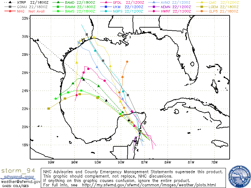
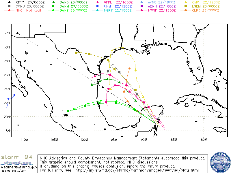
It will all have to do with timing. The slower this system goes, the more likely it is to stall or meander in the western GOM...whereas the faster it goes, the more likely it will be to move into the TX/LA coast. ATM, the model consensus would be for this system to approach or reach the upper TX coast before turning back W or S. The CMC, NOGAPS and GFS (as well as the CONU) scenario are probably the worst case scenario for the Houston metro right now and would likely mean lots of rainfall.
0 likes

Re: Invest 94L: Global & BAM Models
Seems like insane track for late september...I wonder if this could portend a stall in BOC. Who knows. A slow mover in the SW Gulf seems much more plausible at this time of year...waiting for a front to kick it North or Northeast.
0 likes
-
Extremeweatherguy
- Category 5
- Posts: 11095
- Joined: Mon Oct 10, 2005 8:13 pm
- Location: Houston, TX
The 18z GFS is not really developing the low, but it does shoot a pretty large batch of moisture NW toward TX by Tuesday. Beyond Tuesday it then tries to develop some kind of low in the BOC, but it doesn't look too impressive. One thing that does stand out is the slower movement of the moisture though. If something does decide to develop, then it looks like (according to this run) that the system might have an extra 12-18 hours over water.
0 likes
-
Tampa Bay Hurricane

- Category 5
- Posts: 5594
- Age: 36
- Joined: Fri Jul 22, 2005 7:54 pm
- Location: St. Petersburg, FL
-
HURAKAN

- Professional-Met

- Posts: 46086
- Age: 37
- Joined: Thu May 20, 2004 4:34 pm
- Location: Key West, FL
- Contact:
257
WHXX01 KWBC 230044
CHGHUR
TROPICAL CYCLONE GUIDANCE MESSAGE
NWS TPC/NATIONAL HURRICANE CENTER MIAMI FL
0044 UTC SUN SEP 23 2007
DISCLAIMER...NUMERICAL MODELS ARE SUBJECT TO LARGE ERRORS.
PLEASE REFER TO NHC OFFICIAL FORECASTS FOR TROPICAL CYCLONE
AND SUBTROPICAL CYCLONE INFORMATION.
ATLANTIC OBJECTIVE AIDS FOR
DISTURBANCE INVEST (AL942007) 20070923 0000 UTC
...00 HRS... ...12 HRS... ...24 HRS. .. ...36 HRS...
070923 0000 070923 1200 070924 0000 070924 1200
LAT LON LAT LON LAT LON LAT LON
BAMS 19.0N 88.0W 20.1N 89.9W 21.1N 91.6W 21.8N 93.2W
BAMD 19.0N 88.0W 20.6N 89.6W 22.3N 91.4W 23.8N 92.9W
BAMM 19.0N 88.0W 20.0N 89.8W 20.9N 91.5W 21.6N 93.1W
LBAR 19.0N 88.0W 20.4N 89.9W 22.2N 91.9W 24.1N 94.0W
SHIP 25KTS 28KTS 34KTS 39KTS
DSHP 25KTS 30KTS 35KTS 40KTS
...48 HRS... ...72 HRS... ...96 HRS. .. ..120 HRS...
070925 0000 070926 0000 070927 0000 070928 0000
LAT LON LAT LON LAT LON LAT LON
BAMS 22.2N 94.6W 22.3N 97.2W 21.9N 99.3W 21.1N 101.7W
BAMD 24.9N 94.1W 25.4N 96.1W 25.1N 97.3W 24.6N 98.7W
BAMM 22.0N 94.6W 21.9N 97.4W 21.5N 99.8W 20.8N 102.7W
LBAR 25.9N 95.3W 29.5N 96.9W 32.1N 94.8W 32.3N 89.6W
SHIP 45KTS 53KTS 54KTS 51KTS
DSHP 46KTS 54KTS 32KTS 27KTS
...INITIAL CONDITIONS...
LATCUR = 19.0N LONCUR = 88.0W DIRCUR = 300DEG SPDCUR = 11KT
LATM12 = 17.7N LONM12 = 85.8W DIRM12 = 301DEG SPDM12 = 10KT
LATM24 = 16.7N LONM24 = 84.2W
WNDCUR = 25KT RMAXWD = 50NM WNDM12 = 25KT
CENPRS = 1010MB OUTPRS = 1012MB OUTRAD = 125NM SDEPTH = D
RD34NE = 0NM RD34SE = 0NM RD34SW = 0NM RD34NW = 0NM
$$
NNNN
0 likes
-
Ed Mahmoud
Re: Invest 94L: Global & BAM Models
How does Decay SHIPS have a stronger storm than the regular SHIPS?
0 likes
-
Extremeweatherguy
- Category 5
- Posts: 11095
- Joined: Mon Oct 10, 2005 8:13 pm
- Location: Houston, TX
Re: Invest 94L: Global & BAM Models
here is my opinion, for what its worth(NOT MUCH)...If this is to make it to land in the current forecast period say 4-5 days...it will be northern mexico. More likely...we are just going to have some distrubed weather stall out in the BOC for a few days and may, eventually, form something else all together, that isnt necessarily mexico bound. I dont think the full story of 94L will really be told until late in the week. Some of the energy will continue to stream north into the gulf coast. That isnt a forecast for something to happen , just saying that it will probably be late week still sitting in the BOC. AND if you look at GFS upper levels...high pressure is actually progged over the BOC during the mid to late week time frame which would create a conducive environment for strengthening. Take home message...this has a lot more potential than just some rain for SW LA...esp if it can sit in the bay long enough.
0 likes
-
Stormcenter
- S2K Supporter

- Posts: 6617
- Joined: Wed Sep 03, 2003 11:27 am
- Location: Houston, TX


-
attallaman
Re: Invest 94L: Global & BAM Models
Does that map show one model coming towards Mississippi? If so how reliable is that model?TampaFl wrote:From SFWMD:
0 likes
-
JonathanBelles
- Professional-Met
- Posts: 11430
- Age: 33
- Joined: Sat Dec 24, 2005 9:00 pm
- Location: School: Florida State University (Tallahassee, FL) Home: St. Petersburg, Florida
- Contact:
Re: Invest 94L: Global & BAM Models
attallaman wrote:Does that map show one model coming towards Mississippi? If so how reliable is that model?TampaFl wrote:From SFWMD:
image omitted
That models is the climo model, it goes where storms in the past have gone.
0 likes
-
americanrebel

- Category 1

- Posts: 399
- Age: 47
- Joined: Tue Sep 18, 2007 3:42 pm
- Location: Intracoastal City, La.
Who is online
Users browsing this forum: No registered users and 68 guests