INVEST 91L : East of Lesser Antilles : Gone from NRL
Moderator: S2k Moderators
- HurricaneMaster_PR
- Category 2

- Posts: 795
- Joined: Tue Jul 22, 2003 6:23 pm
- Location: San Juan, Puerto Rico
Re: INVEST 91L : East of Lesser Antilles : Discussions & Images
Thunder44 wrote:msbee wrote:I'm heading to Barbados on Monday.
Think I am going to run into trouble with this system?
The upper-level trof ahead of it, should re-curve this system out to sea, over the next few days.
I hope so. I don't want to have to fly through it either
0 likes
Re: INVEST 91L : East of Lesser Antilles : Discussions & Images
Sanibel wrote:I guess the Sanibel guarantee of formation came through after all. After being put through the wringer. I would guess this should recurve, right?
I have to take a european relative to Disney World. I won't have access for a few days.
After living in Orlando for years, I understand the way you phrased that..."have to take..." I finally would just give them the car with the keys to the house and say, Have fun!
0 likes
- Gustywind
- Category 5

- Posts: 12334
- Joined: Mon Sep 03, 2007 7:29 am
- Location: Baie-Mahault, GUADELOUPE
Atlantic Tropical Weather Discussion
--------------------------------------------------------------------------------
000
AXNT20 KNHC 061825
TWDAT
TROPICAL WEATHER DISCUSSION
NWS TPC/NATIONAL HURRICANE CENTER MIAMI FL
205 PM EDT SAT OCT 06 2007
TROPICAL WEATHER DISCUSSION FOR NORTH AMERICA...CENTRAL
AMERICA...THE GULF OF MEXICO...THE CARIBBEAN SEA...NORTHERN
SECTIONS OF SOUTH AMERICA...AND THE ATLANTIC OCEAN TO THE
AFRICAN COAST FROM THE EQUATOR TO 32N. THE FOLLOWING INFORMATION
IS BASED ON SATELLITE IMAGERY...METEOROLOGICAL ANALYSIS...
WEATHER OBSERVATIONS...AND RADAR.
BASED ON 1200 UTC SURFACE ANALYSIS AND SATELLITE IMAGERY
THROUGH 1715 UTC.
...TROPICAL WAVES...
TROPICAL WAVE IS IN THE CENTRAL ATLANTIC ALONG 50W S OF 20N
MOVING W 10 KT. A 1009 MB LOW IS ALONG THE WAVE AXIS NEAR
14.5N. THE INTERACTION BETWEEN THIS WAVE AND DIFFLUENCE ALOFT
TO THE E OF AN UPPER TROUGH HAS CAUSED CONVECTION TO FLARE UP
ALONG AND TO THE E OF THE WAVE/LOW FROM 10N-20N BETWEEN
46W-51W.
SLOW DEVELOPMENT IS POSSIBLE DURING THE NEXT 24 HOURS DESPITE UNFAVORABLE WLY UPPER LEVEL
WINDS.
0 likes
- cycloneye
- Admin

- Posts: 139122
- Age: 67
- Joined: Thu Oct 10, 2002 10:54 am
- Location: San Juan, Puerto Rico
Re: INVEST 91L : Models Thread
WHXX01 KWBC 061828
CHGHUR
TROPICAL CYCLONE GUIDANCE MESSAGE
NWS TPC/NATIONAL HURRICANE CENTER MIAMI FL
1828 UTC SAT OCT 6 2007
DISCLAIMER...NUMERICAL MODELS ARE SUBJECT TO LARGE ERRORS.
PLEASE REFER TO NHC OFFICIAL FORECASTS FOR TROPICAL CYCLONE
AND SUBTROPICAL CYCLONE INFORMATION.
ATLANTIC OBJECTIVE AIDS FOR
DISTURBANCE INVEST (AL912007) 20071006 1800 UTC
...00 HRS... ...12 HRS... ...24 HRS. .. ...36 HRS...
071006 1800 071007 0600 071007 1800 071008 0600
LAT LON LAT LON LAT LON LAT LON
BAMS 14.8N 51.1W 15.6N 53.6W 16.8N 55.7W 17.6N 57.4W
BAMD 14.8N 51.1W 15.6N 52.0W 16.5N 53.0W 17.5N 53.9W
BAMM 14.8N 51.1W 15.6N 52.9W 16.4N 54.5W 17.3N 56.0W
LBAR 14.8N 51.1W 15.6N 52.0W 16.8N 53.0W 18.2N 53.8W
SHIP 25KTS 26KTS 27KTS 30KTS
DSHP 25KTS 26KTS 27KTS 30KTS
...48 HRS... ...72 HRS... ...96 HRS. .. ..120 HRS...
071008 1800 071009 1800 071010 1800 071011 1800
LAT LON LAT LON LAT LON LAT LON
BAMS 18.7N 58.4W 20.1N 59.6W 21.5N 62.3W 25.3N 63.0W
BAMD 18.6N 54.7W 21.4N 54.9W 23.8N 54.2W 24.6N 53.5W
BAMM 18.2N 57.3W 19.8N 59.0W 21.3N 61.3W 24.0N 63.1W
LBAR 19.8N 53.9W 24.4N 50.7W 29.0N 44.3W 30.3N 38.7W
SHIP 35KTS 45KTS 51KTS 53KTS
DSHP 35KTS 45KTS 51KTS 53KTS
...INITIAL CONDITIONS...
LATCUR = 14.8N LONCUR = 51.1W DIRCUR = 295DEG SPDCUR = 6KT
LATM12 = 14.3N LONM12 = 50.0W DIRM12 = 306DEG SPDM12 = 4KT
LATM24 = 12.8N LONM24 = 49.1W
WNDCUR = 25KT RMAXWD = 30NM WNDM12 = 25KT
CENPRS = 1008MB OUTPRS = 1012MB OUTRAD = 150NM SDEPTH = M
RD34NE = 0NM RD34SE = 0NM RD34SW = 0NM RD34NW = 0NM
$$
0 likes
- Matt-hurricanewatcher
- Category 5

- Posts: 11649
- Age: 38
- Joined: Fri Nov 26, 2004 11:09 pm
- Location: Portland,OR
- Contact:
Re: INVEST 91L : East of Lesser Antilles : Discussions & Images
Of course it is cycloneye, we have a super tutt east of the islands. I dont expect it to develop into a offical system over the next 24-36 hours. Maybe just maybe as its heading out to sea we might see something. I think its a TD/TS right now. But hey can't have them all.
0 likes
Re: INVEST 91L : East of Lesser Antilles : Discussions & Images
http://www.nhc.noaa.gov/tafb_latest/ATSA_latest.gif
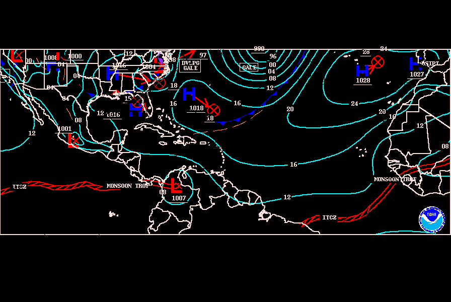
Just an observation I noticed that NHC has the surfacae low moving in a more WSW direction any comments.

Just an observation I noticed that NHC has the surfacae low moving in a more WSW direction any comments.
0 likes
Re: INVEST 91L : East of Lesser Antilles : Discussions & Images
cycloneye wrote:
The center is now exposed.
I don't believe that's the actual center. It's some sort of vortex spinning around the main center a little back SW. If you look at the surrounding buoys, you see the wind directions support the low further back SW. There MLC is also spinning back in around 49W
0 likes
Re:
Gustywind wrote:Atlantic Tropical Weather Discussion
--------------------------------------------------------------------------------
000
AXNT20 KNHC 061825
TWDAT
TROPICAL WEATHER DISCUSSION
NWS TPC/NATIONAL HURRICANE CENTER MIAMI FL
205 PM EDT SAT OCT 06 2007
TROPICAL WEATHER DISCUSSION FOR NORTH AMERICA...CENTRAL
AMERICA...THE GULF OF MEXICO...THE CARIBBEAN SEA...NORTHERN
SECTIONS OF SOUTH AMERICA...AND THE ATLANTIC OCEAN TO THE
AFRICAN COAST FROM THE EQUATOR TO 32N. THE FOLLOWING INFORMATION
IS BASED ON SATELLITE IMAGERY...METEOROLOGICAL ANALYSIS...
WEATHER OBSERVATIONS...AND RADAR.
BASED ON 1200 UTC SURFACE ANALYSIS AND SATELLITE IMAGERY
THROUGH 1715 UTC.
...TROPICAL WAVES...
TROPICAL WAVE IS IN THE CENTRAL ATLANTIC ALONG 50W S OF 20N
MOVING W 10 KT. A 1009 MB LOW IS ALONG THE WAVE AXIS NEAR
14.5N. THE INTERACTION BETWEEN THIS WAVE AND DIFFLUENCE ALOFT
TO THE E OF AN UPPER TROUGH HAS CAUSED CONVECTION TO FLARE UP
ALONG AND TO THE E OF THE WAVE/LOW FROM 10N-20N BETWEEN
46W-51W.
SLOW DEVELOPMENT IS POSSIBLE DURING THE NEXT 24 HOURS DESPITE UNFAVORABLE WLY UPPER LEVEL
WINDS.
I don't get the last line
 Why do they think development is possible despite hostile conditions?Is it suppose to be some kind of magical wave?
0 likes
- Matt-hurricanewatcher
- Category 5

- Posts: 11649
- Age: 38
- Joined: Fri Nov 26, 2004 11:09 pm
- Location: Portland,OR
- Contact:
Re: INVEST 91L : East of Lesser Antilles : Discussions & Images
This seems to be the second most organized system to 95L in the Atlatnic at the moment. But the convection is being pushed away from the LLC.
0 likes
-
curtadams
- S2K Supporter

- Posts: 1118
- Joined: Sun Aug 28, 2005 7:57 pm
- Location: Orange, California
- Contact:
Re: INVEST 91L : East of Lesser Antilles : Discussions & Images
I think the center has reformed. There's an extremely obvious, and very large, cyclonic rotation in the middle of the convection if you look on shortwave.
0 likes
- Gustywind
- Category 5

- Posts: 12334
- Joined: Mon Sep 03, 2007 7:29 am
- Location: Baie-Mahault, GUADELOUPE
000
ABNT20 KNHC 062108
TWOAT
TROPICAL WEATHER OUTLOOK
NWS TPC/NATIONAL HURRICANE CENTER MIAMI FL
530 PM EDT SAT OCT 6 2007
FOR THE NORTH ATLANTIC...CARIBBEAN SEA AND THE GULF OF MEXICO...
AN AREA OF LOW PRESSURE CENTERED ABOUT 600 MILES EAST OF THE LESSER
ANTILLES HAS BECOME LESS ORGANIZED THIS AFTERNOON. UPPER-LEVEL
WINDS ARE NOT FAVORABLE FOR
SIGNIFICANT DEVELOPMENT...AND THE
CHANCES FOR THIS SYSTEM TO BECOME A TROPICAL DEPRESSION ARE
DIMINISHING.
THIS LOW IS EXPECTED TO MOVE SLOWLY NORTHWESTWARD
DURING THE NEXT DAY OR SO.
0 likes
- cycloneye
- Admin

- Posts: 139122
- Age: 67
- Joined: Thu Oct 10, 2002 10:54 am
- Location: San Juan, Puerto Rico
Re: INVEST 91L : East of Lesser Antilles : Discussions & Images
06/2345 UTC 15.1N 52.2W T1.0/1.0 91L -- Atlantic Ocean
http://www.ssd.noaa.gov/PS/TROP/positions.html
http://www.ssd.noaa.gov/PS/TROP/positions.html
0 likes
Re: INVEST 91L : East of Lesser Antilles : Discussions & Images
This evening's QS pass shows no surface circulation:
http://manati.orbit.nesdis.noaa.gov/dat ... MBds26.png
http://manati.orbit.nesdis.noaa.gov/dat ... MBds26.png
0 likes
- cycloneye
- Admin

- Posts: 139122
- Age: 67
- Joined: Thu Oct 10, 2002 10:54 am
- Location: San Juan, Puerto Rico
Re: INVEST 91L : Models Thread
TROPICAL CYCLONE GUIDANCE MESSAGE
NWS TPC/NATIONAL HURRICANE CENTER MIAMI FL
0021 UTC SUN OCT 7 2007
DISCLAIMER...NUMERICAL MODELS ARE SUBJECT TO LARGE ERRORS.
PLEASE REFER TO NHC OFFICIAL FORECASTS FOR TROPICAL CYCLONE
AND SUBTROPICAL CYCLONE INFORMATION.
ATLANTIC OBJECTIVE AIDS FOR
DISTURBANCE INVEST (AL912007) 20071007 0000 UTC
...00 HRS... ...12 HRS... ...24 HRS. .. ...36 HRS...
071007 0000 071007 1200 071008 0000 071008 1200
LAT LON LAT LON LAT LON LAT LON
BAMS 15.1N 52.2W 16.0N 54.4W 16.9N 56.0W 17.7N 57.7W
BAMD 15.1N 52.2W 15.9N 53.2W 16.8N 54.3W 17.7N 55.2W
BAMM 15.1N 52.2W 15.9N 53.9W 16.7N 55.4W 17.4N 56.8W
LBAR 15.1N 52.2W 16.1N 53.3W 17.3N 54.3W 18.5N 54.9W
SHIP 25KTS 26KTS 27KTS 30KTS
DSHP 25KTS 26KTS 27KTS 30KTS
...48 HRS... ...72 HRS... ...96 HRS. .. ..120 HRS...
071009 0000 071010 0000 071011 0000 071012 0000
LAT LON LAT LON LAT LON LAT LON
BAMS 18.7N 58.9W 20.6N 60.6W 22.8N 61.7W 26.2N 61.1W
BAMD 18.7N 56.2W 20.8N 57.5W 23.8N 57.4W 25.2N 54.0W
BAMM 18.3N 58.2W 20.1N 60.5W 21.9N 62.5W 25.4N 63.1W
LBAR 20.1N 55.0W 24.0N 52.2W 28.6N 45.9W 31.1N 37.5W
SHIP 34KTS 46KTS 54KTS 56KTS
DSHP 34KTS 46KTS 54KTS 56KTS
...INITIAL CONDITIONS...
LATCUR = 15.1N LONCUR = 52.2W DIRCUR = 290DEG SPDCUR = 8KT
LATM12 = 14.4N LONM12 = 50.3W DIRM12 = 295DEG SPDM12 = 6KT
LATM24 = 13.9N LONM24 = 49.6W
WNDCUR = 25KT RMAXWD = 30NM WNDM12 = 25KT
CENPRS = 1008MB OUTPRS = 1012MB OUTRAD = 150NM SDEPTH = M
RD34NE = 0NM RD34SE = 0NM RD34SW = 0NM RD34NW = 0NM
0 likes
- HurricaneMaster_PR
- Category 2

- Posts: 795
- Joined: Tue Jul 22, 2003 6:23 pm
- Location: San Juan, Puerto Rico
Re: INVEST 91L : East of Lesser Antilles : Discussions & Images
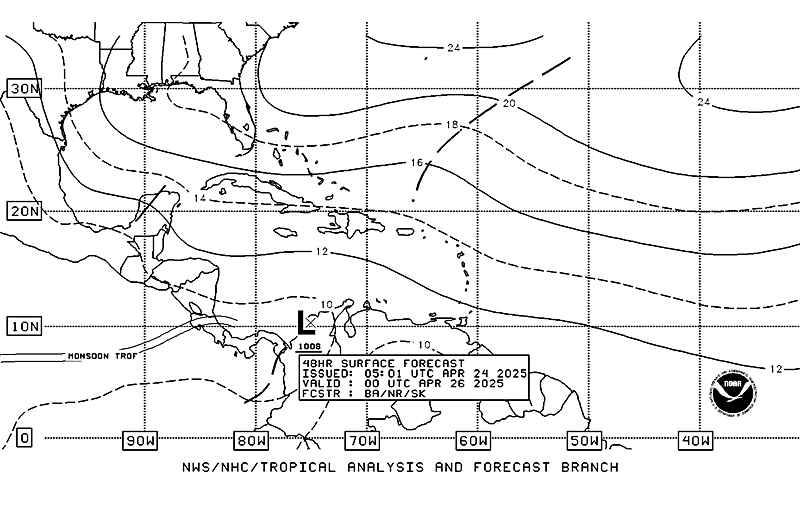
TAFB forecast tonight a Possible Tropical Cyclone approaching the Caribbean within the next 48 hours.

0 likes
- Gustywind
- Category 5

- Posts: 12334
- Joined: Mon Sep 03, 2007 7:29 am
- Location: Baie-Mahault, GUADELOUPE
Re: INVEST 91L : East of Lesser Antilles : Discussions & Images
HurricaneMaster_PR wrote:TAFB forecast tonight a Possible Tropical Cyclone approaching the Caribbean within the next 48 hours.
Interresting...approaching East Carib...and very close to Guadeloupe
To sump up, in my humble opinion all that story is not very clear....NHC speaking about a system expected to move NW and this thing is indicated to be in the east south east of Guadeloupe on this map... in the next 48 h, did i miss something?!

0 likes
- cycloneye
- Admin

- Posts: 139122
- Age: 67
- Joined: Thu Oct 10, 2002 10:54 am
- Location: San Juan, Puerto Rico
Re: INVEST 91L : East of Lesser Antilles : Discussions & Images
10:30 PM TWO
AN AREA OF LOW PRESSURE CENTERED ABOUT 550 MILES EAST OF THE LESSER
ANTILLES HAS CHANGED LITTLE THIS EVENING. UPPER-LEVEL WINDS ARE NOT
FAVORABLE FOR SIGNIFICANT DEVELOPMENT AND THIS LOW IS EXPECTED TO
MOVE SLOWLY NORTHWESTWARD DURING THE NEXT DAY OR SO.
AN AREA OF LOW PRESSURE CENTERED ABOUT 550 MILES EAST OF THE LESSER
ANTILLES HAS CHANGED LITTLE THIS EVENING. UPPER-LEVEL WINDS ARE NOT
FAVORABLE FOR SIGNIFICANT DEVELOPMENT AND THIS LOW IS EXPECTED TO
MOVE SLOWLY NORTHWESTWARD DURING THE NEXT DAY OR SO.
0 likes
Who is online
Users browsing this forum: No registered users and 70 guests


