ATL GUSTAV: Tropical Depression - Discussion
Moderator: S2k Moderators
-
SouthFloridawx

- S2K Supporter

- Posts: 8346
- Age: 47
- Joined: Tue Jul 26, 2005 1:16 am
- Location: Sarasota, FL
- Contact:

Re: ATL: Invest 94L in Eastern Caribbean Sea=TCFA Issued
94 does look impressive. Oh boy. The models are very interesting.
http://www.wunderground.com/tropical/tr ... model.html
http://www.wunderground.com/tropical/tr ... model.html
0 likes
-
GeneratorPower

- S2K Supporter
- Posts: 1648
- Age: 46
- Joined: Sun Dec 18, 2005 11:48 pm
- Location: Huntsville, AL
Re: ATL: Invest 94L in Eastern Caribbean Sea=TCFA Issued
what is the mechanism that is supposed to cause a weakness near 75 w
http://www.ssd.noaa.gov/goes/east/nwatl/loop-wv.html
seems the ULL is moving slowly Ne, so i wouldn't think this would be the source, though i dunno
anyone have insights
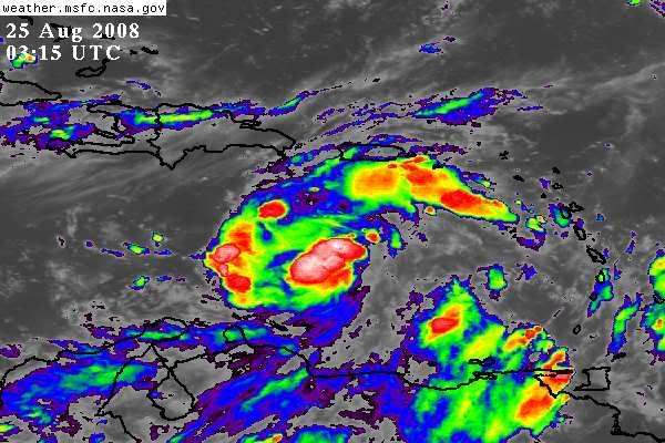
also thru 315 utc still looking nice and black on the IR
http://www.ssd.noaa.gov/goes/east/nwatl/loop-wv.html
seems the ULL is moving slowly Ne, so i wouldn't think this would be the source, though i dunno
anyone have insights
also thru 315 utc still looking nice and black on the IR
0 likes
-
SouthFLTropics

- Category 5

- Posts: 4258
- Age: 50
- Joined: Thu Aug 14, 2003 8:04 am
- Location: Port St. Lucie, Florida
Re: ATL: Invest 94L in Eastern Caribbean Sea=TCFA Issued
twister wrote:94 does look impressive. Oh boy. The models are very interesting.
http://www.wunderground.com/tropical/tr ... model.html
Interesting or confusing...I don't know which to call it...
SFT
0 likes


-
cycloneye

- Admin

- Posts: 149310
- Age: 69
- Joined: Thu Oct 10, 2002 10:54 am
- Location: San Juan, Puerto Rico
Re: ATL: Invest 94L in Eastern Caribbean Sea=TCFA Issued
Here is the text of the TCFA:
WTNT01 KNGU 250001
SUBJ/TROPICAL CYCLONE FORMATION ALERT 250000Z AUG 08//
1. FORMATION OF A SIGNIFICANT TROPICAL CYCLONE IS POSSIBLE WITHIN
100 NM EITHER SIDE OF A LINE FROM 12.9N 66.5W TO 15.5N 72.4W
WITHIN THE NEXT 24 HOURS. AVAILABLE DATA DOES NOT JUSTIFY
ISSUANCE OF NUMBERED TROPICAL CYCLONE WARNINGS AT THIS TIME.
WINDS IN THE AREA ARE ESTIMATED TO BE 20 TO 25 KNOTS. METSAT
IMAGERY AT 250000Z INDICATES THAT A CIRCULATION CENTER IS LOCATED
NEAR 13.5N 67.7W. THE SYSTEM IS MOVING WEST-NORTHWESTWARD AT 10
TO 15 KNOTS.
2. REMARKS: A BROAD AREA OF LOW PRESSURE IS BEGINNING TO
DEVELOP ALONG AN EASTERLY WAVE IN THE EASTERN CARIBBEAN
SEA, ROUGHLY 300NM TO THE SOUTH-SOUTHEAST OF PUERTO RICO, MOVING
TO THE WEST-NORTHWEST. ESTIMATED CENTRAL PRESSURE IS 1008MB WITH
SURFACE WINDS OF 20 TO 25 KNOTS ALONG THE NORTHERN PERIPHERY
OF THE SYSTEM. AREAS OF CONVECTION ARE GRADUALLY BECOMING BETTER
ORGANIZED AND ROTATION IS EVIDENT IN VISIBLE SATELLITE IMAGERY.
LOW VERTICAL WIND SHEAR CONDITIONS AND WARM SEA SURFACE TEMPERATURES
(82F) EXIST DOWNSTREAM INTO THE CENTRAL CARIBBEAN SEA ENHANCING
THE POSSIBILITY FOR TROPICAL CYCLONE DEVELOPMENT.
3. THIS ALERT WILL BE REISSUED, UPGRADED TO WARNING OR CANCELLED
BY 260000Z.//
0 likes
-
southmdwatcher
- Tropical Low

- Posts: 25
- Joined: Thu Aug 14, 2008 5:35 am
Re: ATL: Invest 94L in Eastern Caribbean Sea=TCFA Issued
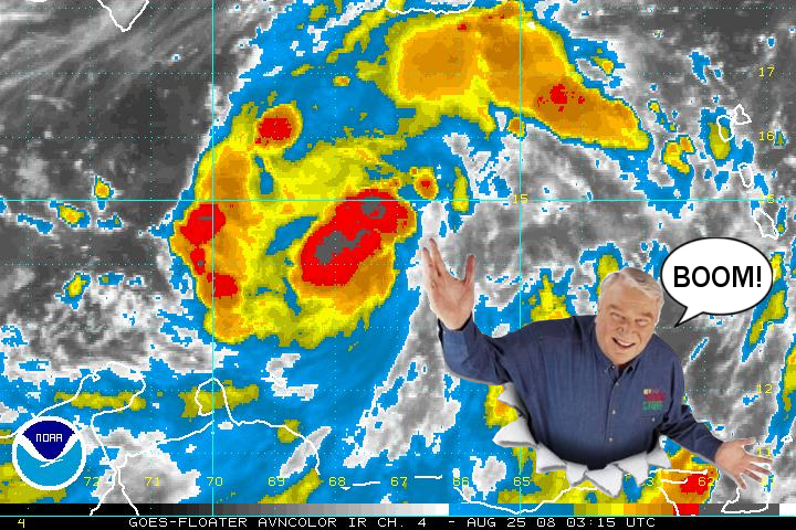
It really does not look like 94I is going to be a slow developer, ala Dolly and Fay. Ole Gustav looks like its going to be a charging bear through the Carribean. The convection and structure are improving with each satellite frame.
0 likes
-
SouthFLTropics
- Category 5
- Posts: 4258
- Age: 50
- Joined: Thu Aug 14, 2003 8:04 am
- Location: Port St. Lucie, Florida
Re:
CajunMama wrote:I'm having a fay thread deja vu!
No joke Cajun...It looks like we are getting ready to do this all over again!!!
SFT
0 likes
-
vbhoutex

- Storm2k Executive
- Posts: 29146
- Age: 74
- Joined: Wed Oct 09, 2002 11:31 pm
- Location: Cypress, TX
- Contact:
Re: ATL: Invest 94L in Eastern Caribbean Sea=TCFA Issued
I have to admit I haven't been following 94L too closely, but based on what I see tonight posted here(especially Aric's post above, if there is an LLCC forming it is on the far south end of all of the convection(basically based on the quickscat). I actually think there is still an axis as opposed to any LLCC(maybe a try at an elongated LLCC situated SW-NE). Persistance of the heavy convection could turn this into a different story quickly though, if my thoughts are correct.
0 likes
-
Aric Dunn
- Category 5
- Posts: 21238
- Age: 43
- Joined: Sun Sep 19, 2004 9:58 pm
- Location: Ready for the Chase.
- Contact:
radar.. showing very clear circulation.
http://www.weather.an/product_images/hi ... color.html
http://www.weather.an/product_images/hi ... color.html
0 likes

Re: ATL: Invest 94L in Eastern Caribbean Sea=TCFA Issued
Going to take a little while, but it looks like all systems go.
0 likes

-
SouthFLTropics
- Category 5
- Posts: 4258
- Age: 50
- Joined: Thu Aug 14, 2003 8:04 am
- Location: Port St. Lucie, Florida
Re:
RL3AO wrote:
I see that ACE Hardware is getting in on the Hurricane supply boom...LOL

SFT
0 likes
-
Sean in New Orleans

- Category 5
- Posts: 1794
- Joined: Thu Aug 28, 2003 7:26 pm
- Location: New Orleans, LA 30.0N 90.0W
- Contact:
Let me make it VERY clear: I am watching this one and I am concerned. For starters, think about the time of the year it is---we are basically getting towards the most active time and we are approaching a time when powerful systems can form very quickly. This could easily turn into something very significant and with its location, we could certainly see a landfalling system on the United States. Stay tuned--I am.
0 likes
-
AtlanticWind
- S2K Supporter
- Posts: 1898
- Age: 67
- Joined: Sun Aug 08, 2004 9:57 pm
- Location: Plantation,Fla
Re:
Aric Dunn wrote:radar.. showing very clear circulation.
http://www.weather.an/product_images/hi ... color.html
Good Find , and looks like just about where you estimate the center from the IR
0 likes
-
meteorologyman
- Category 2

- Posts: 541
- Joined: Wed Mar 15, 2006 6:48 pm
- Location: Florida, Kissimmee/St.CLoud
Re: ATL: Invest 94L in Eastern Caribbean Sea=TCFA Issued
ACE the helpful place
Well certainly can't wait for the sun to shine to see satellite imagery.
prepare for the worst, hope for the best as this thing becomes better organized.
Well certainly can't wait for the sun to shine to see satellite imagery.
prepare for the worst, hope for the best as this thing becomes better organized.
0 likes
Who is online
Users browsing this forum: No registered users and 14 guests