

southmdwatcher wrote:Looks like very deep convection is erupting in the area around the center(south and east side)
[img][/img]http://www.meteo.psu.edu/~gadomski/SATRAPID/anim16ir.html
Seems to be getting a bit bigger again too.
Moderator: S2k Moderators
southmdwatcher wrote:Looks like very deep convection is erupting in the area around the center(south and east side)
[img][/img]http://www.meteo.psu.edu/~gadomski/SATRAPID/anim16ir.html


WxGuy1 wrote:Derek Ortt wrote:I have seen dry air mentioned on this forum a lot lately... and despite explaining what is needd for dry air to cause weakening, we still see the same wrong info posted time and again
without shear, dry air cannot penetrate the core
Derek,
Certainly you looked at visible satellite imagery quite a few times on Wednesday. It was very apparent that dry air was being entrained into Ike from the west. The IR didn't show it well because there was some thin cirrus overhead, but it was quite evident on visible satellite imagery. You've mentioned this enough times that I'm going to see if I can find a good vis sat image from yesterday to show as evidence.
Of course, you're only saying that dry air means nothing w/o shear, and you're not necessarily saying that shear was not present yesterday. However, you seem to be implying that dry air has had NO effect on Ike, an implication with which I disagree.
Derek Ortt wrote:I have seen dry air mentioned on this forum a lot lately... and despite explaining what is needd for dry air to cause weakening, we still see the same wrong info posted time and again
without shear, dry air cannot penetrate the core

cycloneye wrote:Ike will be one that the mets here and in the NHC will make plenty of studies about its unique track and about its eternal struggle to organize one inner core.
Steve wrote:>>It would be pretty crazy for two storms to spend over 36 hours each in the GOM in Late August/Early September and not get stronger and maybe actually weaken.
Dynomat?
------------------------
We're seeing some near TS conditions this evening down my way after some tidal flooding throughout NWFL, AL, MS and SELA this evening. Not bad for a storm as far away as Ike currently is from me.
Steve

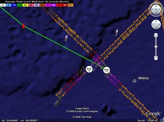
cycloneye wrote:Almost due west in the last two fixes.The gree line is the 10 PM Advisory track.
Users browsing this forum: No registered users and 42 guests


