http://www.wunderground.com/blog/JeffMa ... amp=200808Where will Fay go next?
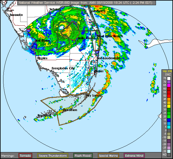
The computer models continue to disagree on the long-term path of Fay. Most of the models now agree that the trough of low pressure pulling the storm to the north will not be strong enough to finish the job. Fay will probably be left behind by the trough, and forced westward by a ridge of high pressure expected to build in. The official NHC forecast keeps Fay over Florida and turns the storm to the west over southern Georgia. However, most of the models expect this turn to occur further south, and have been trending further south in recent runs. I give Fay a 60% chance surviving its traverse over Florida, then turning back to the west over the northern Gulf of Mexico by Saturday. This would allow the storm to regenerate, before potentially making landfall again along the northern Gulf Coast between New Orleans and the Florida Panhandle early next week. The GFDL has the rather unnerving solution of pushing Fay out into the Atlantic Wednesday, intensifying it to a strong Category 2 hurricane that then hits the Georgia/Florida border region Friday night. The HWRF is similar, but foresees that Fay will only be a 50-55 mph tropical storm when it hits Georgia. Given the rather high levels of wind shear (15-20 knots) predicted to be over Fay late this week, plus Fay's recent inability to build an eyewall in the 24 hours it had over the Florida Straits, I am discounting the GFDL model's solution of a hurricane hitting Georgia. However, Fay may push out to into the Atlantic far enough to regenerate some on Thursday or Friday, before it is forced back west again over northern Florida or southern Georgi
I think this is going to be a long week/weekend for anyone who lives near the GOM and/or Atlantic Ocean. At least I am off this weekend but I bet if we go under any type of watch/warning I will be at Target.