ATL: IKE Discussion
Moderator: S2k Moderators
Re: ATL IKE: Category 2 - Discussion
MSNBC met reiterated....15-20 foot surge from where eye makes landfall to TX/LA border.
0 likes
-
PTrackerLA

- Category 5

- Posts: 5281
- Age: 42
- Joined: Thu Oct 10, 2002 8:40 pm
- Location: Lafayette, LA
Re: ATL IKE: Category 2 - Discussion
Just a side note, I think many of the "tropical storm force winds" radius maps are bogus. According to almost every image I've seen, we should be well within sustain TS winds in Lafayette. There hasn't been a gust over 30 all day.
0 likes

Re: ATL IKE: Category 2 - Discussion
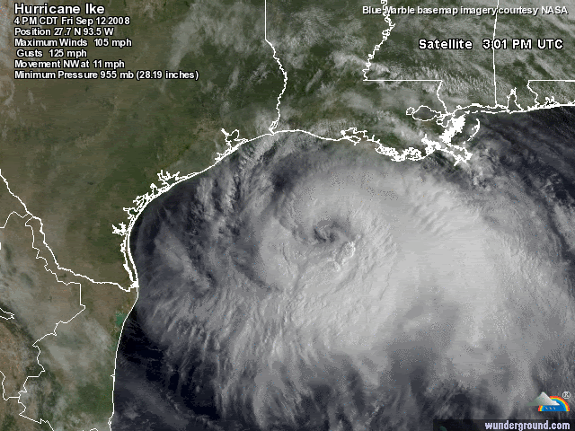
URNT12 KNHC 122102
VORTEX DATA MESSAGE AL092008
A. 12/20:38:30Z
B. 27 deg 54 min N
093 deg 21 min W
C. 700 mb 2715 m
D. 89 kt
E. 033 deg 48 nm
F. 128 deg 105 kt
G. 038 deg 071 nm
H. 955 mb
I. 11 C/ 3049 m
J. 19 C/ 3051 m
K. 11 C/ NA
L. OPEN WEST
M. C60
N. 12345/7
O. 0.02 / 1 nm
P. AF304 3309A IKE OB 04
MAX FL WIND 105 KT NE QUAD 20:17:20 Z
0 likes
Re: ATL IKE: Category 2 - Discussion
I have been reading a lot of this thread and about this seawall... It's what, 18 feet high? But then I see the ABC13 live feed from here time and time again showing the water thrashing that wall... and it looks like less than 10 feet of the wall is still remaining, I'd go as low as probably 5 feet
and the surge of upto 20 feet is still going to come on top of what we're seeing already?
I think this surge is being underestimated...
Also, Ike's finally clearing out his eye from the IR images it seems
and the surge of upto 20 feet is still going to come on top of what we're seeing already?
I think this surge is being underestimated...
Also, Ike's finally clearing out his eye from the IR images it seems
0 likes


-
Txdivermom
- Tropical Low

- Posts: 47
- Joined: Sun Aug 31, 2008 11:49 am
Re: ATL IKE: Category 2 - Discussion
Time Traveller wrote:Interesting. The local news reported that a lot of the people that are being rescued by helicopter said they thought they had more time. The waters rose much quicker than they had anticipated. Not good. And Ike is still 12 hours out.
I don't get "thought they had more time". They were told to leave at 12 noon yesterday. And the 16 kids guy....sorry buddy...no excuses. There were buses leaving Galveston yesterday all day long. FREE buses. All you had to do was call if you couldn't get there. I saw plenty of people with kids on tv getting on those buses. He made a bad decision for his family and it didn't have anything to do with his resources.
0 likes
Re: ATL IKE: Category 2 - Discussion
Tightening eye with improved convection in NW eyewall. Open slot to NE in eyewall:
http://radar.weather.gov/ridge/radar.php?rid=HGX&product=N0Z&overlay=11101111&loop=yes
http://radar.weather.gov/ridge/radar.php?rid=HGX&product=N0Z&overlay=11101111&loop=yes
0 likes

Re: ATL IKE: Category 2 - Discussion
PTrackerLA wrote:Just a side note, I think many of the "tropical storm force winds" radius maps are bogus. According to almost every image I've seen, we should be well within sustain TS winds in Lafayette. There hasn't been a gust over 30 all day.
The NHC's wind radii are given for the maximum extent of gale, storm, and hurricane force winds. Being within the tropical storm radii does not necessarily mean a location will 100% receive tropical storm force winds. Instead, it means that tropical storm force winds are possible.
- Jay
0 likes


Re: ATL IKE: Category 2 - Discussion
When they say 'up to 275 miles'....and it is a bit misleading...that is not the same as drawing a 275-mile wide circle around eye. The different storm quadrants have different radius of winds. Factor in some reduction over land too. Things have yet to really get going away from coast and it will get much worse...but we are clearly talking 2 storms...a surge Cat 4 and wind Cat 2 (most will see sustained cat 1) As of 4pm CDT:
ESTIMATED MINIMUM CENTRAL PRESSURE 955 MB
MAX SUSTAINED WINDS 90 KT WITH GUSTS TO 110 KT.
64 KT.......105NE 90SE 50SW 60NW.
50 KT.......150NE 150SE 75SW 90NW.
34 KT.......240NE 200SE 150SW 170NW.
12 FT SEAS..390NE 360SE 270SW 240NW.
Compared to 10am CDT....
ESTIMATED MINIMUM CENTRAL PRESSURE 954 MB
MAX SUSTAINED WINDS 90 KT WITH GUSTS TO 110 KT.
64 KT.......105NE 75SE 60SW 60NW.
50 KT.......150NE 150SE 100SW 140NW.
34 KT.......240NE 200SE 150SW 180NW.
12 FT SEAS..390NE 360SE 270SW 240NW.
PTrackerLA wrote:Just a side note, I think many of the "tropical storm force winds" radius maps are bogus. According to almost every image I've seen, we should be well within sustain TS winds in Lafayette. There hasn't been a gust over 30 all day.
0 likes

Re: ATL IKE: Category 2 - Discussion
Jijenji wrote:Agua wrote:
holy cow. Maybe it was chosen because it was the only thing capable of holding a large # of people.
Got a feeling there are going to be a lot of individual, spontaneous, "shelters of last resort" for Galvestonians.
I can't stress enough that other things besides humans will be seeking out those shelters of last resort too.
Yep..... snakes, ants, and kinds of unfriendly critters.
0 likes
-
MiamiensisWx
Re: ATL IKE: Category 2 - Discussion
There is a slight NW wobble on the latest GOES visible satellite frame. In addition, forward movement appears to be decreasing slightly.
http://www.ssd.noaa.gov/goes/east/tatl/loop-vis.html
If this trend continues, it would imply a landfall over the city of Galveston or slightly closer than previous estimates; in other words, it may be closer to the current center of the NHC's cone.
The wind radii also appears to be decreasing slightly... however, as the eye contracts, the RMW will decrease and would still support the highest surge values over Galveston, Galveston Bay, and points farther east.
On another note, I want to apologize for my "Darwin" comment... it was merely upsetting that so many residents are still on the island of Galveston. I'm quite concerned for them and others.
Last edited by MiamiensisWx on Fri Sep 12, 2008 4:13 pm, edited 2 times in total.
0 likes
-
MaryEllen71
- Tropical Low
- Posts: 21
- Joined: Wed Sep 10, 2008 11:29 pm
Re: ATL IKE: Category 2 - Discussion
IS anyone watching the weather channel right now? Jim Cantore looks very concerned and Mike Seidell who is at Surfside just called a family who were in their house riding it out "stupid"
0 likes
-
gtalum

- S2K Supporter

- Posts: 4749
- Age: 50
- Joined: Tue Sep 07, 2004 3:48 pm
- Location: Bradenton, FL
- Contact:
Re: ATL IKE: Category 2 - Discussion
LAwxrgal wrote:I fear a Katrina NO Superdome and Convention Center situation repeating itself, of course, I hope not.
If the high school is low-lying, it would be worse. At least everyone survived at the Superdome.
0 likes
Re: ATL IKE: Category 2 - Discussion
4pm CDT conditions....please keep in mind that houston is in weaker nw quadrant now....it will get much worse
HOUSTON BUSH N17
HOUSTON HOBBY N25G32
PEARLAND NE21G32
HOUSTON HOOKS NE14G2
PORT ARTHUR NE28G37
GALVESTON NOT AVBL
N.O. INTL ARPT SE25G41
N.O. LAKEFRONT SE35G43
HOUMA E35G46
HOUSTON BUSH N17
HOUSTON HOBBY N25G32
PEARLAND NE21G32
HOUSTON HOOKS NE14G2
PORT ARTHUR NE28G37
GALVESTON NOT AVBL
N.O. INTL ARPT SE25G41
N.O. LAKEFRONT SE35G43
HOUMA E35G46
0 likes
Who is online
Users browsing this forum: No registered users and 202 guests