ATL HANNA: Extratropical - Discussion

Moderator: S2k Moderators

Message
Author
User avatar
Blown Away
S2K Supporter
S2K Supporter
Posts: 10152
Joined: Wed May 26, 2004 6:17 am

Re: ATL: Tropical Storm Hanna in Western Atlantic

#1541 Postby Blown Away » Sun Aug 31, 2008 12:38 pm

Image

Boy does that look like an eye forming? I don't think it is but it looks like it.
0 likes   

User avatar
vacanechaser
Category 5
Category 5
Posts: 1461
Joined: Wed Dec 03, 2003 9:34 pm
Location: Portsmouth, Va
Contact:

Re: ATL: Tropical Storm Hanna in Western Atlantic

#1542 Postby vacanechaser » Sun Aug 31, 2008 12:41 pm

Blown_away wrote:Image

Boy does that look like an eye forming? I don't think it is but it looks like it.


wow.. have not looked at a sat image in awhile... does look interesting thats for sure...

i agree, it is not one, but certainly looking like it is trying to wrap in


Jesse V. Bass III
http://www.vastormphoto.com
Hurricane Intercept Research Team
0 likes   

User avatar
Blown Away
S2K Supporter
S2K Supporter
Posts: 10152
Joined: Wed May 26, 2004 6:17 am

Re: ATL: Tropical Storm Hanna in Western Atlantic

#1543 Postby Blown Away » Sun Aug 31, 2008 12:45 pm

Hanna still moving a pretty good clip in order to stay on track she will have to slam on the brakes very soon.
http://www.ssd.noaa.gov/goes/flt/t2/loop-avn.html
0 likes   

User avatar
DESTRUCTION5
Category 5
Category 5
Posts: 4423
Age: 43
Joined: Wed Sep 03, 2003 11:25 am
Location: Stuart, FL

Re: ATL: Tropical Storm Hanna in Western Atlantic

#1544 Postby DESTRUCTION5 » Sun Aug 31, 2008 12:48 pm

Blown_away wrote:Hanna still moving a pretty good clip in order to stay on track she will have to slam on the brakes very soon.
http://www.ssd.noaa.gov/goes/flt/t2/loop-avn.html

LOL her and that ULL are still raging war on each other...Amazing how resiliant she is...
0 likes   

User avatar
sunnyday
Category 5
Category 5
Posts: 1590
Joined: Thu Sep 04, 2003 8:16 pm

Re: ATL: Tropical Storm Hanna in Western Atlantic

#1545 Postby sunnyday » Sun Aug 31, 2008 12:52 pm

This storm's path has been all over the place. It has been sw, w, and now heading n or nw. Such a variation is frightening. Now that it is supposed to miss S. Fl, is there a likelihood that I will see S Fl as the destination tomorrow? 8-)
0 likes   

User avatar
Vortex
S2K Supporter
S2K Supporter
Posts: 4644
Age: 53
Joined: Fri Aug 01, 2003 9:34 pm
Location: Hilton Head, SC

#1546 Postby Vortex » Sun Aug 31, 2008 12:52 pm

12Z ukmet heads sw to the north coast of cuba then west along the north cuban coast then nw/nnw towards and over SFL. NHC noted the Ukmet in their discussion and ukmet has been very consistent with this scenario.


http://moe.met.fsu.edu/cgi-bin/ukmtc2.c ... =Animation
0 likes   

User avatar
HURAKAN
Professional-Met
Professional-Met
Posts: 46086
Age: 38
Joined: Thu May 20, 2004 4:34 pm
Location: Key West, FL
Contact:

#1547 Postby HURAKAN » Sun Aug 31, 2008 12:53 pm

518
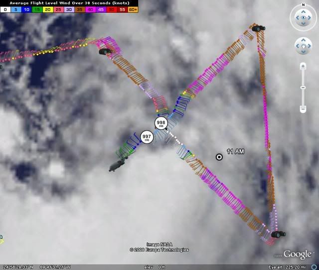
URNT12 KNHC 311751
VORTEX DATA MESSAGE
A. 31/17:36:20Z
B. 23 deg 32 min N
070 deg 56 min W
C. 850 mb 1412 m
D. 44 kt
E. 046 deg 105 nm
F. 122 deg 045 kt
G. 043 deg 049 nm
H. 997 mb
I. 19 C/ 1520 m
J. 19 C/ 1520 m
K. 17 C/ NA
L. NA
M. NA
N. 12345/8
O. 0.02 / 4 nm
P. AF302 0108A HANNA OB 10
MAX FL WIND 48 KT SE QUAD 15:59:10 Z
MAX FL TEMP 20 C, 43 / 49NM

Image
0 likes   

User avatar
Evil Jeremy
S2K Supporter
S2K Supporter
Posts: 5463
Age: 32
Joined: Mon Apr 10, 2006 2:10 pm
Location: Los Angeles, CA

#1548 Postby Evil Jeremy » Sun Aug 31, 2008 12:56 pm

I think that the models will continue to move westward as the storm continues to move at 10+ MPH. The new GFDL has also shifted westward, showing landfall on the South/North Carolina border.
0 likes   

User avatar
KWT
Category 5
Category 5
Posts: 31415
Joined: Tue Aug 17, 2004 11:02 am
Location: UK!!!

#1549 Postby KWT » Sun Aug 31, 2008 12:56 pm

It looks very messy right now, theres no real organisation of the convective coverage its just constantly blowing up convection which may be keeping the LLC from really wekaneing too much.

Good job the shear is real intense because look at the way its constantly bursting.
0 likes   

User avatar
artist
Category 5
Category 5
Posts: 9792
Joined: Mon Jun 06, 2005 3:26 pm
Location: West Palm

#1550 Postby artist » Sun Aug 31, 2008 12:57 pm

I will be so glad when we are finally within the 3 day cone or less. Then we should have a much better idea as to where she will land.
0 likes   

cpdaman
Category 5
Category 5
Posts: 3131
Joined: Sat Jun 10, 2006 11:44 am
Location: SPB county (gulf stream)

Re: ATL: Tropical Storm Hanna in Western Atlantic

#1551 Postby cpdaman » Sun Aug 31, 2008 12:59 pm

vacanechaser wrote:
Blown_away wrote:Image

Boy does that look like an eye forming? I don't think it is but it looks like it.


wow.. have not looked at a sat image in awhile... does look interesting thats for sure...

i agree, it is not one, but certainly looking like it is trying to wrap in


Jesse V. Bass III
http://www.vastormphoto.com
Hurricane Intercept Research Team


no i don't think that's possible

that feature is at 72.5 or 73 (now) W, while the recon fix is much further ENE at 71 W

surely no eye , not even a LLC, i was wondering if that could be a MLC, since i usually don't see brite red surroundig a ULL.
Last edited by cpdaman on Sun Aug 31, 2008 1:02 pm, edited 2 times in total.
0 likes   

User avatar
captain east
Tropical Storm
Tropical Storm
Posts: 213
Joined: Thu Aug 28, 2008 2:53 pm
Location: South East Florida

Re: ATL: Tropical Storm Hanna in Western Atlantic

#1552 Postby captain east » Sun Aug 31, 2008 1:00 pm

Winds down to 45 mph, but it went down to 997 mb and is currently moving west pretty fast at 12 mph..
0 likes   

User avatar
Evil Jeremy
S2K Supporter
S2K Supporter
Posts: 5463
Age: 32
Joined: Mon Apr 10, 2006 2:10 pm
Location: Los Angeles, CA

#1553 Postby Evil Jeremy » Sun Aug 31, 2008 1:04 pm

New UKMET is in. SFL landfall from the east, without making landfall in Cuba.
0 likes   

cpdaman
Category 5
Category 5
Posts: 3131
Joined: Sat Jun 10, 2006 11:44 am
Location: SPB county (gulf stream)

Re: ATL: Tropical Storm Hanna in Western Atlantic

#1554 Postby cpdaman » Sun Aug 31, 2008 1:05 pm

vane chaser do you think that feature could be the MLC while the LLC is futher NE by the recon fix, also seems like LLC want's to follow that feature pretty closely.

we need to watch any storm in this position very very closely , especially one that can sneak up on us (moving 12mph) while everyone else watches gustav
0 likes   

User avatar
captain east
Tropical Storm
Tropical Storm
Posts: 213
Joined: Thu Aug 28, 2008 2:53 pm
Location: South East Florida

Re:

#1555 Postby captain east » Sun Aug 31, 2008 1:05 pm

Evil Jeremy wrote:New UKMET is in. SFL landfall from the east, without making landfall in Cuba.

Can you post the model please, I'd like to see it.
0 likes   

User avatar
Evil Jeremy
S2K Supporter
S2K Supporter
Posts: 5463
Age: 32
Joined: Mon Apr 10, 2006 2:10 pm
Location: Los Angeles, CA

Re: Re:

#1556 Postby Evil Jeremy » Sun Aug 31, 2008 1:07 pm

captain east wrote:
Evil Jeremy wrote:New UKMET is in. SFL landfall from the east, without making landfall in Cuba.

Can you post the model please, I'd like to see it.


It is the blue line with the squares. Even though it is the outlier, it is still a reliable model:

http://my.sfwmd.gov/sfwmd/common/images ... orm_08.gif
0 likes   

User avatar
storms in NC
S2K Supporter
S2K Supporter
Posts: 2338
Joined: Thu Jul 28, 2005 2:58 pm
Location: Wallace,NC 40 miles NE of Wilm
Contact:

#1557 Postby storms in NC » Sun Aug 31, 2008 1:10 pm

I think that is the ULL. But cause recon has it at . 23 deg 32 min N
070 deg 56 min W
0 likes   

User avatar
captain east
Tropical Storm
Tropical Storm
Posts: 213
Joined: Thu Aug 28, 2008 2:53 pm
Location: South East Florida

Re: Re:

#1558 Postby captain east » Sun Aug 31, 2008 1:11 pm

Evil Jeremy wrote:
captain east wrote:
Evil Jeremy wrote:New UKMET is in. SFL landfall from the east, without making landfall in Cuba.

Can you post the model please, I'd like to see it.


It is the blue line with the squares. Even though it is the outlier, it is still a reliable model:

http://my.sfwmd.gov/sfwmd/common/images ... orm_08.gif

Thanks. Anyways I think the models will start gradually drifting or drastically more to the west if it keeps moving this fast to the west.
Last edited by captain east on Sun Aug 31, 2008 1:13 pm, edited 1 time in total.
0 likes   

jinftl
Category 5
Category 5
Posts: 4312
Joined: Tue Aug 31, 2004 4:47 pm
Location: fort lauderdale, fl

Re: ATL: Tropical Storm Hanna in Western Atlantic

#1559 Postby jinftl » Sun Aug 31, 2008 1:12 pm

OK, Hanna is at the 12-hour forecast position that was set at 11am....so in 3 hours she got to where she was forecast to be at 11pm tonight. What's up?

FORECAST POSITIONS AND MAX WINDS

INITIAL 31/1500Z 23.3N 70.0W 45 KT
12HR VT 01/0000Z 23.4N 71.1W 45 KT


2pm position: 23.5N 71.1W
0 likes   

User avatar
Weatherboy1
Category 5
Category 5
Posts: 1189
Age: 49
Joined: Mon Jul 05, 2004 1:50 pm
Location: Jupiter/Sarasota, FL

#1560 Postby Weatherboy1 » Sun Aug 31, 2008 1:14 pm

appears that some of the easternmost models have shifted back somewhat to the west as of the midday runs, while the westernmost (UKMET) has shifted somewhat to the east. It also appears to me that Hanna may be moving more quickly to the W or slightly N of W. The net result could be a bit of a western shift of the NHC path forecast at 5 p.m., in my opinion. Anybody from the southern tip of FL up through the Outer Banks should keep a close eye on Hanna, as far as I'm concerned.
0 likes   


Return to “2008”

Who is online

Users browsing this forum: No registered users and 18 guests