ATL HANNA: Extratropical - Discussion

Moderator: S2k Moderators

Message
Author
User avatar
HURAKAN
Professional-Met
Professional-Met
Posts: 46086
Age: 38
Joined: Thu May 20, 2004 4:34 pm
Location: Key West, FL
Contact:

#1821 Postby HURAKAN » Mon Sep 01, 2008 6:37 am

Image

Oh, Hanna. What are you doing!!!!
0 likes   

User avatar
storms in NC
S2K Supporter
S2K Supporter
Posts: 2338
Joined: Thu Jul 28, 2005 2:58 pm
Location: Wallace,NC 40 miles NE of Wilm
Contact:

#1822 Postby storms in NC » Mon Sep 01, 2008 6:38 am

Hanna is looking better this morning. I still think she will be a large storm in size. last night on the news they said she would only be a TS at land fall. They might be right but given her size I don't think so. Today you will see her grow even more. I hav't looked to how thinks look as to where I think she will go. willl let you all know when I get some caffeen in me. :wink:
0 likes   

User avatar
KWT
Category 5
Category 5
Posts: 31415
Joined: Tue Aug 17, 2004 11:02 am
Location: UK!!!

#1823 Postby KWT » Mon Sep 01, 2008 6:40 am

Wow Hurakan its pulling a bit of a surprise now, the convection is looking really aamzing, even if the LLC is still somewhat on the NW side. Recon is going to be so very interesting to observe IF it can hold this look for another 4-6hrs or so
0 likes   

User avatar
Lowpressure
S2K Supporter
S2K Supporter
Posts: 2032
Age: 58
Joined: Sun Sep 14, 2003 9:17 am
Location: Charlotte, North Carolina

Re:

#1824 Postby Lowpressure » Mon Sep 01, 2008 6:45 am

KWT wrote:Wow Hurakan its pulling a bit of a surprise now, the convection is looking really aamzing, even if the LLC is still somewhat on the NW side. Recon is going to be so very interesting to observe IF it can hold this look for another 4-6hrs or so

I agree totally. Recon will be very interesting and perhaps surprised.
0 likes   

Sanibel
Category 5
Category 5
Posts: 10375
Joined: Mon Aug 30, 2004 11:06 pm
Location: Offshore SW Florida

Re: ATL: Tropical Storm Hanna in Western Atlantic

#1825 Postby Sanibel » Mon Sep 01, 2008 6:46 am

Right on cue when Gus gets weaker Hanna gets stronger.

Geesh! Look at that burst!
0 likes   

User avatar
Emmett_Brown
Category 5
Category 5
Posts: 1432
Joined: Wed Aug 24, 2005 9:10 pm
Location: Sarasota FL

Re: ATL: Tropical Storm Hanna in Western Atlantic

#1826 Postby Emmett_Brown » Mon Sep 01, 2008 6:46 am

As far as track, today is a big day. This is the day many models had predicted a SW motion, W motion, Loop or stall. Starting in 48 hours, the globals are in good agreement and project a steady NW motion for a while, so in my opinion, the more W it goes today, the futher S it will strike the EC.
0 likes   

User avatar
KWT
Category 5
Category 5
Posts: 31415
Joined: Tue Aug 17, 2004 11:02 am
Location: UK!!!

#1827 Postby KWT » Mon Sep 01, 2008 6:49 am

Indeed Emmett what Hanna does today is key, I wonder whether it is starting the SW motion and this has allowed the system to get tucked up in the convection as the convection catches up from the west?

It looks around 55-60kts right now...
0 likes   

User avatar
Blown Away
S2K Supporter
S2K Supporter
Posts: 10156
Joined: Wed May 26, 2004 6:17 am

Re:

#1828 Postby Blown Away » Mon Sep 01, 2008 6:51 am

HURAKAN wrote:Image

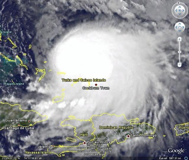
Center appears to be under the convection but we need more visible images.


You think the LLC is SE from the NHC tropical points under the deep convection?
0 likes   

jlauderdal
S2K Supporter
S2K Supporter
Posts: 7185
Joined: Wed May 19, 2004 5:46 am
Location: NE Fort Lauderdale
Contact:

Re:

#1829 Postby jlauderdal » Mon Sep 01, 2008 6:52 am

KWT wrote:Indeed Emmett what Hanna does today is key, I wonder whether it is starting the SW motion and this has allowed the system to get tucked up in the convection as the convection catches up from the west?

It looks around 55-60kts right now...


hey mate, you are in the wrong part of the world for hurricane tracking, for the amount of posting you do you need to be in the tropics.. :D
0 likes   

User avatar
KWT
Category 5
Category 5
Posts: 31415
Joined: Tue Aug 17, 2004 11:02 am
Location: UK!!!

#1830 Postby KWT » Mon Sep 01, 2008 6:58 am

jlauderdal, sort of but think where a good chunk of these systems, esp the recuvers end up heading... :D
That plus I do just enjoy tracking these beasts.

Blown_away, I think the circulation is on the NW side of the deep convection but its got to be stronger then 45kts now I'm sure.
0 likes   

User avatar
gatorcane
S2K Supporter
S2K Supporter
Posts: 23692
Age: 47
Joined: Sun Mar 13, 2005 3:54 pm
Location: Boca Raton, FL

Re: ATL: Tropical Storm Hanna in Western Atlantic

#1831 Postby gatorcane » Mon Sep 01, 2008 7:12 am

It's prudent not to concentrate on the line. It wouldn't take a left shift or a series of small left shifts here

NHC discussion snippet:

ALL INTERESTS IN FLORIDA SHOULD CLOSELY MONITOR THE FORECASTS FOR
HANNA SINCE ONLY A SLIGHT DEVIATION TO THE WEST OF THE OFFICIAL
TRACK COULD BRING THE CENTER OF HANNA MUCH CLOSER TO THE FLORIDA
EAST COAST AND THE BAHAMAS THAN CURRENTLY INDICATED.

http://www.nhc.noaa.gov/text/refresh/MI ... 0848.shtml
0 likes   

User avatar
sfwx
Category 1
Category 1
Posts: 371
Age: 59
Joined: Thu Sep 04, 2003 1:53 pm
Location: Rural St. Lucie County, Fl

Re: ATL: Tropical Storm Hanna in Western Atlantic

#1832 Postby sfwx » Mon Sep 01, 2008 7:13 am

http://www.crh.noaa.gov/product.php?sit ... glossary=1

AREA FORECAST DISCUSSION
NATIONAL WEATHER SERVICE MELBOURNE FL
414 AM EDT MON SEP 1 2008

.DISCUSSION...

...HIGH RIP CURRENT RISK AND DANGEROUS SURF TODAY...
...FORECAST OF HANNA REMAINS UNCERTAIN...


TUESDAY AND WEDNESDAY...FRESH EASTERLY FLOW CONTINUES WITH POPS A
LITTLE BELOW CLIMO WITH RELATIVELY DRY AIR ON NORTHWEST FRINGE OF
HANNA.
THURSDAY AND FRIDAY...ALL DEPENDS ON THE FUTURE TRACK AND INTENSITY
OF HANNA. GFDL NOGAPS AND UKMET MOVE HANNA FURTHER WEST THAN 00 UTC
GFS BUT HWRF IS FURTHER OFFSHORE. MOST MODELS DEVELOP HANNA INTO AT
LEAST A MINIMAL HURRICANE WHILE IT PASSES EAST CENTRAL FLORIDA. ALL
THINGS CONSIDERED THE CURRENT FORECAST IS BASED ON THE 00 UTC GFS
AND DAY 4-5 TPC FORECAST AND REFLECTS TROPICAL STORM CONDITIONS OVER
THE COASTAL WATERS ON THURSDAY WITH WINDS JUST BELOW TROPICAL STORM
FORCE ALONG THE COASTLINE. GFS REFLECTS INCREASING POPS EARLY
THURSDAY AS LIKELY RAINBANDS BEGIN AFFECTING COASTAL WATERS AND
COAST AND THEN GRADUALLY SPREAD OVER AREA DURING THE DAY THURSDAY.
IT IS IMPORTANT TO CONSIDER THAT THE FORECAST FOR HANNAH IS VERY
UNCERTAIN AT THIS POINT. THE POSSIBILITY OF CLOSE BRUSH WITH A
STRONG TROPICAL STORM OR A HURRICANE OR EVEN A LANDFALL ON THE
EAST CENTRAL FLORIDA COAST CAN NOT BE RULED OUT AT THIS TIME AS
THE ENTIRE AREA IS IN THE CONE OF UNCERTAINTY AND THE TRACK OF
HANNA IS FORECAST TO BE ABOUT 100 MILES EAST OF CAPE CANAVERAL
THURSDAY. THE MOST LIKELY SCENARIO IS A SIGNIFICANT MARINE AND
COASTAL EVENT WITH ROUGH SURF...
DANGEROUS RIP CURRENTS AND BEACH
EROSION. FUTURE FORECASTS COULD CHANGE CONSIDERABLY SO IT GOES
WITHOUT SAYING FOR ALL INTERESTS TO STAY TUNED TO LATEST FORECASTS
AND TPC ADVISORIES.

MOST MODELS MOVE HANNA OUT RAPIDLY ONCE IT TURNS NORTHWARD SO
CONDITIONS SHOULD BE IMPROVING SIGNIFICANTLY DURING THE DAY
FRIDAY WITH RIDGE OF HIGH PRESSURE BUILDING OVER THE WEEKEND.
&&

.AVIATION...MAINLY VFR EXPECTED. A LITTLE MORE HEATING THAN
.


SHORT TERM/AVIATION...LASCODY
LONG TERM....HAGEMEYER
0 likes   

User avatar
storms in NC
S2K Supporter
S2K Supporter
Posts: 2338
Joined: Thu Jul 28, 2005 2:58 pm
Location: Wallace,NC 40 miles NE of Wilm
Contact:

#1833 Postby storms in NC » Mon Sep 01, 2008 7:15 am

OT Every one is still on Gus. I have done both. I have WWL4 on so I can hear and watch what is going on. They got lucky. I am glad. They didn't need another Katrina.
He is now ashore some what.
Hanna is still sucking in bands from Gus. I think that is where alot her her energy is coming from.
0 likes   

User avatar
gatorcane
S2K Supporter
S2K Supporter
Posts: 23692
Age: 47
Joined: Sun Mar 13, 2005 3:54 pm
Location: Boca Raton, FL

#1834 Postby gatorcane » Mon Sep 01, 2008 7:16 am

well I wouldn't say sucking but wow Hanna has ramped up her convection in a hurry:

Image
0 likes   

User avatar
HURAKAN
Professional-Met
Professional-Met
Posts: 46086
Age: 38
Joined: Thu May 20, 2004 4:34 pm
Location: Key West, FL
Contact:

#1835 Postby HURAKAN » Mon Sep 01, 2008 7:17 am

Image

SHIP S 1100 20.60 -73.20 185 194 230 28.9 - - - - - 29.59
0 likes   

jlauderdal
S2K Supporter
S2K Supporter
Posts: 7185
Joined: Wed May 19, 2004 5:46 am
Location: NE Fort Lauderdale
Contact:

Re:

#1836 Postby jlauderdal » Mon Sep 01, 2008 7:17 am

KWT wrote:jlauderdal, sort of but think where a good chunk of these systems, esp the recuvers end up heading... :D
That plus I do just enjoy tracking these beasts.

Blown_away, I think the circulation is on the NW side of the deep convection but its got to be stronger then 45kts now I'm sure.


gale centers for you mate
0 likes   

tgenius
S2K Supporter
S2K Supporter
Posts: 1160
Joined: Mon May 15, 2006 5:31 pm
Location: Miami, FL

Re: ATL: Tropical Storm Hanna in Western Atlantic

#1837 Postby tgenius » Mon Sep 01, 2008 7:17 am

I posted in the models thread.. I think Hanna may pull a David in 1979 that went up the coast.
0 likes   

User avatar
Blown Away
S2K Supporter
S2K Supporter
Posts: 10156
Joined: Wed May 26, 2004 6:17 am

Re: ATL: Tropical Storm Hanna in Western Atlantic

#1838 Postby Blown Away » Mon Sep 01, 2008 7:18 am

gatorcane wrote:It's prudent not to concentrate on the line. It wouldn't take a left shift or a series of small left shifts here

NHC discussion snippet:

ALL INTERESTS IN FLORIDA SHOULD CLOSELY MONITOR THE FORECASTS FOR
HANNA SINCE ONLY A SLIGHT DEVIATION TO THE WEST OF THE OFFICIAL
TRACK COULD BRING THE CENTER OF HANNA MUCH CLOSER TO THE FLORIDA
EAST COAST AND THE BAHAMAS THAN CURRENTLY INDICATED.

http://www.nhc.noaa.gov/text/refresh/MI ... 0848.shtml


Especially since the models continue to shift S and most of the thinking is the ridge will be building W so there does not seem to be an escape for Hanna before hitting the CONUS at this point. Where have you been Gatorcane, I figured you would been all over this. :D
0 likes   

skufful
Tropical Storm
Tropical Storm
Posts: 244
Joined: Sat Nov 01, 2003 6:37 pm
Location: Beaufort, SC

Re: ATL: Tropical Storm Hanna in Western Atlantic

#1839 Postby skufful » Mon Sep 01, 2008 7:20 am

tgenius wrote:I posted in the models thread.. I think Hanna may pull a David in 1979 that went up the coast.


Wasn't too much of a storm, but no power for three weeks. Don't need that again.
0 likes   

caneman

Re: ATL: Tropical Storm Hanna in Western Atlantic

#1840 Postby caneman » Mon Sep 01, 2008 7:20 am

Blown_away wrote:
gatorcane wrote:It's prudent not to concentrate on the line. It wouldn't take a left shift or a series of small left shifts here

NHC discussion snippet:

ALL INTERESTS IN FLORIDA SHOULD CLOSELY MONITOR THE FORECASTS FOR
HANNA SINCE ONLY A SLIGHT DEVIATION TO THE WEST OF THE OFFICIAL
TRACK COULD BRING THE CENTER OF HANNA MUCH CLOSER TO THE FLORIDA
EAST COAST AND THE BAHAMAS THAN CURRENTLY INDICATED.

http://www.nhc.noaa.gov/text/refresh/MI ... 0848.shtml


Especially since the models continue to shift S and most of the thinking is the ridge will be building W so there does not seem to be an escape for Hanna before hitting the CONUS at this point. Where have you been Gatorcane, I figured you would been all over this. :D


Hannah is quickly taking center stage.
0 likes   


Return to “2008”

Who is online

Users browsing this forum: No registered users and 4 guests