


Tropical Depression Cristina in EPAC
Moderator: S2k Moderators
-
cycloneye

- Admin

- Posts: 149275
- Age: 69
- Joined: Thu Oct 10, 2002 10:54 am
- Location: San Juan, Puerto Rico
Re: EPAC: Invest 95E
WHXX01 KMIA 270047
CHGE77
TROPICAL CYCLONE GUIDANCE MESSAGE
NWS TPC/NATIONAL HURRICANE CENTER MIAMI FL
0047 UTC FRI JUN 27 2008
DISCLAIMER...NUMERICAL MODELS ARE SUBJECT TO LARGE ERRORS.
PLEASE REFER TO NHC OFFICIAL FORECASTS FOR TROPICAL CYCLONE
AND SUBTROPICAL CYCLONE INFORMATION.
EAST PACIFIC OBJECTIVE AIDS FOR
DISTURBANCE INVEST (EP952008) 20080627 0000 UTC
...00 HRS... ...12 HRS... ...24 HRS. .. ...36 HRS...
080627 0000 080627 1200 080628 0000 080628 1200
LAT LON LAT LON LAT LON LAT LON
BAMS 12.3N 120.1W 13.0N 121.8W 13.7N 123.6W 14.6N 125.3W
BAMD 12.3N 120.1W 12.9N 121.9W 13.6N 123.7W 14.2N 125.6W
BAMM 12.3N 120.1W 13.0N 121.8W 13.7N 123.6W 14.4N 125.2W
LBAR 12.3N 120.1W 13.0N 122.0W 14.2N 123.9W 15.5N 125.6W
SHIP 25KTS 32KTS 38KTS 44KTS
DSHP 25KTS 32KTS 38KTS 44KTS
...48 HRS... ...72 HRS... ...96 HRS. .. ..120 HRS...
080629 0000 080630 0000 080701 0000 080702 0000
LAT LON LAT LON LAT LON LAT LON
BAMS 15.6N 126.9W 17.9N 131.1W 20.8N 135.9W 24.2N 139.3W
BAMD 14.9N 127.6W 16.7N 132.4W 21.6N 136.7W 28.4N 135.4W
BAMM 15.2N 126.9W 17.2N 131.3W 21.0N 136.2W 25.9N 138.6W
LBAR 16.7N 127.2W 19.2N 130.2W 23.8N 133.2W 30.8N 130.7W
SHIP 46KTS 38KTS 23KTS 0KTS
DSHP 46KTS 38KTS 23KTS 0KTS
...INITIAL CONDITIONS...
LATCUR = 12.3N LONCUR = 120.1W DIRCUR = 290DEG SPDCUR = 10KT
LATM12 = 11.5N LONM12 = 118.4W DIRM12 = 290DEG SPDM12 = 10KT
LATM24 = 10.9N LONM24 = 116.3W
WNDCUR = 25KT RMAXWD = 45NM WNDM12 = 25KT
CENPRS = 1008MB OUTPRS = 1011MB OUTRAD = 120NM SDEPTH = D
RD34NE = 0NM RD34SE = 0NM RD34SW = 0NM RD34NW = 0NM
$$
0 likes


Re: EPAC: Invest 95E=TCFA issued
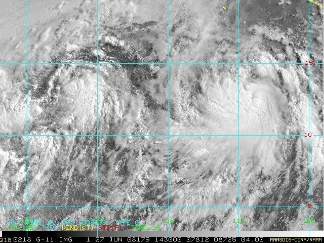
95E appears to be suffering from some dry air coming in from the NW and some upper-level shear from another system spinning SW of it. Development looks less likely here now.
0 likes

Re: EPAC: Invest 95E
It looks like it's trying to make a comeback now, with new convection developing around the center.
Here's the latest from NHC's TWO at 5am PDT:
A WESTWARD-MOVING AREA OF LOW PRESSURE IS LOCATED ABOUT 1000 MILES
SOUTHWEST OF THE SOUTHERN TIP OF BAJA CALIFORNIA. THIS SYSTEM
CONTINUES TO SHOW SIGNS OF ORGANIZATION AND IT COULD DEVELOP INTO A
TROPICAL DEPRESSION IN THE NEXT DAY OR SO BEFORE IT MOVES INTO AN
ENVIRONMENT LESS CONDUCIVE FOR DEVELOPMENT.
FORECASTER BEVEN
0 likes


-
HURAKAN

- Professional-Met

- Posts: 46084
- Age: 39
- Joined: Thu May 20, 2004 4:34 pm
- Location: Key West, FL
- Contact:
Re: EPAC: Invest 95E
TROPICAL WEATHER OUTLOOK
NWS TPC/NATIONAL HURRICANE CENTER MIAMI FL
1100 AM PDT FRI JUN 27 2008
FOR THE EASTERN NORTH PACIFIC...EAST OF 140 DEGREES WEST LONGITUDE..
THE NATIONAL HURRICANE CENTER IS ISSUING ADVISORIES ON
NEWLY-UPGRADED TROPICAL STORM BORIS...CENTERED ABOUT 555 MILES
SOUTHWEST OF MANZANILLO MEXICO.
AN AREA OF LOW PRESSURE LOCATED ABOUT 1050 MILES SOUTHWEST OF THE
SOUTHERN TIP OF BAJA CALIFORNIA IS MOVING WEST-NORTHWESTWARD. THE
ASSOCIATED SHOWER ACTIVITY HAS BECOME BETTER ORGANIZED THIS
MORNING. HOWEVER...SATELLITE SCATTEROMETER DATA INDICATE THE
SYSTEM DOES NOT YET HAVE A WELL-DEFINED CIRCULATION. THIS SYSTEM
COULD DEVELOP INTO A TROPICAL DEPRESSION AT ANY TIME DURING THE
NEXT DAY OR SO BEFORE IT MOVES INTO AN ENVIRONMENT LESS CONDUCIVE
FOR DEVELOPMENT.
ELSEWHERE...TROPICAL CYCLONE FORMATION IS NOT EXPECTED DURING THE
NEXT 48 HOURS.
0 likes
-
cycloneye
- Admin
- Posts: 149275
- Age: 69
- Joined: Thu Oct 10, 2002 10:54 am
- Location: San Juan, Puerto Rico
Re: EPAC: Invest 95E: Depression may form at any time
Depression at 2 PM PDT?
27/1800 UTC 13.6N 122.1W T2.5/2.5 95E -- East Pacific Ocean
27/1800 UTC 13.6N 122.1W T2.5/2.5 95E -- East Pacific Ocean
0 likes
Who is online
Users browsing this forum: No registered users and 198 guests