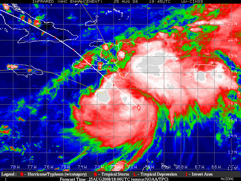
ATL GUSTAV: Tropical Depression - Discussion

Moderator: S2k Moderators

Message
Author
User avatar
ROCK
Category 5
Category 5
Posts: 9484
Age: 54
Joined: Tue Aug 17, 2004 7:30 am
Location: Kemah, Texas

Re: Re:

#2061 Postby ROCK » Mon Aug 25, 2008 9:20 pm

wxman57 wrote:
cpdaman wrote:
Dean4Storms wrote:Is it me or has Gustav really slowed down?


it's slowed down to a bit of a crawl over the last 2 hours


I measure about 10nm past 3 hours toward 302 deg. About 3-4 kts. Might be starting to feel the ridge to its northwest a bit early?


it seems that way....steering is tightening to his NW....precursor to a turn to wnw or w....you might be on to something with your Yucatan track earlier unless your thoughts have changed...
0 likes   

Stormcenter
S2K Supporter
S2K Supporter
Posts: 6684
Joined: Wed Sep 03, 2003 11:27 am
Location: Houston, TX

Re: ATL: Tropical Storm Gustav in Central Caribbean Sea

#2062 Postby Stormcenter » Mon Aug 25, 2008 9:22 pm

Ed Mahmoud wrote:Not much of a front, dewpoints in the mid to upper 60s behind it, and the winds are going light and Northeast behind it. I don't think that front will leave so much as just wash out.


Is this the front he is referring too?

This is an excerpt from the NWS out N.O. afternoon
discussion.

LONG TERM...

BY 00Z WED...THE WEAK FRONT FINALLY SLIDES SOUTH INTO CENTRAL
MISSISSIPPI AND NORTHERN LOUISIANA WHERE IT APPEARS TO WASH OUT.
HIGH PRESSURE WILL DOMINATE OUR WEATHER FOR A FEW DAYS WITH LOW
RAIN CHANCES. OUR REGION SHOULD RETURN TO MORE SEASONAL WEATHER WITH
CONSIDERABLY WARMER TEMPS AND MAINLY AFTERNOON SHOWERS. OUR NEXT
WEATHER MAKER WILL LIKELY BE A COLD FRONT THAT PUSHES INTO THE LOWER
MISSISSIPPI RIVER VALLEY OVER THE WEEKEND. UNCERTAINTY ASSOCIATED
WITH "GUSTAV" WILL ALSO BEAR WATCHING FOR THE LABOR DAY WEEKEND.
Last edited by Stormcenter on Mon Aug 25, 2008 9:22 pm, edited 1 time in total.
0 likes   

Ed Mahmoud

Re: ATL: Tropical Storm Gustav in Central Caribbean Sea

#2063 Postby Ed Mahmoud » Mon Aug 25, 2008 9:22 pm

Unless one is in the DR, Haiti, Cuba, Jamaica or the Caymans, no need to panic right this instant.

Don't know if Carl Arredondo is still on in NOLA, but I'd watch him if he was and I was there.
0 likes   

User avatar
wxman57
Moderator-Pro Met
Moderator-Pro Met
Posts: 22987
Age: 67
Joined: Sat Jun 21, 2003 8:06 pm
Location: Houston, TX (southwest)

Re: Re:

#2064 Postby wxman57 » Mon Aug 25, 2008 9:24 pm

ROCK wrote:
wxman57 wrote:I measure about 10nm past 3 hours toward 302 deg. About 3-4 kts. Might be starting to feel the ridge to its northwest a bit early?


it seems that way....steering is tightening to his NW....precursor to a turn to wnw or w....you might be on to something with your Yucatan track earlier unless your thoughts have changed...


Well, I changed my forecast from this morning as it looked like Gustav would get north of 20 and catch the weakness in the ridge to the north on Friday, taking it into the Gulf rather than continuing west to the Yucatan. Wouldn't rule out a Yucatan impact though. I think this is just a temporary slowdown as it organizes, though.
0 likes   

User avatar
gatorcane
S2K Supporter
S2K Supporter
Posts: 23692
Age: 47
Joined: Sun Mar 13, 2005 3:54 pm
Location: Boca Raton, FL

Re: ATL: Tropical Storm Gustav in Central Caribbean Sea

#2065 Postby gatorcane » Mon Aug 25, 2008 9:25 pm

Stormcenter wrote:
Ed Mahmoud wrote:Not much of a front, dewpoints in the mid to upper 60s behind it, and the winds are going light and Northeast behind it. I don't think that front will leave so much as just wash out.


Is this the front he is referring too?

This is an excerpt from the NWS out N.O. afternoon
discussion.

LONG TERM...

BY 00Z WED...THE WEAK FRONT FINALLY SLIDES SOUTH INTO CENTRAL
MISSISSIPPI AND NORTHERN LOUISIANA WHERE IT APPEARS TO WASH OUT.
HIGH PRESSURE WILL DOMINATE OUR WEATHER FOR A FEW DAYS WITH LOW
RAIN CHANCES. OUR REGION SHOULD RETURN TO MORE SEASONAL WEATHER WITH
CONSIDERABLY WARMER TEMPS AND MAINLY AFTERNOON SHOWERS. OUR NEXT
WEATHER MAKER WILL LIKELY BE A COLD FRONT THAT PUSHES INTO THE LOWER
MISSISSIPPI RIVER VALLEY OVER THE WEEKEND. UNCERTAINTY ASSOCIATED
WITH "GUSTAV" WILL ALSO BEAR WATCHING FOR THE LABOR DAY WEEKEND.


No that's not the one. There was one when you clicked "NCEP/NWS Fronts" on the NHC WV overlays but they must have just removed it within the past hour because I don't see it anymore...

and yes that is a High building in over Texas -- front has washed out it appears. My front talk is wrong then....
Last edited by gatorcane on Mon Aug 25, 2008 9:26 pm, edited 1 time in total.
0 likes   

mattpetre
Category 2
Category 2
Posts: 510
Age: 53
Joined: Mon Sep 19, 2005 3:20 pm
Location: Missouri City,TX & Galleria
Contact:

#2066 Postby mattpetre » Mon Aug 25, 2008 9:25 pm

I stick by Gustav missing Haiti (and I'm glad only Sanibel was willing to refute this.) I'm going to bed for the evening, but wouldn't be surprised to see a Cat 2 by tomorrow night before a possible brush with Jamaica. It's going to be a long weekend for all interests from Cancun all the way up to Pensacola... Best of luck to all.
0 likes   

Ed Mahmoud

Re: ATL: Tropical Storm Gustav in Central Caribbean Sea

#2067 Postby Ed Mahmoud » Mon Aug 25, 2008 9:26 pm

Stormcenter wrote:
Ed Mahmoud wrote:Not much of a front, dewpoints in the mid to upper 60s behind it, and the winds are going light and Northeast behind it. I don't think that front will leave so much as just wash out.


Is this the front he is referring too?

This is an excerpt from the NWS out N.O. afternoon
discussion.

LONG TERM...

BY 00Z WED...THE WEAK FRONT FINALLY SLIDES SOUTH INTO CENTRAL
MISSISSIPPI AND NORTHERN LOUISIANA WHERE IT APPEARS TO WASH OUT.
HIGH PRESSURE WILL DOMINATE OUR WEATHER FOR A FEW DAYS WITH LOW
RAIN CHANCES. OUR REGION SHOULD RETURN TO MORE SEASONAL WEATHER WITH
CONSIDERABLY WARMER TEMPS AND MAINLY AFTERNOON SHOWERS. OUR NEXT
WEATHER MAKER WILL LIKELY BE A COLD FRONT THAT PUSHES INTO THE LOWER
MISSISSIPPI RIVER VALLEY OVER THE WEEKEND. UNCERTAINTY ASSOCIATED
WITH "GUSTAV" WILL ALSO BEAR WATCHING FOR THE LABOR DAY WEEKEND.


HPC forecasts a front to the Gulf on Day 7. Next Thursday, that front is still well up in the Plains...

Image
0 likes   

User avatar
Blown Away
S2K Supporter
S2K Supporter
Posts: 10157
Joined: Wed May 26, 2004 6:17 am

Re: ATL: Tropical Storm Gustav in Central Caribbean Sea

#2068 Postby Blown Away » Mon Aug 25, 2008 9:26 pm

According to the NHC it will take Gus almost 5 days to move 10 degrees of longitude (71W to 81W), that is moving really slow and I think things could significantly change in 5 days. Gus not expected to make it to Key West's longitude until almost Sunday. IMO, the slow speed is why the NHC used strong uncertainty wording in the 5pm discussion.
0 likes   

User avatar
ROCK
Category 5
Category 5
Posts: 9484
Age: 54
Joined: Tue Aug 17, 2004 7:30 am
Location: Kemah, Texas

Re: Re:

#2069 Postby ROCK » Mon Aug 25, 2008 9:26 pm

wxman57 wrote:
ROCK wrote:
wxman57 wrote:I measure about 10nm past 3 hours toward 302 deg. About 3-4 kts. Might be starting to feel the ridge to its northwest a bit early?


it seems that way....steering is tightening to his NW....precursor to a turn to wnw or w....you might be on to something with your Yucatan track earlier unless your thoughts have changed...


Well, I changed my forecast from this morning as it looked like Gustav would get north of 20 and catch the weakness in the ridge to the north on Friday, taking it into the Gulf rather than continuing west to the Yucatan. Wouldn't rule out a Yucatan impact though. I think this is just a temporary slowdown as it organizes, though.


maybe so.....12Z CMC hinted at this possibility earlier today (Yucatan hit).....though Ed only sneezes at the CMC....... :lol:
0 likes   

User avatar
Portastorm
Storm2k Moderator
Storm2k Moderator
Posts: 9914
Age: 63
Joined: Fri Jul 11, 2003 9:16 am
Location: Round Rock, TX
Contact:

Re: ATL: Tropical Storm Gustav in Central Caribbean Sea

#2070 Postby Portastorm » Mon Aug 25, 2008 9:27 pm

We all know how difficult it is for the models to nail down intensity forecasts but does the same hold true for forecasts for windfield radii (i.e. HWRF and GFDL)? Just pondering how big ol' Gus might get before all is said and done.
0 likes   

Wx_Warrior
Category 5
Category 5
Posts: 2718
Joined: Thu Aug 03, 2006 3:58 pm
Location: Beaumont, TX

Re: ATL: Tropical Storm Gustav in Central Caribbean Sea

#2071 Postby Wx_Warrior » Mon Aug 25, 2008 9:28 pm

Gustav does have a good chance of once in the GOM of going west into So Tex/Mexico.
0 likes   

Frank P
S2K Supporter
S2K Supporter
Posts: 2776
Joined: Fri Aug 29, 2003 10:52 am
Location: Biloxi Beach, Ms
Contact:

Re: ATL: Tropical Storm Gustav in Central Caribbean Sea

#2072 Postby Frank P » Mon Aug 25, 2008 9:28 pm

Ed Mahmoud wrote:Unless one is in the DR, Haiti, Cuba, Jamaica or the Caymans, no need to panic right this instant.

Don't know if Carl Arredondo is still on in NOLA, but I'd watch him if he was and I was there.


Carl's still on WWL TV and radio. I heard him coming home from work.. he basically said lets wait and see what happens, mentioned it could get into the GOM or even go up the east coast ... not to overly concerned... yet..

I don't have any problem with Breck saying lets watch it... lord knows he blew Katrina stating it would never get into the GOM.. maybe he learned his lesson.. see if it does get into the GOM then worry... nothing is set in stone with these systems... models change, forecast change, intensity change.. its quite dynamic overall... prepare for the worst, hope for the best... and stay tuned
0 likes   

User avatar
LSU2001
S2K Supporter
S2K Supporter
Posts: 1711
Age: 57
Joined: Sat Sep 11, 2004 11:01 pm
Location: Cut Off, Louisiana

Re: ATL: Tropical Storm Gustav in Central Caribbean Sea

#2073 Postby LSU2001 » Mon Aug 25, 2008 9:29 pm

Ed Mahmoud wrote:Unless one is in the DR, Haiti, Cuba, Jamaica or the Caymans, no need to panic right this instant.

Don't know if Carl Arredondo is still on in NOLA, but I'd watch him if he was and I was there.


I do pay attention to Carl on Ch. 4 the wife had BB on the tube while I play on S2K, so I overheard the report. Let me be very, very clear, I know there is nothing to "panic" about now. I am not advocating overreaction. My concern is that many people do not pay close attention to the tropics, even on the coast. I talked to people today who thought Fay was still in the gulf :eek: . Those are the ones who could get confused and have the storm sneak up on them. Anyway enough about this personal rant. We need to get back on topic and I still haven't heard anyone say anything about the possible weakness left behind from Fay. Any thoughts would be appreciated.
Tim
0 likes   

User avatar
ConvergenceZone
Category 5
Category 5
Posts: 5194
Joined: Fri Jul 29, 2005 1:40 am
Location: Northern California

Re: Re:

#2074 Postby ConvergenceZone » Mon Aug 25, 2008 9:30 pm

wxman57 wrote:
ROCK wrote:
wxman57 wrote:I measure about 10nm past 3 hours toward 302 deg. About 3-4 kts. Might be starting to feel the ridge to its northwest a bit early?


it seems that way....steering is tightening to his NW....precursor to a turn to wnw or w....you might be on to something with your Yucatan track earlier unless your thoughts have changed...


Well, I changed my forecast from this morning as it looked like Gustav would get north of 20 and catch the weakness in the ridge to the north on Friday, taking it into the Gulf rather than continuing west to the Yucatan. Wouldn't rule out a Yucatan impact though. I think this is just a temporary slowdown as it organizes, though.


Hehe, seems like the forecasts are all over the place. When I was watching the weather tonight, just a few minutes ago, the MET mentioned that same exact thing. He said, he wouldn't be suprised at all if this turns shortly and goes directly into the Yukatan and dies there.....I kinda got in on the tail end of the discussion, but he mentioned it potentially bumping into the high pressure, slowing down and then gradually turning west north west and then west into the Yukatan.....So our buddies there need to watch this thing very carefully.....
0 likes   

User avatar
senorpepr
Military Met/Moderator
Posts: 12542
Age: 43
Joined: Fri Aug 22, 2003 9:22 pm
Location: Mackenbach, Germany
Contact:

Gustav WX Charts (LA/MS Charts added!)

#2075 Postby senorpepr » Mon Aug 25, 2008 9:31 pm

Charts produced hourly at :30
Ensure you refresh for the latest imagery


Tropical Storm Gustav (07L)

Surface Pressure and Plots
Image
Displayed is surface pressure (lines of equal pressure are displayed as blue lines) and surface plots. Click here for weather symbols explanation.

Surface Streamlines and Plots
Image
Displayed is surface wind (lines of equal wind direction are displayed as blue lines) and surface plots. Click here for weather symbols explanation.

Sea Surface Temperatures and Plots
Image
Displayed is sea surface temperatures.

Storm-specific Zoomed Surface Plots
Image
Displayed is surface plots, zoomed toward the storm. Click here for weather symbols explanation.


Charts produced every fifteen minutes at :05, :20, :35, :50
Ensure you refresh for the latest imagery

Louisiana, S Mississippi, and S Alabama Zoomed Surface Plots
Image

Louisiana, S Mississippi, and S Alabama Zoomed Surface Plots, Pressure, and 0.5° Base Reflectivity
Image

Louisiana, S Mississippi, and S Alabama Zoomed Surface Plots, Streamlines, and 0.5° Base Reflectivity
Image

Louisiana, S Mississippi, and S Alabama Zoomed Surface Plots, Streamlines, Pressure, and 0.5° Base Reflectivity
Image

Louisiana, S Mississippi, and S Alabama Zoomed Surface Plots and 0.5° Base Reflectivity
Image
0 likes   

User avatar
gatorcane
S2K Supporter
S2K Supporter
Posts: 23692
Age: 47
Joined: Sun Mar 13, 2005 3:54 pm
Location: Boca Raton, FL

#2076 Postby gatorcane » Mon Aug 25, 2008 9:32 pm

it certainly seems Gustav has slowed to a crawl..I'm thinking NHC will indicate an uncertain NW at about 8mph at this point although I see it even slower than that.
0 likes   

User avatar
ALhurricane
Professional-Met
Professional-Met
Posts: 452
Joined: Wed Jan 08, 2003 12:46 pm
Location: Daphne, AL

Re: ATL: Tropical Storm Gustav in Central Caribbean Sea

#2077 Postby ALhurricane » Mon Aug 25, 2008 9:35 pm

It appears to me that Gustav will very likely stay south of Cuba as it treks across the NW Caribbean. The trough to its north is about to leave Gustav behind with strong ridging developing in the trough's wake. I see no way but a turn to the west before it can get to the latitude. I would fully expect the NHC forecast to continue trending left with time.
0 likes   

User avatar
Ixolib
Category 5
Category 5
Posts: 2741
Age: 68
Joined: Sun Aug 08, 2004 8:55 pm
Location: Biloxi, MS

Re: ATL: Tropical Storm Gustav in Central Caribbean Sea

#2078 Postby Ixolib » Mon Aug 25, 2008 9:36 pm

LSU2001 wrote:I live in the 72 hour evac. zone...
Of course we all know how crazy that "72-hour" plan really is for coastal LA!! I wanna see how many folks down in Terrebonne, Lafourche, and Lower Plaquemines - not to mention the upper parishes - really heed that supposed plan...

I agree with the intent, but the reality will prove otherwise - regardless of a storm's given path 72 hours out.
0 likes   

O Town
S2K Supporter
S2K Supporter
Posts: 5205
Age: 52
Joined: Wed Sep 07, 2005 9:37 pm
Location: Orlando, Florida 28°35'35"N 81°22'55"W

#2079 Postby O Town » Mon Aug 25, 2008 9:39 pm

Image
0 likes   

User avatar
gatorcane
S2K Supporter
S2K Supporter
Posts: 23692
Age: 47
Joined: Sun Mar 13, 2005 3:54 pm
Location: Boca Raton, FL

#2080 Postby gatorcane » Mon Aug 25, 2008 9:39 pm

Is than an eye popping out again?

Image
0 likes   


Return to “2008”

Who is online

Users browsing this forum: No registered users and 5 guests