Why would that happen and what would that do to Ed?
Need you here Miami
ATL: Tropical Depression Edouard
Moderator: S2k Moderators
-
Bailey1777
- S2K Supporter

- Posts: 962
- Joined: Mon Jul 31, 2006 6:23 pm
- Location: Houston, Texas
-
HouTXmetro

- Category 5

- Posts: 3949
- Joined: Sun Jun 13, 2004 6:00 pm
- Location: District of Columbia, USA
Re:
Bailey1777 wrote:Why would that happen and what would that do to Ed?
I have no clue.... He showed the ULL to the W/SW then another small low really close just WNW of Eduoard.
0 likes
-
Extremeweatherguy

- Category 5
- Posts: 11095
- Joined: Mon Oct 10, 2005 8:13 pm
- Location: Florida
he said that it was a trough of low pressure that Edouard would follow toward Texas. I watched him too.
Last edited by Extremeweatherguy on Mon Aug 04, 2008 8:00 pm, edited 1 time in total.
0 likes
-
Shockwave
- Tropical Storm

- Posts: 167
- Joined: Fri Jul 25, 2008 7:33 am
- Location: Lafayette, TN
- Contact:
Re:
HouTXmetro wrote:Dr. Lyons said that an area of low pressure formed just to the NW of Edouard....
How does that happen when you have High Pressure that is keeping Ed from going north, but yet another low has formed?
0 likes
-
Bailey1777
- S2K Supporter
- Posts: 962
- Joined: Mon Jul 31, 2006 6:23 pm
- Location: Houston, Texas


-
wxman57

- Moderator-Pro Met

- Posts: 23172
- Age: 68
- Joined: Sat Jun 21, 2003 8:06 pm
- Location: Houston, TX (southwest)
Re: ATL: Tropical Storm Edouard - Gulf of Mexico
The center is a bit too far out to be seen easily by LCH radar. The center is about 133nm from LCH, so the radar beam is looking at an elevation of about 20,000 feet above the surface. What you see moving northwest is a band of squalls about 30nm north of the center. Pretty strong ridge to the north should keep it moving westward and at a somewhat faster pace. GFDL picks up the forward speed to over 10 kts tonight, bringing it inland early afternoon. Doesn't look too bad. May be interesting weather here in Houston tomorrow.
0 likes

Re: ATL: Tropical Storm Edouard - Gulf of Mexico
If anybody's interested, this is a shot of the stray feeder band that moved through here about an hour ago . View is looking roughly NW from a bridge on Dumaine St. over Bayou St. John looking back toward City Park/Lake Pontchartrain.

Hey, it's the only game in town right now.
Steve

Hey, it's the only game in town right now.
Steve
0 likes
-
wxman57
- Moderator-Pro Met
- Posts: 23172
- Age: 68
- Joined: Sat Jun 21, 2003 8:06 pm
- Location: Houston, TX (southwest)
Re:
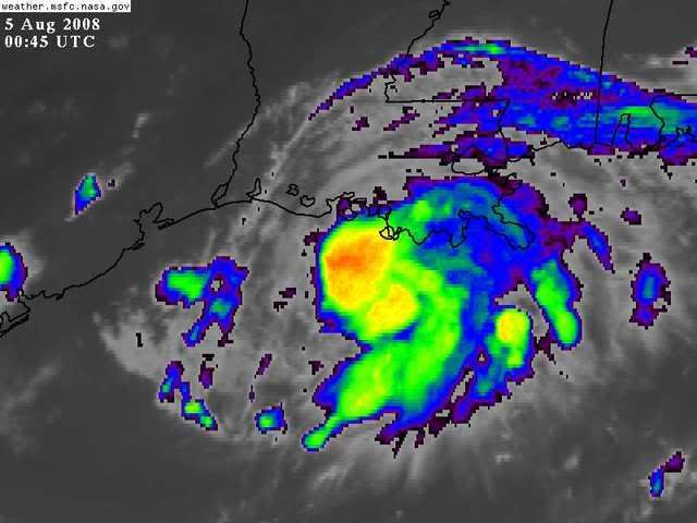
HURAKAN wrote:http://www.nrlmry.navy.mil/tcdat/tc08/ATL/05L.EDOUARD/ir/geo/1km/20080805.0045.goes12.x.ir1km.05LEDOUARD.45kts-999mb-284N-916W.100pc.jpg
http://i21.photobucket.com/albums/b300/ ... zaju6e.jpg
Strong convection over the center.
The center is south of that heavy convection.
0 likes
-
Bailey1777
- S2K Supporter
- Posts: 962
- Joined: Mon Jul 31, 2006 6:23 pm
- Location: Houston, Texas
-
Extremeweatherguy
- Category 5
- Posts: 11095
- Joined: Mon Oct 10, 2005 8:13 pm
- Location: Florida
Re: ATL: Tropical Storm Edouard - Gulf of Mexico
Thanks for the update wxman57. What do you think I will experience on the northern part of Galveston Island from this system?wxman57 wrote:The center is a bit too far out to be seen easily by LCH radar. The center is about 133nm from LCH, so the radar beam is looking at an elevation of about 20,000 feet above the surface. What you see moving northwest is a band of squalls about 30nm north of the center. Pretty strong ridge to the north should keep it moving westward and at a somewhat faster pace. GFDL picks up the forward speed to over 10 kts tonight, bringing it inland early afternoon. Doesn't look too bad. May be interesting weather here in Houston tomorrow.
0 likes

Re: ATL: Tropical Storm Edouard - Gulf of Mexico
RL3AO wrote:Normandy wrote:You guys are being fooled by radar, this storm isn't moving N or NE, I see a crawl to the W....The center is slowing down due to all the bursting convection over Ed....I'd say landfall time probably will need to be pushed back to noon tom. Remember folks, Ed is being steered by a dominant High to its north, it wont bust through that high and move N or NE. The path is very very straightforward.
It jogged to the north. Recon showed it with the VDM fixes. No big deal. Radar is not showing an illusion.

0 likes
Re: ATL: Tropical Storm Edouard - Gulf of Mexico
Dr. Lyons talking about how outflow is now 'choked' on all sides of the system...the outflow that looked like it was developing on the south and east sides has stopped so it is going to have rely on internal mechanisms only if it is going to strengthen much
0 likes
-
wxman57
- Moderator-Pro Met
- Posts: 23172
- Age: 68
- Joined: Sat Jun 21, 2003 8:06 pm
- Location: Houston, TX (southwest)
Re:
Bailey1777 wrote:Looks that way Wxman57, can you chime in on the low they are talking about please.
I have no idea what they're talking about. Looks like a strengthening TS to me, moving toward the west to west-northwest.
0 likes
-
HouTXmetro
- Category 5
- Posts: 3949
- Joined: Sun Jun 13, 2004 6:00 pm
- Location: District of Columbia, USA
-
Extremeweatherguy
- Category 5
- Posts: 11095
- Joined: Mon Oct 10, 2005 8:13 pm
- Location: Florida
Re: ATL: Tropical Storm Edouard - Gulf of Mexico
I just watched Lyons again too. He said he expects the storm to follow the trough of low pressure into the TX coast and possibly reach Cat. 1 strength by landfall. He also stressed that the area of greatest impact will be confined to a small region near where this makes landfall.jinftl wrote:Dr. Lyons talking about how outflow is now 'choked' on all sides of the system...the outflow that looked like it was developing on the south and east sides has stopped so it is going to have rely on internal mechanisms only if it is going to strengthen much
0 likes
-
Bailey1777
- S2K Supporter
- Posts: 962
- Joined: Mon Jul 31, 2006 6:23 pm
- Location: Houston, Texas
-
Sean in New Orleans

- Category 5
- Posts: 1794
- Joined: Thu Aug 28, 2003 7:26 pm
- Location: New Orleans, LA 30.0N 90.0W
- Contact:
Re: ATL: Tropical Storm Edouard - Gulf of Mexico
Extremeweatherguy wrote:Thanks for the update wxman57. What do you think I will experience on the northern part of Galveston Island from this system?wxman57 wrote:The center is a bit too far out to be seen easily by LCH radar. The center is about 133nm from LCH, so the radar beam is looking at an elevation of about 20,000 feet above the surface. What you see moving northwest is a band of squalls about 30nm north of the center. Pretty strong ridge to the north should keep it moving westward and at a somewhat faster pace. GFDL picks up the forward speed to over 10 kts tonight, bringing it inland early afternoon. Doesn't look too bad. May be interesting weather here in Houston tomorrow.
I doubt the weather will be particularly interesting, but, it will probably rain some. This system is pretty small, IMO.
0 likes
-
HouTXmetro
- Category 5
- Posts: 3949
- Joined: Sun Jun 13, 2004 6:00 pm
- Location: District of Columbia, USA
Re: Re:
wxman57 wrote:Bailey1777 wrote:Looks that way Wxman57, can you chime in on the low they are talking about please.
I have no idea what they're talking about. Looks like a strengthening TS to me, moving toward the west to west-northwest.
Dr Lyons said Ed was following a trough that developed aroun him into the upper TX coast and that another center reformation further west was possible.
0 likes
-
Stormcenter
- S2K Supporter
- Posts: 6689
- Joined: Wed Sep 03, 2003 11:27 am
- Location: Houston, TX
I think everyone is over analyzing Eddie. He is has definitely been moving erractically. The NHC noted this in their latest advisory. To say otherwise is contradicting them.
Last edited by Stormcenter on Mon Aug 04, 2008 8:13 pm, edited 1 time in total.
0 likes
Who is online
Users browsing this forum: No registered users and 54 guests