ATL GUSTAV: Tropical Depression - Discussion

Moderator: S2k Moderators

Message
Author
Matt-hurricanewatcher

Re: Re:

#2281 Postby Matt-hurricanewatcher » Tue Aug 26, 2008 1:35 am

artist wrote:
nolecaster wrote:
PTrackerLA wrote:
Wow, less than 24 hours ago we had an INVEST. INSANE!


Pretty crazy when you think about it. At this rate, I wonder what the total amount of intensification will be by 11 AM with his first advisory as a TD being yesterday at 11 AM.


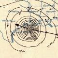
recon reported that the radar is showing greatest intensity in the ne quad. I wonder what they will find there.


It would not suprize me if there is some 90 knot flight level winds in the northeast quad. If this has enough time over the super hot waters I expect this to become a very powerful hurricane.
0 likes   

User avatar
lamsalfl
Tropical Depression
Tropical Depression
Posts: 79
Age: 42
Joined: Thu Aug 16, 2007 1:46 am
Location: New Orleans, LA

#2282 Postby lamsalfl » Tue Aug 26, 2008 1:36 am

Tell me why this couldn't grow to a Cat 3 before it approaches SE Cuba. :double:
0 likes   

Aric Dunn
Category 5
Category 5
Posts: 21238
Age: 42
Joined: Sun Sep 19, 2004 9:58 pm
Location: Ready for the Chase.
Contact:

Re:

#2283 Postby Aric Dunn » Tue Aug 26, 2008 1:37 am

lamsalfl wrote:Tell me why this couldn't grow to a Cat 3 before it approaches SE Cuba. :double:


its likely at this point
0 likes   

Matt-hurricanewatcher

Re:

#2284 Postby Matt-hurricanewatcher » Tue Aug 26, 2008 1:38 am

lamsalfl wrote:Tell me why this couldn't grow to a Cat 3 before it approaches SE Cuba. :double:


Hati
0 likes   

User avatar
Normandy
Category 5
Category 5
Posts: 2293
Joined: Sun Oct 10, 2004 12:31 am
Location: Houston, TX

Re: ATL: Hurricane Gustav in Central Caribbean Sea

#2285 Postby Normandy » Tue Aug 26, 2008 1:38 am

FWIW, Hurricane Gustav now holds the record Humberto set last year for fastest deepening. Humberto went from TD to cane in 19 hours, this went from TD to cane in 14 hours. Although this probably was a TD before the NHC classified it.
0 likes   

User avatar
artist
Category 5
Category 5
Posts: 9792
Joined: Mon Jun 06, 2005 3:26 pm
Location: West Palm

Re: Re:

#2286 Postby artist » Tue Aug 26, 2008 1:39 am

Matt-hurricanewatcher wrote:quote]

It would not suprize me if there is some 90 knot flight level winds in the northeast quad. If this has enough time over the super hot waters I expect this to become a very powerful hurricane.

that is my fear Matt, good to see you!
0 likes   

RL3AO
Moderator-Pro Met
Moderator-Pro Met
Posts: 16308
Joined: Thu Jun 14, 2007 10:03 pm
Location: NC

Re: ATL: Hurricane Gustav in Central Caribbean Sea

#2287 Postby RL3AO » Tue Aug 26, 2008 1:39 am

Normandy wrote:FWIW, Hurricane Gustav now holds the record Humberto set last year for fastest deepening. Humberto went from TD to cane in 19 hours, this went from TD to cane in 14 hours. Although this probably was a TD before the NHC classified it.


Best track has already been changed to a TD at 6z yesterday. So the best track will be TD to hurricane between 18 and 24 hours.
0 likes   

User avatar
artist
Category 5
Category 5
Posts: 9792
Joined: Mon Jun 06, 2005 3:26 pm
Location: West Palm

Re: ATL: Hurricane Gustav in Central Caribbean Sea

#2288 Postby artist » Tue Aug 26, 2008 1:44 am

what is up with the GOES satellite? It has been having problems all afternoon and tonight as well. from ghcc
0 likes   

RL3AO
Moderator-Pro Met
Moderator-Pro Met
Posts: 16308
Joined: Thu Jun 14, 2007 10:03 pm
Location: NC

Re: ATL: Hurricane Gustav in Central Caribbean Sea

#2289 Postby RL3AO » Tue Aug 26, 2008 1:45 am

artist wrote:what is up with the GOES satellite? It has been having problems all afternoon and tonight as well. from ghcc


It was in the eclipse which explains tonights issues.
0 likes   

User avatar
artist
Category 5
Category 5
Posts: 9792
Joined: Mon Jun 06, 2005 3:26 pm
Location: West Palm

#2290 Postby artist » Tue Aug 26, 2008 1:47 am

thanks. It is showing black spots all over it as well. Hopefully later today it will be fixed.
0 likes   

User avatar
lamsalfl
Tropical Depression
Tropical Depression
Posts: 79
Age: 42
Joined: Thu Aug 16, 2007 1:46 am
Location: New Orleans, LA

#2291 Postby lamsalfl » Tue Aug 26, 2008 1:48 am

http://en.wikipedia.org/wiki/Hurricane_Gustav_(2008)

Wikipedia is exponetially fast!!!
0 likes   

User avatar
lamsalfl
Tropical Depression
Tropical Depression
Posts: 79
Age: 42
Joined: Thu Aug 16, 2007 1:46 am
Location: New Orleans, LA

#2292 Postby lamsalfl » Tue Aug 26, 2008 1:52 am

Wow... If the storm doesn't hit eastern Cuba at all, I wonder how much the proximity would affect further development.

Image
0 likes   

User avatar
Hurricanewatcher2007
Category 2
Category 2
Posts: 578
Joined: Sat Jul 05, 2008 8:10 pm

Re:

#2293 Postby Hurricanewatcher2007 » Tue Aug 26, 2008 2:02 am

lamsalfl wrote:Wow... If the storm doesn't hit eastern Cuba at all, I wonder how much the proximity would affect further development.

Image


In the short term it might slow down development but the "mountains" aren't high enough in that part of Cuba to disrupt the circulation at all if it doesn't even make landfall. Once away and in the Gulf it should resume development depending on environmental conditions in the Gulf at the time.
0 likes   

User avatar
lost cause
Tropical Low
Tropical Low
Posts: 24
Age: 48
Joined: Thu Aug 24, 2006 6:24 pm
Location: Galveston

Re:

#2294 Postby lost cause » Tue Aug 26, 2008 2:10 am

lamsalfl wrote:Wow... If the storm doesn't hit eastern Cuba at all, I wonder how much the proximity would affect further development.

Image


I was looking at the water vapor loop on NHC today and had this sinking feeling that the forecast track that was posted initially was a little too optimistic on the right hand drift of Gustav. Now, the models are more in line with what the WVLoop was showing. Now, it's entirely likely this system will hit the loop current in the Yucatan Channel. Greeeeat. :roll: Just what this monster-in-the-wings needs: fuel.
0 likes   

User avatar
lamsalfl
Tropical Depression
Tropical Depression
Posts: 79
Age: 42
Joined: Thu Aug 16, 2007 1:46 am
Location: New Orleans, LA

#2295 Postby lamsalfl » Tue Aug 26, 2008 2:11 am

Pardon my ignorance. What is "the loop"?
0 likes   

Aric Dunn
Category 5
Category 5
Posts: 21238
Age: 42
Joined: Sun Sep 19, 2004 9:58 pm
Location: Ready for the Chase.
Contact:

Re: ATL: Hurricane Gustav in Central Caribbean Sea

#2296 Postby Aric Dunn » Tue Aug 26, 2008 2:14 am

finally..

and image and there is a an eye popping out with deep convection all around it..

Image
0 likes   

User avatar
artist
Category 5
Category 5
Posts: 9792
Joined: Mon Jun 06, 2005 3:26 pm
Location: West Palm

#2297 Postby artist » Tue Aug 26, 2008 2:15 am

Loop Current
From Wikipedia, the free encyclopedia
Jump to: navigation, search

Gulf Stream currents (1943 map).Part of the Gulf Stream, the Loop Current is a warm ocean current in the Gulf of Mexico that flows northward between Cuba and the Yucatán peninsula, moves north into the Gulf of Mexico, loops west and south before exiting to the east through the Florida Straits.

A related feature is an area of warm water called an "Eddy" or "Loop Current ring" that separates from the Loop Current, somewhat randomly. These rings then drift to the west at speeds of about 5 cm/s (0.18 km/h or 0.11 mph) and bump into the coast of Texas or Mexico.

http://en.wikipedia.org/wiki/Loop_Current

I should have added that this current can strengthen a hurricane if it sits over it due to the heat of the water.
Last edited by artist on Tue Aug 26, 2008 2:18 am, edited 1 time in total.
0 likes   

User avatar
artist
Category 5
Category 5
Posts: 9792
Joined: Mon Jun 06, 2005 3:26 pm
Location: West Palm

Re: ATL: Hurricane Gustav in Central Caribbean Sea

#2298 Postby artist » Tue Aug 26, 2008 2:17 am

Aric Dunn wrote:finally..

and image and there is a an eye popping out with deep convection all around it..


not fair Aric! :grr: It is still showing black for me!
0 likes   

Aric Dunn
Category 5
Category 5
Posts: 21238
Age: 42
Joined: Sun Sep 19, 2004 9:58 pm
Location: Ready for the Chase.
Contact:

Re: ATL: Hurricane Gustav in Central Caribbean Sea

#2299 Postby Aric Dunn » Tue Aug 26, 2008 2:18 am

artist wrote:
Aric Dunn wrote:finally..

and image and there is a an eye popping out with deep convection all around it..


not fair Aric! :grr: It is still showing black for me!

use this site..
http://weather.msfc.nasa.gov/GOES/goeseastconusir.html
it updates normally every 10 to 15 minutes
0 likes   

User avatar
artist
Category 5
Category 5
Posts: 9792
Joined: Mon Jun 06, 2005 3:26 pm
Location: West Palm

#2300 Postby artist » Tue Aug 26, 2008 2:19 am

I used to have that link and lost it! Thanks!
0 likes   


Return to “2008”

Who is online

Users browsing this forum: No registered users and 21 guests