ATL GUSTAV: Tropical Depression - Discussion
Moderator: S2k Moderators


-
cheezyWXguy

- Category 5

- Posts: 6281
- Joined: Mon Feb 13, 2006 12:29 am
- Location: Dallas, TX
Re:
HURAKAN wrote:
The convective burst will likely poof later on tonight but it keeps the disturbance alive for the time being.
The burst will likely die out, only to be replaced by another, as the dmax occurs at night. You know, it does look a lot better today than it did at this time yesterday..
0 likes
-
cycloneye

- Admin

- Posts: 149276
- Age: 69
- Joined: Thu Oct 10, 2002 10:54 am
- Location: San Juan, Puerto Rico
Re: ATL: Invest 94L in East Atlantic
ABNT20 KNHC 192332
TWOAT
TROPICAL WEATHER OUTLOOK
NWS TPC/NATIONAL HURRICANE CENTER MIAMI FL
800 PM EDT TUE AUG 19 2008
FOR THE NORTH ATLANTIC...CARIBBEAN SEA AND THE GULF OF MEXICO...
THE NATIONAL HURRICANE CENTER IS ISSUING ADVISORIES ON TROPICAL
STORM FAY...CENTERED INLAND OVER FLORIDA 45 MILES SOUTH-SOUTHWEST OF
MELBOURNE.
 AN AREA OF LOW PRESSURE LOCATED ABOUT 950 MILES WEST-SOUTHWEST OF
THE CAPE VERDE ISLANDS HAS CHANGED LITTLE IN ORGANIZATION THIS
EVENING. ALTHOUGH ENVIRONMENTAL CONDITIONS ARE ONLY MARGINALLY
FAVORABLE...SOME DEVELOPMENT OF THIS SYSTEM IS POSSIBLE OVER THE
NEXT COUPLE OF DAYS AS IT MOVES TO THE WEST OR WEST-NORTHWEST NEAR
15 MPH.
ELSEWHERE...TROPICAL CYCLONE FORMATION IS NOT EXPECTED DURING THE
NEXT 48 HOURS.
$$
FORECASTER RHOME
TWOAT
TROPICAL WEATHER OUTLOOK
NWS TPC/NATIONAL HURRICANE CENTER MIAMI FL
800 PM EDT TUE AUG 19 2008
FOR THE NORTH ATLANTIC...CARIBBEAN SEA AND THE GULF OF MEXICO...
THE NATIONAL HURRICANE CENTER IS ISSUING ADVISORIES ON TROPICAL
STORM FAY...CENTERED INLAND OVER FLORIDA 45 MILES SOUTH-SOUTHWEST OF
MELBOURNE.
THE CAPE VERDE ISLANDS HAS CHANGED LITTLE IN ORGANIZATION THIS
EVENING. ALTHOUGH ENVIRONMENTAL CONDITIONS ARE ONLY MARGINALLY
FAVORABLE...SOME DEVELOPMENT OF THIS SYSTEM IS POSSIBLE OVER THE
NEXT COUPLE OF DAYS AS IT MOVES TO THE WEST OR WEST-NORTHWEST NEAR
15 MPH.
ELSEWHERE...TROPICAL CYCLONE FORMATION IS NOT EXPECTED DURING THE
NEXT 48 HOURS.
$$
FORECASTER RHOME
0 likes
-
Matt-hurricanewatcher
Re:
CrazyC83 wrote:And the NHC continues to be really conservative on this. Maybe they are too busy eating crow as a result of Fay?
They knocked fay out of the park with forecasting it. They did a great job.
I agree with this, I believe it has a closed LLC in if shear don't destroy it will be our next cyclone. In about 84-96 hours when Fay is finally dead over the southeastern United states, I believe this we will be watching.
0 likes

Re:
CrazyC83 wrote:And the NHC continues to be really conservative on this. Maybe they are too busy eating crow as a result of Fay?
UM WHAT?
http://www.nhc.noaa.gov/archive/2008/graphics/al06/loop_5W.shtml
0 likes
-
cycloneye
- Admin
- Posts: 149276
- Age: 69
- Joined: Thu Oct 10, 2002 10:54 am
- Location: San Juan, Puerto Rico
Re: ATL: Invest 94L in East Atlantic
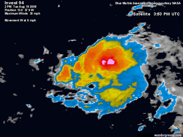
00:00 UTC Best Track for 94L:
AL, 94, 2008082000, , BEST, 0, 127N, 384W, 25, 1007, DB, 34, NEQ, 0, 0, 0, 0, 1010, 150, 45,
AL, 94, 2008082000, , BEST, 0, 127N, 384W, 25, 1007, DB, 34, NEQ, 0, 0, 0, 0, 1010, 150, 45,
0 likes
-
cheezyWXguy
- Category 5
- Posts: 6281
- Joined: Mon Feb 13, 2006 12:29 am
- Location: Dallas, TX
Re:
KWT wrote:Yep Matt very likely, steering currents suggests that if this stays weak should be a threat to land if it does develop, be it the Caribbean or the east coast of the states, with such a large high in the Atlantic right now hard to see it fishing...
yeah in about 36 hours or less, conditions should be sufficient to produce a td. However, more complicated is where it goes when it develops.
0 likes
-
cycloneye
- Admin
- Posts: 149276
- Age: 69
- Joined: Thu Oct 10, 2002 10:54 am
- Location: San Juan, Puerto Rico
Re: ATL: Invest 94L in East Atlantic
19/2345 UTC 12.9N 38.2W T1.0/1.0 94L -- Atlantic Ocean
http://www.ssd.noaa.gov/PS/TROP/positions.html
http://www.ssd.noaa.gov/PS/TROP/positions.html
0 likes

Re:
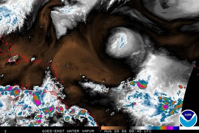
KWT wrote:The thing is Patrick the models haven't exactly done much good recently with the upper set-up, the ULL is digging but if the track stays far enough south then any shear won't last long as the ULL will eventually lift I'd imagine/
May have to eat my words. It looks better now than it did.
When is the ULL expected to lift a bit and relax the shear? We've seen better systems than this severely disrupted by ULLs in the wrong place at the wrong time.
0 likes
-
lonelymike
- S2K Supporter

- Posts: 634
- Joined: Sat Jul 26, 2008 10:12 am
- Location: walton county fla
Re:
CrazyC83 wrote:And the NHC continues to be really conservative on this. Maybe they are too busy eating crow as a result of Fay?
Actually I think they have done a pretty darn good job with Fay. What's your damage with them?
0 likes
Re: ATL: Invest 94L in Central Atlantic
It's acting like a survivor but is also about to face a huge ULL ripsaw. Doesn't look strong enough to survive that - but who knows?
0 likes
-
cycloneye
- Admin
- Posts: 149276
- Age: 69
- Joined: Thu Oct 10, 2002 10:54 am
- Location: San Juan, Puerto Rico
Re: ATL: Invest 94L in Central Atlantic
It has mantained convection during dimin,now lets see when DMAX comes,if it increases more than what it shows now.

0 likes
-
cheezyWXguy
- Category 5
- Posts: 6281
- Joined: Mon Feb 13, 2006 12:29 am
- Location: Dallas, TX
Re: ATL: Invest 94L in Central Atlantic
cycloneye wrote:It has mantained convection during dimin,now lets see when DMAX comes,if it increases more than what it shows now.
Looks like a pretty hefty burst on the west side...it may get absorbed into the circulation, allowing it to organize, in addition to new convection likely to pop later on tonight. And Sanibel, Shear is marginal right now, but shear is no longer forecast to be very bad for the next 5 days..infact at 11kt or less. Shear should decrease within the next 24 hours, allowing the storm to strengthen. Its not bad now anyway, but the main impedent over the next 2 days will likely be dry air.
0 likes
Who is online
Users browsing this forum: Google Adsense [Bot] and 136 guests