I don't thik that's an EWRC
Just looks like an intense eyewall on my GARP station
TC Bertha
Moderator: S2k Moderators


-
Derek Ortt
-
CajunMama
- Retired Staff

- Posts: 10791
- Joined: Thu Feb 06, 2003 9:57 pm
- Location: 30.22N, 92.05W Lafayette, LA
Re: Hurricane Bertha in Central Atlantic
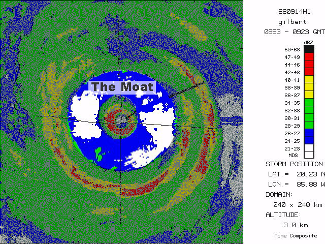
cycloneye wrote:57,what is a moat?
I'm not wxman57 but i remember seeing this on a page i found
The term "moat" usually refers to the region between the eyewall and an outer rainband, such as a secondary eyewall rainband (see the image above). The moat is the relatively light rain region between the rainband and the eyewall.
FAQ's about hurricanes
0 likes
Re: Hurricane Bertha in Central Atlantic
cycloneye wrote:57,what is a moat?
I posted a link to this MIMIC imagery a few days ago and thought it worthwhile to post again given the ERC conversation here.. It shows Ivan going through an ERC for those who wnat to know more. You'll see a secondary eyewall form, along with a moat (a ring caused by subsidence that forms between the inner and outer eyewalls). Then you'll see the inner eyewall collapse and the outer eyewall contract to take its place.
http://cimss.ssec.wisc.edu/tropic/real- ... ivan1.html
0 likes


-
cycloneye

- Admin

- Posts: 149291
- Age: 69
- Joined: Thu Oct 10, 2002 10:54 am
- Location: San Juan, Puerto Rico
Re: Hurricane Bertha in Central Atlantic
CajunMama wrote:cycloneye wrote:57,what is a moat?
I'm not wxman57 but i remember seeing this on a page i found
The term "moat" usually refers to the region between the eyewall and an outer rainband, such as a secondary eyewall rainband (see the image above). The moat is the relatively light rain region between the rainband and the eyewall.
FAQ's about hurricanes
Thanks CM,I got all of what I wanted to know there and more as answers came in a row.
0 likes


Re: Hurricane Bertha in Central Atlantic
WOW - What an amazing storm to track!!!!!
Also - what an amazing board to learn about TCs - I'm as impressed by the 160+ pages of discussion (to date) on this storm as I am by the storm itself - THANK YOU TO ALL!
Also - what an amazing board to learn about TCs - I'm as impressed by the 160+ pages of discussion (to date) on this storm as I am by the storm itself - THANK YOU TO ALL!
0 likes
-
weatherguru18
Re: Hurricane Bertha in Central Atlantic
A good indication of direction is to watch the direction of the clouds blowing off. Notice that the clouds being vented are being pulled north. She's (forgot the terminology--what Isabel was) on the south side and 'top heavy' on the northside.
http://www.goes.noaa.gov/HURRLOOPS/huirloop.html
http://www.goes.noaa.gov/HURRLOOPS/huirloop.html
0 likes
-
Matt-hurricanewatcher
Re: Hurricane Bertha in Central Atlantic
I say borderline cat2/3 right now.
I say thank god for storm2k. I don't know what I do with out it!
I say thank god for storm2k. I don't know what I do with out it!
0 likes
-
HURAKAN

- Professional-Met

- Posts: 46084
- Age: 39
- Joined: Thu May 20, 2004 4:34 pm
- Location: Key West, FL
- Contact:
2008JUL09 204500 5.4 961.8/ -0.2 / 99.6 5.4 5.4 5.4 NO LIMIT OFF OFF 4.24 -56.23 EYE 16 IR 24.93 58.13 COMBO
2008JUL09 211500 5.4 961.8/ -0.2 / 99.6 5.4 5.4 5.4 NO LIMIT OFF OFF 5.54 -56.33 EYE 18 IR 24.97 58.18 COMBO
2008JUL09 214500 5.4 961.8/ -0.2 / 99.6 5.4 5.4 5.4 NO LIMIT OFF OFF 12.54 -55.37 EYE 21 IR 25.02 58.35 COMBO
2008JUL09 221500 5.4 961.8/ -0.2 / 99.6 5.4 5.1 5.1 NO LIMIT OFF OFF 11.84 -52.83 EYE 22 IR 24.97 58.29 COMBO
_____________
Constant for the last hour and a half.
0 likes
-
weatherguru18
Re: Hurricane Bertha in Central Atlantic
Can somebody help me out with terminology? I can't think of what a hurricane is called when there isn't very many clouds being vented off. Very clean cut so to speak. The only hurricane I can think of is Isabel...it was Isabel right? It's going to drive me crazy!
0 likes

I think NHC will probably upgrade to category-3, its close enough now to warrant it being upgraded IMO. Also still looks pretty good though I'd imagine it must be getting close to her peak right now given the heat content in the region.
gotoman38, yep for all these long trackers you tend to find these threads get close to if not above 100 pages long, esp when there is a threat to the USA.
gotoman38, yep for all these long trackers you tend to find these threads get close to if not above 100 pages long, esp when there is a threat to the USA.
0 likes
-
srainhoutx

- S2K Supporter

- Posts: 6919
- Age: 68
- Joined: Sun Jan 14, 2007 11:34 am
- Location: Haywood County, NC
- Contact:
Re: Hurricane Bertha in Central Atlantic
Great job folks. Sure looks good from a distance, doesn't it. 
0 likes
Who is online
Users browsing this forum: No registered users and 12 guests