

brunota2003 wrote:That inner eyewall just does not want to give up, does it? Keeping the storm weaker and keeping it from organizing, which is both good and bad.
Indeed. This is the eyewall replacement cycle that never ends!
Moderator: S2k Moderators
brunota2003 wrote:That inner eyewall just does not want to give up, does it? Keeping the storm weaker and keeping it from organizing, which is both good and bad.


ggg wrote:this is annular...it will not undergo anymore eyewall replacement cycles while annular. It will also resist weakening in a hostile environment.

ggg wrote:this is annular...it will not undergo anymore eyewall replacement cycles while annular. It will also resist weakening in a hostile environment.
MiamiensisWx wrote:It appears that the center (wind center?) is still moving NW. Long term movement has remained NW as well.
http://www.ssd.noaa.gov/goes/flt/t1/loop-vis.html
TS Warning may be eventually warranted for Bermuda, especially when the large TS wind radii is taken into considerations.


HURAKAN wrote:Another possible record:
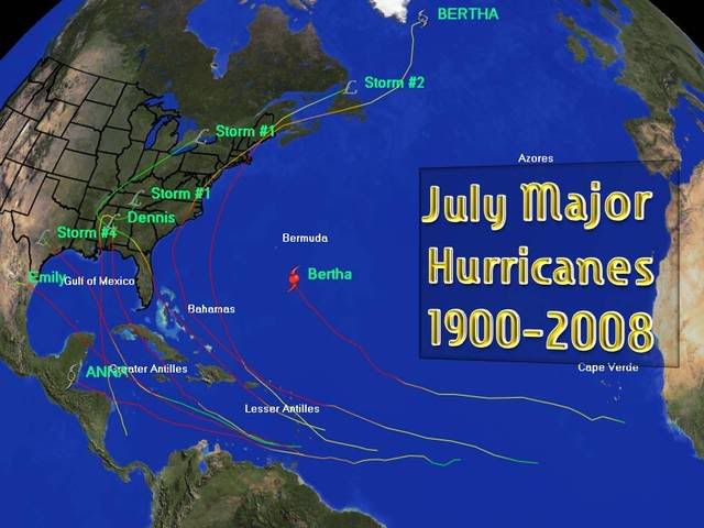
Using "Eye of the Storm" I found nine major hurricanes in the month of July. Storm #4 1909, Storm #1 1916, Storm #2 1916, Storm #1 1926, Anna 1961, Bertha 1996, Dennis 2005, Emily 2005, & Bertha 2008. But I wanted to find which went faster from hurricane to major hurricane and Bertha 2008 takes the flag with just 12 hours. Can anyone confirm this?
Chacor wrote:## ANNULAR HURRICANE INDEX (AHI) AL022008 BERTHA 07/12/08 00 UTC ##
## STORM NOT ANNULAR, SCREENING STEP FAILED, NPASS=6 NFAIL=1 ##
## AHI= 0 (AHI OF 100 IS BEST FIT TO ANN. STRUC., 1 IS MARGINAL, 0 IS NOT ANNULAR) ##
## ANNULAR INDEX RAN NORMALLY
ggg wrote:Chacor wrote:## ANNULAR HURRICANE INDEX (AHI) AL022008 BERTHA 07/12/08 00 UTC ##
## STORM NOT ANNULAR, SCREENING STEP FAILED, NPASS=6 NFAIL=1 ##
## AHI= 0 (AHI OF 100 IS BEST FIT TO ANN. STRUC., 1 IS MARGINAL, 0 IS NOT ANNULAR) ##
## ANNULAR INDEX RAN NORMALLY
Don't be fooled. This is an annular hurricane. There is no doubt about it. This is also the best category 1 hurricane I have ever seen. This even looks better than a lot of cat 3 hurricanes.
Users browsing this forum: No registered users and 34 guests


