IDW24100
Australian Government Bureau of Meteorology
Western Australia
Media: The Standard Emergency Warning Signal should NOT be used with this
warning.
TOP PRIORITY FOR IMMEDIATE BROADCAST
TROPICAL CYCLONE ADVICE NUMBER 17
Issued at 4:00 pm WDT on Saturday, 1 March 2008
BY THE BUREAU OF METEOROLOGY
TROPICAL CYCLONE WARNING CENTRE PERTH
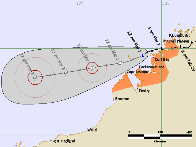
A Cyclone WARNING is now current for coastal areas from Kuri Bay to Broome
At 3:00 pm WDT a Tropical Low was estimated to be
100 kilometres west of Kuri Bay and
310 kilometres north northeast of Broome and
moving west southwest at 13 kilometres per hour
The tropical low may develop into a Tropical Cyclone later today or Sunday
morning as it continues moving on a general west or west southwesterly track.
GALES with gusts to 100 kilometres per hour may develop in coastal areas between
Kuri Bay and Broome for a period tonight or during Sunday morning. The risk of
gales should then decrease from the northeast as the system moves away from the
coast.
Details of Tropical Low at 3:00 pm WDT:
.Centre located near...... 15.5 degrees South 123.6 degrees East
.Location accuracy........ within 55 kilometres
.Recent movement.......... towards the west southwest at 13 kilometres per hour
.Wind gusts near centre... 85 kilometres per hour
.Severity category........ below cyclone intensity
.Central pressure......... 994 hectoPascals
FESA-State Emergency Service advises that there are no community alerts at
present. Communities between Kuri Bay and Broome should listen to the next
advice.
The next advice will be issued by 7:00 pm WDT Saturday 01 March.
Cyclone advices and State Emergency Service Community Alerts are available by
dialling 1300 659 210
A map showing the track of the cyclone is available at:
http://www.bom.gov.au/weather/cyclone