

ATL: Tropical Depression Fay
Moderator: S2k Moderators

Re: ATL: Invest 92L in Western Atlantic
Heat potential and sea surface temps for potential south of Cuba & GOM track.


0 likes
-
Matt-hurricanewatcher
Re: ATL: Invest 92L in Western Atlantic
The 10,000 foot mountains of Hati/DR await this system. It will likely take about 18 hours to cross it. The powerful mid level cirulation might help it a little, but we will see.
0 likes
-
cycloneye

- Admin

- Posts: 149357
- Age: 69
- Joined: Thu Oct 10, 2002 10:54 am
- Location: San Juan, Puerto Rico
Re: ATL: Invest 92L in Western Atlantic
GreenSky wrote:cycloneye wrote:Tony,I think that with this track 92L is taking,the threat to the Penninsula lessens.What do you think?
what peninsula are you referring to, Luis?
Florida
0 likes
-
DESTRUCTION5

- Category 5

- Posts: 4430
- Age: 44
- Joined: Wed Sep 03, 2003 11:25 am
- Location: Stuart, FL
Re: ATL: Invest 92L in Western Atlantic
cycloneye wrote:GreenSky wrote:cycloneye wrote:Tony,I think that with this track 92L is taking,the threat to the Penninsula lessens.What do you think?
what peninsula are you referring to, Luis?
Florida
Id say in intensity yes but track no...but thats just my opinion..
0 likes
-
weatherguru18
Re: ATL: Invest 92L in Western Atlantic
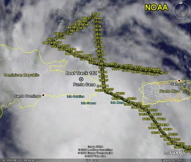
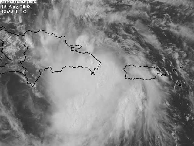
Certainly looks south of DR to me. If you look at the Sat pic closely, it appears to have taken a wsw jog...
0 likes
-
Stormcenter
- S2K Supporter

- Posts: 6689
- Joined: Wed Sep 03, 2003 11:27 am
- Location: Houston, TX
Re: ATL: Invest 92L in Western Atlantic
I'm sorry if I offend anyone but this is becoming comical.
We have some on this board who think the "center" is north of DR and others
who think it's south and then there are the ones who can't
find any center or don't care because it still "looks" so good it should be a TS already.
All of that in itself should tell you a lot about the current state of 92L.
There is a ton of smoke but NO fire.
Last edited by Stormcenter on Fri Aug 15, 2008 2:06 pm, edited 1 time in total.
0 likes
-
hurricanefloyd5

- Category 5
- Posts: 1659
- Age: 45
- Joined: Sun May 02, 2004 10:53 am
- Location: Spartanburg
- Contact:
Re: ATL: Invest 92L in Western Atlantic
are you saying luis that florida is less of a threat from this system???????????
0 likes
-
GreenSky
- Tropical Storm

- Posts: 109
- Joined: Mon Aug 11, 2008 8:34 pm
- Location: Land of Alex Jones!-Austin,TX
Re: ATL: Invest 92L in Western Atlantic
cycloneye wrote:GreenSky wrote:cycloneye wrote:Tony,I think that with this track 92L is taking,the threat to the Penninsula lessens.What do you think?
what peninsula are you referring to, Luis?
Florida
Well the GFS and GFDL are hinting at a Charley like scenario, right?
0 likes
-
Air Force Met
- Military Met

- Posts: 4372
- Age: 57
- Joined: Tue Jul 08, 2003 9:30 am
- Location: Roan Mountain, TN
Re:
gatorcane wrote:alright folks please take a minute to look at this vis loop. This should clear up any confusion. I clearly see an "LLC" moving along the northern coast of Dr...possibly on the northern part of the island. All of that deep convection to the south is feeding into it. Check out 18N 68W.....
There is no LLC south of the island.
http://metofis.rsmas.miami.edu/~dortt/s ... 1_loop.gif
Maybe you clearly see that...but i sure don't. I see it over the eastern end of the DR...near 18.5/68.5...
and BTW...try this vis loop...its one of the best on the commercial side...
http://wwwghcc.msfc.nasa.gov/cgi-bin/ge ... map=latlon
0 likes
Re: ATL: Invest 92L in Western Atlantic
With the system not quite a system yet, I believe that a center will form where it's most favorable. IOW with the mountains there and the system not formed, I think it's a good prospect that it will simply form an LLC either north or south of it. Of course if that gets away from the (edit: I mean MLC, not LLC) LLC it'll take a while to set up again. But in this specific case I don't think the mountains are going to make a cyclone not happen.
Matt-hurricanewatcher wrote:The 10,000 foot mountains of Hati/DR await this system. It will likely take about 18 hours to cross it. The powerful mid level cirulation might help it a little, but we will see.
Last edited by physicx07 on Fri Aug 15, 2008 2:07 pm, edited 1 time in total.
0 likes
-
Stormcenter
- S2K Supporter
- Posts: 6689
- Joined: Wed Sep 03, 2003 11:27 am
- Location: Houston, TX
Re: ATL: Invest 92L in Western Atlantic
jlauderdal wrote:AtlanticWind wrote:canejacket wrote:I'm not a pro by a long shot, but it looks to me according to the Punta radar that the storm is still moving WNW rather than WSW.
Looking at a visable loop I have to agree , looks to be on the north coast of the DR
they have a plane out there folks, if there is a center they will find it, don't worry about trying to read sats, that is an art more than anything, trust me
There is no "art" to it. In "Well developed" systems you don't have to rely on the recon to tell where the center is if there is one. It's pretty obvious to naked eye when looking at any satellite loop.
0 likes
-
cheezyWXguy

- Category 5
- Posts: 6282
- Joined: Mon Feb 13, 2006 12:29 am
- Location: Dallas, TX
Re: ATL: Invest 92L in Western Atlantic
weatherguru18 wrote:Certainly looks south of DR to me. If you look at the Sat pic closely, it appears to have taken a wsw jog...
Its not and I have absolutely no idea what youre talking about.
0 likes
Re: ATL: Invest 92L in Western Atlantic
I think it's kind of funny too. Particularly the news reporters getting so uppity when it's 4 days away from FL anyway.
Stormcenter wrote:I'm sorry if I offend anyone but this is becoming comical.
We some who think the "center" is north of DR and others
who think it's south and then there are the ones who can't
find any center or don't care because it still "looks" so good it should be a TS already.
All of that in itself should tell you a lot about the current state of 92L.
There is a ton of smoke but NO fire.
0 likes

Re: ATL Invest 92L Pet and Wildlife Reactions

Here's a pic of this lost bird. If I see her again, I'll ask her where she came from so we can know where "Fay" may be heading!
0 likes
-
seaswing

- S2K Supporter
- Posts: 561
- Joined: Sun Aug 31, 2003 11:56 am
- Location: High Springs, FL/just NW of Gainesville
Re: ATL: Invest 92L in Western Atlantic
physicx07 wrote:I think it's kind of funny too. Particularly the news reporters getting so uppity when it's 4 days away from FL anyway.Stormcenter wrote:I'm sorry if I offend anyone but this is becoming comical.
We some who think the "center" is north of DR and others
who think it's south and then there are the ones who can't
find any center or don't care because it still "looks" so good it should be a TS already.
All of that in itself should tell you a lot about the current state of 92L.
There is a ton of smoke but NO fire.
Well, as far as preparation goes... 4 days away is not really that far away!
0 likes
-
Air Force Met
- Military Met
- Posts: 4372
- Age: 57
- Joined: Tue Jul 08, 2003 9:30 am
- Location: Roan Mountain, TN
Re: ATL: Invest 92L in Western Atlantic
fci wrote: AFM:
So if 92L tracks south of of DR what does that say to an expected future track?
I think the Fl panhandle or possibly as far west as AL could have issues. ...but somewhere along the west coast of FL would be my guess...
0 likes
-
weatherguru18
Re: ATL: Invest 92L in Western Atlantic
cheezyWXguy wrote:weatherguru18 wrote:Certainly looks south of DR to me. If you look at the Sat pic closely, it appears to have taken a wsw jog...
Its not and I have absolutely no idea what youre talking about.
http://www.goes.noaa.gov/HURRLOOPS/huirloop.html
I think your the one that needs to double check. Any LLC, like Derek said, is due east of the DR...and IMO moving slightly south of due west.
0 likes
Who is online
Users browsing this forum: No registered users and 20 guests