ATL: Tropical Depression Dolly
Moderator: S2k Moderators
-
cperez1549

- Tropical Low

- Posts: 12
- Age: 39
- Joined: Sun Jul 20, 2008 9:42 am
- Contact:
Re: ATL: TS Dolly in Western Caribbean
They are already posting Possible Tropical Condition on our 7 day outlook for the Brownsville area check the link out. http://forecast.weather.gov/MapClick.php?site=bro&map.x=306&map.y=242
0 likes
-
HURAKAN

- Professional-Met

- Posts: 46084
- Age: 39
- Joined: Thu May 20, 2004 4:34 pm
- Location: Key West, FL
- Contact:
If you want to see the center, watch this loop and set the Animation Speed high. You can't miss it. You don't need RECON, in this case, to tell you where the LLC is.
Loop: http://rammb.cira.colostate.edu/product ... 201345.GIF
Loop: http://rammb.cira.colostate.edu/product ... 201345.GIF
0 likes

Re: ATL: TS Dolly in Western Caribbean
There is some uncertainty as to final landfall after Dolly gets into the GOM due to the forecast of a weakening ridge.I tend to doubt south of Brownsville is the spot.Maybe between Brownsville and Corpus Christi
0 likes
-
ColdFusion

- S2K Supporter

- Posts: 452
- Joined: Wed Feb 13, 2008 3:46 pm
- Location: Addison, TX
Re: ATL: TS Dolly in Western Caribbean
cperez1549 wrote:They are already posting Possible Tropical Condition on our 7 day outlook for the Brownsville area check the link out. http://forecast.weather.gov/MapClick.php?site=bro&map.x=306&map.y=242
I think I hear Jim Cantore booking a room as we speak....
0 likes
-
Ed Mahmoud
Re: ATL: TS Dolly in Western Caribbean
Staring intently at visible loop floater, there is too much cirrus to see enough of the low cloud motion to fix a low level center with any accuracy. So, assuming the navigational equipment on a modern Air Force transport specially modified for tropical cyclone investigation missions is working, I'd assume the recon center is correct.
The good news/bad news, is that about this time Tuesday, or a touch later, I suspect arguing over the center based on satellite will be moot, as an eye feature on a minimal hurricane will start becoming apparent. Assuming we don't have a sloppy Bertha partial double eyewall.
The good news/bad news, is that about this time Tuesday, or a touch later, I suspect arguing over the center based on satellite will be moot, as an eye feature on a minimal hurricane will start becoming apparent. Assuming we don't have a sloppy Bertha partial double eyewall.
0 likes
-
Ad Novoxium
- Category 1

- Posts: 348
- Age: 35
- Joined: Sat May 03, 2008 2:12 am
Re: ATL: TS Dolly in Western Caribbean
RL3AO wrote:
Confusion with the center? Didn't an older tropical storm look kind of like this too?

(Earl of 04)
0 likes
-
Ed Mahmoud
Re: ATL: TS Dolly in Western Caribbean
ColdFusion wrote:cperez1549 wrote:They are already posting Possible Tropical Condition on our 7 day outlook for the Brownsville area check the link out. http://forecast.weather.gov/MapClick.php?site=bro&map.x=306&map.y=242
I think I hear Jim Cantore booking a room as we speak....
I hope it is Stephanie Abrams. Easier on the eyes.
0 likes
-
cheezyWXguy

- Category 5

- Posts: 6282
- Joined: Mon Feb 13, 2006 12:29 am
- Location: Dallas, TX
Re: ATL: TS Dolly in Western Caribbean
Lol I think I know what it is...The llc isnt going under the mlc. A new mlc is forming over the llc. Based on the latest Ramsdis floater image, assuming the center is where that extremely deep new burst of convection is, it looks like all the storms are beginning to rotate around this point.
0 likes

Re: ATL: TS Dolly in Western Caribbean
>>A lot of folks here are mistaking what is simply a relatively cloud-free area for some sort of center. I can't say this any more clearer than this: There has been a plane in there all day taking continuous in situ pressure and wind observations. You cannot get a better fix from remotely sensed data than you can a recon flight - no way, no how.
Thanks AJ. Another thing that posters should remember is that in relatively weak systems (static or strengthening), there are often several areas of turning within a system. Sometimes there are unstacked centers of circulation, sometimes there are multiple vorticies, sometimes the overall system just turns around an axis/central point that isn't the true low-level center. Those are just some of the things that happen with weaker or developing systems. Recon is always the final say unless there are multiple centers swriling.
Steve
0 likes

-
cperez1549
- Tropical Low
- Posts: 12
- Age: 39
- Joined: Sun Jul 20, 2008 9:42 am
- Contact:
Re: ATL: TS Dolly in Western Caribbean
Ed Mahmoud wrote:ColdFusion wrote:cperez1549 wrote:They are already posting Possible Tropical Condition on our 7 day outlook for the Brownsville area check the link out. http://forecast.weather.gov/MapClick.php?site=bro&map.x=306&map.y=242
I think I hear Jim Cantore booking a room as we speak....
I hope it is Stephanie Abrams. Easier on the eyes.
It has been a while since we have seen a storm here in the South Texas area I belive 2005 Emily missed us just to the south.
0 likes

A new burst of convection over the center.
http://rammb.cira.colostate.edu/products/tc_realtime/1kmsrvis_loop.asp?storm_identifier=AL042008&starting_image=2008AL04_1KMSRVIS_200807201345.GIF
http://rammb.cira.colostate.edu/products/tc_realtime/1kmsrvis_loop.asp?storm_identifier=AL042008&starting_image=2008AL04_1KMSRVIS_200807201345.GIF
0 likes
Re:
KatDaddy wrote:Its the MLC and LLC rotating around each other.
you know, that what it looks like on the ramdis visible loop to me also
it's like
the MLC said "meet me up here, and then we roll"
and the llC said "who you think you talking to, i call the shots, i'll meet you half way"
or something like that
Last edited by cpdaman on Sun Jul 20, 2008 3:49 pm, edited 1 time in total.
0 likes

-
AJC3

- Admin

- Posts: 4153
- Age: 62
- Joined: Tue Aug 31, 2004 7:04 pm
- Location: Ballston Spa, New York
- Contact:
Re:
jasons wrote:Looking at the visibles: to me it looks like the LLC I've been watching all day (SW of most of the convection) has fallen apart in the last few frames. I think the center will relocate further NE overnight (if it is not already happening).
I think that's very possible, considering it's only a formative 40kt TC. It'll be nice to get a few fixes from the next RECON flight. A good MI pass between now and then would be nice to have.
0 likes
-
cheezyWXguy
- Category 5
- Posts: 6282
- Joined: Mon Feb 13, 2006 12:29 am
- Location: Dallas, TX
Re: Re:
AJC3 wrote:jasons wrote:Looking at the visibles: to me it looks like the LLC I've been watching all day (SW of most of the convection) has fallen apart in the last few frames. I think the center will relocate further NE overnight (if it is not already happening).
I think that's very possible, considering it's only a formative 40kt TC. It'll be nice to get a few fixes from the next RECON flight. A good MI pass between now and then would be nice to have.
I doubt its reforming right now...take a look. Very deep convection has formed again over the llc, and convection is building into the west half of the system. If strengthening has happened yet in this storm, its bound to happen within the next few hours.
0 likes
-
Aric Dunn
- Category 5
- Posts: 21238
- Age: 43
- Joined: Sun Sep 19, 2004 9:58 pm
- Location: Ready for the Chase.
- Contact:
Re: Re:
AJC3 wrote:jasons wrote:Looking at the visibles: to me it looks like the LLC I've been watching all day (SW of most of the convection) has fallen apart in the last few frames. I think the center will relocate further NE overnight (if it is not already happening).
I think that's very possible, considering it's only a formative 40kt TC. It'll be nice to get a few fixes from the next RECON flight. A good MI pass between now and then would be nice to have.
yeah i agree .. just got done doing my afternoon sat analysis and agree the center has either been pulled north more nearer the deep convection from earlier and or has reformed.
0 likes
-
ColdFusion
- S2K Supporter
- Posts: 452
- Joined: Wed Feb 13, 2008 3:46 pm
- Location: Addison, TX
Re: ATL: TS Dolly in Western Caribbean
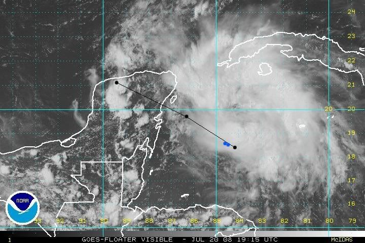
AT 500 PM EDT...2100Z...THE CENTER OF TROPICAL STORM DOLLY WAS
LOCATED NEAR LATITUDE 18.9 NORTH...LONGITUDE 85.0 WEST OR ABOUT 220
MILES...350 KM...EAST OF CHETUMAL MEXICO AND ABOUT 165 MILES...265
KM...SOUTHEAST OF COZUMEL MEXICO.
LOCATED NEAR LATITUDE 18.9 NORTH...LONGITUDE 85.0 WEST OR ABOUT 220
MILES...350 KM...EAST OF CHETUMAL MEXICO AND ABOUT 165 MILES...265
KM...SOUTHEAST OF COZUMEL MEXICO.
0 likes
-
Cape Verde

- Category 2

- Posts: 564
- Age: 70
- Joined: Tue Aug 31, 2004 5:53 pm
- Location: Houston area
Re: ATL: TS Dolly in Western Caribbean
I'm not going to argue with the recon, but I will say that looks can be deceiving. The MLC is much easier to discern from satellite than the LLC, and instinctively you don't think the prominent burst of convection will be directly over the LLC.
That's me, a rookie, talking. My eyes say the storm is north of where it is, and I still say half the storm is missing. I'm issuing an Amber Alert.
That's me, a rookie, talking. My eyes say the storm is north of where it is, and I still say half the storm is missing. I'm issuing an Amber Alert.
Last edited by Cape Verde on Sun Jul 20, 2008 3:56 pm, edited 1 time in total.
0 likes
Who is online
Users browsing this forum: No registered users and 18 guests