
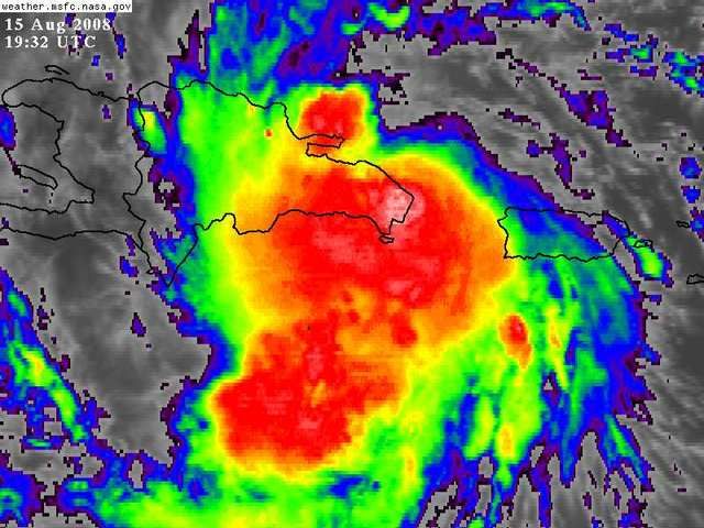
If the cloud tops are warming it means there are less deep reds in the IR loop which means its probably on a weakening trend (maybe)
ATL: Tropical Depression Fay
Moderator: S2k Moderators

Re: ATL: Invest 92L in Western Atlantic
I don't believe so. When 2 low pressure systems get close to each other, one tends to dominate the other. The low pressure point is like a stable solution. If you try to split it, it will try to return to its more stable state. OK, it's just a guess, but sounds good, no? 
haml8 wrote:HURAKAN wrote:haml8 wrote:Is there EVER a possibility that the Low could split and form two LLC's? One North and one South?
That would be fun but unlikely.
I figured that it was unlikley, but is it scientifically possible?
0 likes
-
ConvergenceZone
.gif)
- Category 5

- Posts: 5241
- Joined: Fri Jul 29, 2005 1:40 am
- Location: Northern California
Re:
gatorcane wrote::uarrow:
If the cloud tops are warming it means there are less deep reds in the IR loop which means its probably on a weakening trend (maybe)
of course the weakening trend is just temporary, but you may be right...
0 likes
-
Stormcenter
- S2K Supporter

- Posts: 6689
- Joined: Wed Sep 03, 2003 11:27 am
- Location: Houston, TX
Re: Re:
canegrl04 wrote:93superstorm wrote:Wow very confusing in here with all these opinions, but it does look more south or convection is developin south to make it look like it:
How ironic that its starting to get its act together now as it interacts with land.If it can survive the islands still relatively intact,it could become a hurricane yet.The GOM has plenty of juice

The "juice (warm water) " is only one ingredient in the receipt for development in the tropics. The upper level winds also play a big part.
0 likes
-
SouthFloridawx

- S2K Supporter
- Posts: 8346
- Age: 47
- Joined: Tue Jul 26, 2005 1:16 am
- Location: Sarasota, FL
- Contact:
Re: ATL: Invest 92L in Western Atlantic
192900 1800N 06908W 9548 00487 0095 +221 +170 274011 011 038 005 00
192930 1800N 06909W 9546 00489 0096 +219 +170 277012 012 037 006 00
192930 1800N 06909W 9546 00489 0096 +219 +170 277012 012 037 006 00
0 likes
-
Cat5x
Re:
gatorcane wrote::uarrow:
If the cloud tops are warming it means there are less deep reds in the IR loop which means its probably on a weakening trend (maybe)
but that is not happening right now, http://www.ssd.noaa.gov/goes/flt/t1/loop-avn.html just as many as there has been for the last 6 hours.
0 likes
-
Stormcenter
- S2K Supporter
- Posts: 6689
- Joined: Wed Sep 03, 2003 11:27 am
- Location: Houston, TX
Re: Re:
ConvergenceZone wrote:gatorcane wrote::uarrow:
If the cloud tops are warming it means there are less deep reds in the IR loop which means its probably on a weakening trend (maybe)
of course the weakening trend is just temporary, but you may be right...
Not if the center (if there finally is one) stays over the islands for a good period of time.
0 likes


-
canejacket
- Tropical Low

- Posts: 15
- Joined: Wed Jul 27, 2005 8:15 pm
Re:
gatorcane wrote::uarrow:
If the cloud tops are warming it means there are less deep reds in the IR loop which means its probably on a weakening trend (maybe)
Well, shows how much I know. I assumed that would point towards strengthening. Thanks for the explanation.
0 likes
-
Air Force Met
- Military Met

- Posts: 4372
- Age: 57
- Joined: Tue Jul 08, 2003 9:30 am
- Location: Roan Mountain, TN
Re: ATL: Invest 92L in Western Atlantic
storms in NC wrote: A little Bold statment for a pro. From a non pro is par for the corse. That would really up set a few people. Would make some who really don't have the money go out and buy things when they could use it on their bills. Some people don't think like that. I think till NHC knows where the center is I wouldn't say where it could go.
Sorry if I steped out of place.
For you all in the Islands I hope you stay safe.
Someone asked a question in regards to what would happen IF it tracked south of the DR...I answered ...to the best of my ability...what would happen to the future track (IMO) if this did go south of the DR.
If you would rather us not answer those types of questions...then perhaps you are on the wrong forum.
And if someone does go out and buy things this far out...on a system that isn't even ID'd yet...based on a post in a forum...then a fool and their money is soon parted. They should know better and not be so chicken little. I certainly won't feel guilty over someone's bad decision.
Besides...if you live in a hurricane prone area...you should already have stuff bought ANYWAY. We have our hurricane kit. It sits in our closet...and we eat all the food stuffs at the end of the season
0 likes
-
DESTRUCTION5

- Category 5
- Posts: 4430
- Age: 44
- Joined: Wed Sep 03, 2003 11:25 am
- Location: Stuart, FL
Re: ATL: Invest 92L in Western Atlantic
DESTRUCTION5 wrote:Derek Ortt wrote:for the first time, this MAY be a cyclone
LOL..ANd may be the shortest lived!
One thing I have learned from watching the tropics, is that the really persistent systems are the ones you really have to watch out for.
What is it that causes one system to seem to have a distinct "personality" is surely just a matter of physics, but, it doesn't seem to explain why some systems survive conditions that have shredded more robust systems.
Of course, we may not evev know what all of those conditions are, at this point in the development of meteorology.
I hate bad science, but i can't help thinking this sucker HAS to be taken seriously.
Zip
0 likes
-
Blown Away

- S2K Supporter
- Posts: 10253
- Joined: Wed May 26, 2004 6:17 am
Re: ATL: Invest 92L in Western Atlantic
[img][URL=http://imageshack.us]
TAFB Link: http://www.nhc.noaa.gov/tafb_latest/atl ... BW_sm3.gif
92L seems to be moving in the general direction of the 24 hour TAFB point. 92L should be off the coast in <24 hours if it makes it to that point.
TAFB Link: http://www.nhc.noaa.gov/tafb_latest/atl ... BW_sm3.gif
92L seems to be moving in the general direction of the 24 hour TAFB point. 92L should be off the coast in <24 hours if it makes it to that point.
0 likes
-
OuterBanker
- S2K Supporter
- Posts: 1761
- Joined: Wed Feb 26, 2003 10:53 am
- Location: Nags Head, NC
- Contact:
-
sfwx

- Category 1

- Posts: 371
- Age: 60
- Joined: Thu Sep 04, 2003 1:53 pm
- Location: Rural St. Lucie County, Fl
Re: ATL: Invest 92L in Western Atlantic
AREA FORECAST DISCUSSION
NATIONAL WEATHER SERVICE MELBOURNE FL
255 PM EDT FRI AUG 15 2008
.DISCUSSION...
SAT NIGHT-SUNDAY...UPPER TROUGH SLOWLY LIFTING NORTHEAST SAT-SUN
ALLOWS ATLANTIC UPPER RIDGE TO START BUILDING WEST ACROSS SOUTH
FLORIDA. LIGHT ENVIRONMENTAL FLOW AND SUITABLE MOISTURE WILL ALLOW
FOR SCATTERED AFTERNOON SHOWERS/STORMS.
DISTURBANCE NEAR DOMINICAN REPUBLIC CONTINUES ORGANIZATION AND NOAA
AIRCRAFT RECENTLY FOUND 50 KT FLIGHT LEVEL WINDS. SYSTEM EXPECTED TO
DIRECTLY INFLUENCE OUR FORECAST AND THE MEDIUM RANGE REMAINS HIGHLY
UNCERTAIN DUE TO CONTINUED MODEL DIVERGENCE. CURRENT HPC/NHC TRACK
IN THE MEDIUM RANGE INDICATES A TRACK JUST EAST OF THE STATE AND
THIS IS HIGHLY SUBJECT TO REVISIONS LATER TODAY AND DURING THE
WEEKEND.
PLEASE STAY TUNED TO NOAA WEATHER RADIO...AS WELL AS INFORMATION
FROM LOCAL GOVERNMENT OFFICIALS AND MEDIA OUTLETS. YOU CAN ALSO
MONITOR THE LATEST STATEMENTS...AS WELL AS POSSIBLE WATCHES AND
WARNINGS...FROM THE NATIONAL WEATHER SERVICE OFFICE IN MELBOURNE ON
THE WEB AT WEATHER.GOV/MELBOURNE.
SHORT TERM/AVIATION...CRISTALDI
LONG TERM....PENDERGRAST
0 likes
Who is online
Users browsing this forum: Google [Bot] and 34 guests