ATL: Tropical Depression Fay
Moderator: S2k Moderators
-
ConvergenceZone
.gif)
- Category 5

- Posts: 5241
- Joined: Fri Jul 29, 2005 1:40 am
- Location: Northern California
Re: ATL: Tropical Storm Fay
The good news is that it probably won't be a wind event for florida or the islands, just a rain event...let's hope that the flooding isn't too severe and not too many lives are lost on the islands, but I know 1 life lost is too many...but at least it will be rain and not rain/wind
0 likes
-
vbhoutex

- Storm2k Executive

- Posts: 29146
- Age: 74
- Joined: Wed Oct 09, 2002 11:31 pm
- Location: Cypress, TX
- Contact:
Re:
gatorcane wrote:I see Fay trying to lift more north now......center now skirting the ENE tip of DR.
Here's a quick loading loop:
http://metofis.rsmas.miami.edu/~dortt/s ... 1_loop.gif
I have to disagree. The center is still along the SE coast and in fact I see storms blosssoming near and to the SW of it. I can see how one might think what is along the N coast is the center, but NHC has it much further S.
http://www.ghcc.msfc.nasa.gov/cgi-bin/post-goes
0 likes
-
txwatcher91
- Category 5
- Posts: 1498
- Joined: Tue Aug 02, 2005 2:29 pm
Re:
Derek Ortt wrote:I'm seeing a straight west motion
You sure, DR and PR radar both show a north of west motion, maybe not quite WNW but pretty close.
0 likes


Pinpoint the center
Would someone be kind enough to post a picture of the satelite and pinpoint where the LLC is currently located?
0 likes
-
Brent
- S2K Supporter

- Posts: 38736
- Age: 37
- Joined: Sun May 16, 2004 10:30 pm
- Location: Tulsa Oklahoma
- Contact:
Re: Re:
vbhoutex wrote:gatorcane wrote:I see Fay trying to lift more north now......center now skirting the ENE tip of DR.
Here's a quick loading loop:
http://metofis.rsmas.miami.edu/~dortt/s ... 1_loop.gif
I have to disagree. The center is still along the SE coast and in fact I see storms blosssoming near and to the SW of it. I can see how one might think what is along the N coast is the center, but NHC has it much further S.
http://www.ghcc.msfc.nasa.gov/cgi-bin/post-goes
I also am leaning towards that as well. Hard to ignore all that convection. I don't see this making a beeline for the northern coast.
0 likes


looking at vis sat, the east/west oriented boundry/front/whatever across central fla into the GOM shows all weather moving east along and near it. If this is a TS or weak HURR when it interacts with it, can it really punch right strait thru without any change in corse, or wouldnt a weaker system at least feel the effects of that west to east flow and still curve east? Could this be why some models were moving it east of FLA for the last few days? Just wondering......
0 likes


Re: ATL: Tropical Storm Fay
I'm scared to see the news reports out of the DR/Haiti the next few days.
0 likes
-
tolakram
- Admin
- Posts: 20183
- Age: 62
- Joined: Sun Aug 27, 2006 8:23 pm
- Location: Florence, KY (name is Mark)
Re: ATL: Tropical Storm Fay
Fay hitting western Florida would be a first.
Not that we have that much data to work with so something new never surprises me.
0 likes
-
hurricanefloyd5
- Category 5
- Posts: 1659
- Age: 45
- Joined: Sun May 02, 2004 10:53 am
- Location: Spartanburg
- Contact:
Re: ATL: Tropical Storm Fay
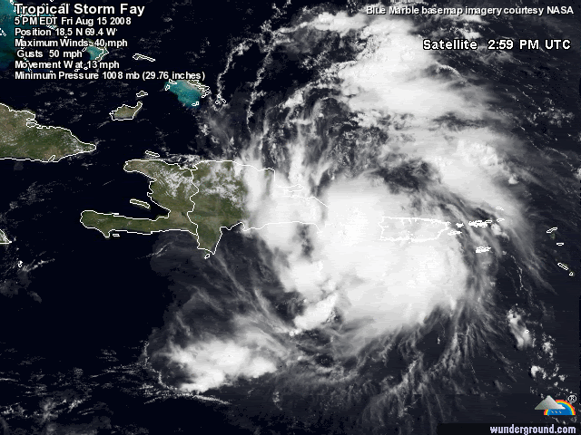
reports from NOAA and Air Force Reserve hurricane hunter aircraft
indicate that the circulation associated with the low pressure area
in the Mona Passage became better defined...with 1500 ft
flight-level winds of 49 kt to the northeast of the center. The
aircraft also found enough westerly winds south of the center to
justify calling the system a tropical cyclone...although these
westerlies only extend about 45 N mi south of the center. Based on
this...the low was upgraded to Tropical Storm Fay...the sixth of
the Atlantic season.
The initial motion is 275/12. Fay is on the south side of a
low/mid-level ridge...with the large-scale models forecasting a
weakness to develop in the ridge over the eastern Gulf of Mexico
or Florida during the next 48-96 hr. While all the track guidance
agrees that this weakness will cause Fay to turn north-
northwestward to northward by the end of the forecast period...this
is a considerable spread in the guidance on just where Fay will
track. The NAM calls for Fay to pass east of the Florida
Peninsula...while the HWRF calls for landfall in southeastern
Florida. The GFDL and NOGAPS forecast a more westward track toward
the northern Gulf Coast...while the GFS...ECMWF...and the model
consensus forecasts Fay to track near or over the West Coast of
Florida. Complicating matters is the possibility of land
interaction causing erratic motion and reformation of the center.
The forecast track will follow the model consensus and call for Fay
to cross Hispaniola and the eastern portion of Cuba...then pass
near or over the Florida Keys and the West Coast of Florida.
The large-scale models forecast Fay to be in a light vertical wind
shear environment for the next 72-96 hr. Thus...the intensity will
be controlled by land interaction and internal structure. The
forecast track calls for Fay to cross large portions of Hispaniola
and Cuba...which should limit intensification. Significant
strengthening is expected when the center emerges from the north
coast of Cuba...although it is uncertain how well organized the
storm will be at that time. The intensity forecast will call for a
peak intensity of 60 kt...and there is about a 30 percent chance
that Fay could become a hurricane at that time. It should be noted
that any deviations from the forecast track that allow Fay more
time over water would result in a storm stronger than currently
forecast.
Forecast positions and Max winds
initial 15/2100z 18.5n 69.4w 35 kt...inland
12hr VT 16/0600z 18.9n 71.3w 35 kt...inland
24hr VT 16/1800z 19.4n 74.1w 35 kt...over water
36hr VT 17/0600z 19.9n 76.5w 40 kt
48hr VT 17/1800z 20.7n 78.2w 40 kt
72hr VT 18/1800z 23.5n 81.0w 40 kt...over coast of Florida
96hr VT 19/1800z 26.5n 82.0w 60 kt...inland over Florida
120hr VT 20/1800z 30.0n 83.0w 40 kt...inland
$$
forecaster Beven
0 likes
-
Extremeweatherguy

- Category 5
- Posts: 11095
- Joined: Mon Oct 10, 2005 8:13 pm
- Location: Florida
A local meteorologist just showed a model (I assume an in-house one) that looks very close to Derek Ortt's forecast. It shows this system located just west of Tampa by Tuesday afternoon, possibly as a hurricane. The meteorologist then went on to say, "Tuesday is probably going to be a nasty day for the entire state". Great.. 
0 likes


-
hurricanefloyd5
- Category 5
- Posts: 1659
- Age: 45
- Joined: Sun May 02, 2004 10:53 am
- Location: Spartanburg
- Contact:
Re:
Extremeweatherguy wrote:A local meteorologist just showed a model (I assume an in-house one) that looks very close to Derek Ortt's forecast. It shows this system located just west of Tampa by Tuesday afternoon, possibly as a hurricane. The meteorologist then went on to say, "Tuesday is probably going to be a nasty day for the entire state". Great..
Was that tom terry that said that?????????
0 likes
-
Air Force Met
- Military Met

- Posts: 4372
- Age: 57
- Joined: Tue Jul 08, 2003 9:30 am
- Location: Roan Mountain, TN
Re:
Derek Ortt wrote:I'm seeing a straight west motion
Me too. Maybe a tad north of west...but pretty much west.
0 likes


-
lonelymike
- S2K Supporter
- Posts: 634
- Joined: Sat Jul 26, 2008 10:12 am
- Location: walton county fla
Re: ATL: Tropical Storm Fay
What the NHC forecast track error for like 5 days out? I've seen like 24 is 50 miles or something like that. Can anyone do or post it for like 24 48 72 96 and 120 out? Thanks
0 likes
Who is online
Users browsing this forum: No registered users and 9 guests