#4406 Postby Matt-hurricanewatcher » Fri Aug 15, 2008 4:39 pm
Personal Forecast Disclaimer:
The posts in this forum are NOT official forecast and should not be used as such. They are just the opinion of the poster and may or may not be backed by sound meteorological data. They are NOT endorsed by any professional institution or storm2k.org. For official information, please refer to the NHC and NWS products.
Tropical storm Fay
Forecast one
2:30pm pst/5:30pm est
8-15-2008
Winds 45 knots
Pressure 1008 millibars
Movement westward at 12 knots
Location 18.5/68.8
Strong distrabance moving over DR has become a tropical storm...
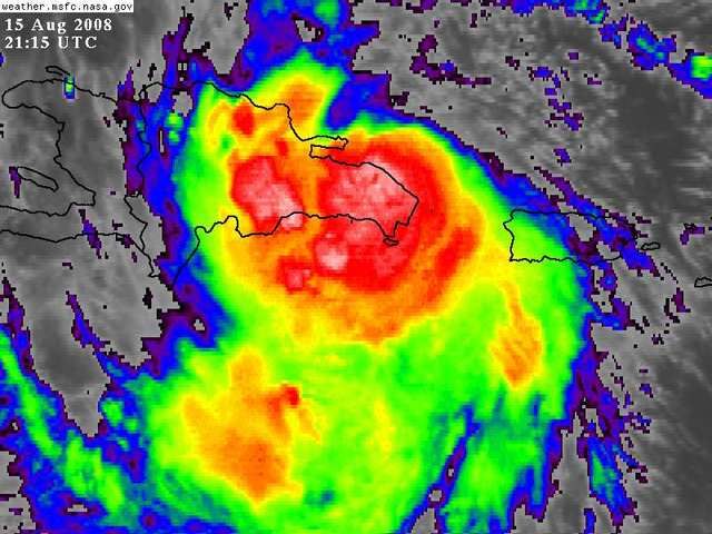
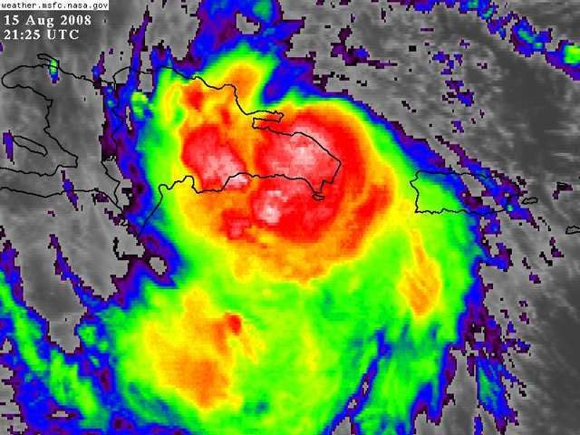
Recon has found westly winds south of southern DR this afternoon...In which case confirms that this system now has a closed LLC. The cyclone has formed a nice blow up near where the LLC is. The LLC is inland over the DR around 18.5/68.8. The higher mountains of DR and Hati await this system in the inner core should become very broad as it moves over it, so overall tropical storm force winds will increase in size. The system innercore is likely to only have winds by 24 hours of 25-30 knots. But one of the reasons that may keep this a tropical storm is the fact the banding over the southern side; could still have tropical storm force winds. This system is moving fast enough to not produce another Jeanne like event, but it could be quite bad for the DR/Hati.
The distrabance that has been tracked overnight last night north of PR has become better organized throughout today. Earlier today you could clearly see the southern banding forming and wraping into the broader LLC future to its north. This feature I believe made landfall as a tropical storm, reaspm 1# westly winds where reported on the southern coast of the DR as early as 2-3 hours ago. Also 2# the banding and inflow was formed nicely around this area, with overall low clouds showing it to be closed.
Cimss shows that a strong Anticyclone has formed just north of the LLC. So the environment is very favorable for strengthing, but as it is going over DR/Hati, we do not expect any strengthing from the cyclone. In fact it is likely to weaken to a depression with in the next 24 hours. If it moves south of Cuba it kind again find its self in a favorable environment for strengthing, in which case we feel is becoming a little more likely. We will bring to to 75 knots by 96-120 hours. But this could be low if the environment is favorable.
The Gfdl 12z keeps it as a weak system throughout the next 48 hours. It takes it south of Cuba. Then restrengthens it around 72 hours to a hurricane as it is making landfall in western Cuba. So around 84-96 hours it turns north as a trough picks it up. Since it is south of what the models have forecasted, in this trough appears to be coming around the same time frame, it has model support. The LCEM is the eastern model and the GFDL is the western driving the cyclone to near 85 west. Nhc is forecasting landfall near the clip5 model down the middle, but we feel the cmc,UKmet,Gfdl is more likely. In which is where we we forecast it to track.
Forecast
0 45 knots 18.5/68.8
6 35 knots 18.6/69.5
12 35 knots 18.6/70.5
24 35 knots 18.8/73.2
36 45 knots 19.1/75.4 South of Cuba
48 55 knots 19.5/77.5
72 60 knots 20.5/82.4
96 70 knots 24.2/84.4 Gulf
120 75 knots 27.4/85.2
0 likes


