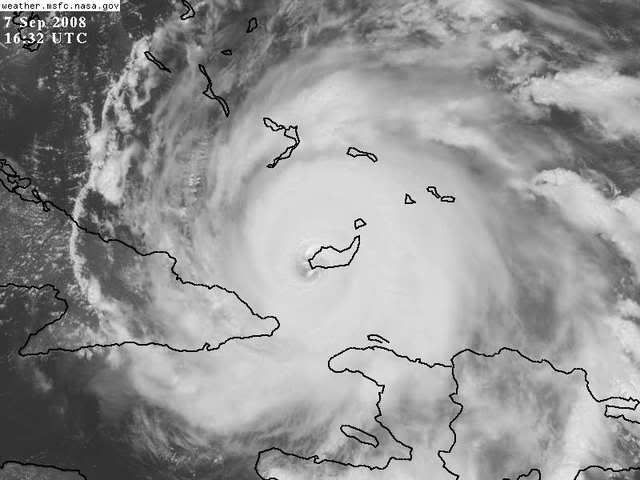
Message: Hurricane Ike impacting Turks and Caicos Islands and the Southeastern Bahamas (As at 11.00 a.m September 7, 2008)
The Event:
Hurricane Ike began impacting Turks and Caicos Islands from Saturday September 6, 2008 as a Category Four Hurricane.
A Hurricane Warning remains in effect for the Turks and Caicos Islands and the southeastern Bahamas including the Acklins, Crooked Island, the Inaguas, Mayaguana and the Ragged Islands, and for the central Bahamas including Cat Island, the Exumas, Long Island, Rum Cay and San Salvador.
At 11.00 a.m today, September 7, 2008 the centre of Hurricane Ike was located near latitude 21.0 North and longitude 73.4 west or about 15 miles (25 km).west-southwest of Great Inagua Island.
Maximum sustained winds are near 135 mph (215 km/hr) with higher gusts. Hurricane force winds extend outward up to 60 miles (95 km) from the center and tropical storm force winds extend outward up to 145 miles (230 km).
Prognosis
Ike is moving toward the west near 13 mph (20 km/hr). A west to west-southwest motion is expected to continue today with a turn toward the west-northwest expected on Monday, September 8, 2008. On this track the core of the hurricane will move through the southeastern Bahamas today.
Turks and Caicos Islands
Impact
Turks and Caicos Islands are still experiencing the effects of Hurricane Ike. Initial reports from the Department of Disasters and Emergencies in Providenciales have stated that there is flooding across the islands. The following were also reported:
Grand Turk:
• Significant housing damage and loss of roofs
• The National Emergency Operations Centre in Grand Turk has lost power
• The hospital in Grand Turk suffered some significant damage
Providenciales:
• The Emergency Operations Centre is operational
• The hospital is operational
• Telephone and electricity services are available. Communication by phone may be difficult due to congestion of the lines
Regional and Other Response:
The CDERA Coordinating Unit has contacted and received updates from representatives of the Pan American Health Organization (PAHO), United Kingdom Department for International Development in the Turks and Caicos Islands and the Bahamas National Emergency Management Agency (NEMA) Director and other senior officials in both Grand Turk and Providenciales.
Plan of Action:
The CDERA CU is in the process of:
• Finalizing arrangements for the first Damage Assessment Team of approximately 6 persons to be deployed from Jamaica by Monday September 8, 2008.
• Mobilizing the CARICOM Disaster Relief Unit (34 military/police) through the Regional Security System (RSS) for possible deployment on Tuesday 9 September, 2008.
• Mobilizing CARELEC for deployment by Wednesday, September 10, 2008 if required.
• Deploying a CDERA Technical Team of approximately 2 persons on Monday, September 9, 2008.
• Mobilizing the Military Engineers from the region to assist with restoration of critical services if required.
DFID is making arrangement for the possible deployment of a humanitarian expert.
The Coordinator will visit the TCI on Monday September 8, 2008 if the conditions permit.
CDERA will continue to monitor and provide updates as necessary.
Contact Details: The CDERA CU 24hr contact number is 1 246 425 0386
ATL: IKE Discussion
Moderator: S2k Moderators
-
expat2carib

- S2K Supporter

- Posts: 458
- Joined: Tue Jul 22, 2008 1:44 pm
- Location: Sint Maarten

-
stayawaynow
- Tropical Low

- Posts: 47
- Joined: Mon Aug 25, 2008 10:07 am
- Location: Wellington, FL.
Re:
KWT wrote:Well at least everything seems to be working in the T&C even though the sad news is a lot of houses are damaged and roofs gone, just hope the damage isn't too exceptional
Let's hope there was no loss of life either.
0 likes

Re: ATL IKE: Category 4 - Discussion
Steering Flow - Appears the ridge might be weakining on it's western side over Florida & the Central & eastern GOM?

0 likes
-
6SpeedTA95
- Category 5

- Posts: 1206
- Joined: Wed Oct 19, 2005 3:25 pm
- Location: Oklahoma
- Contact:
-
cperez1549

- Tropical Low
- Posts: 12
- Age: 39
- Joined: Sun Jul 20, 2008 9:42 am
- Contact:
Re: ATL IKE: Category 4 - Discussion
http://www.mogulus.com/wiv4
Live TV from the Turks and Cacos
Live TV from the Turks and Cacos
0 likes
-
expat2carib
- S2K Supporter
- Posts: 458
- Joined: Tue Jul 22, 2008 1:44 pm
- Location: Sint Maarten
Re:
KWT wrote:Well at least everything seems to be working in the T&C even though the sad news is a lot of houses are damaged and roofs gone, just hope the damage isn't too exceptional
Grand Turk:
• Significant housing damage and loss of roofs
• The National Emergency Operations Centre in Grand Turk has lost power
• The hospital in Grand Turk suffered some significant damage
On Grand Turk it looks like nothing is working!
0 likes
Re: ATL IKE: Category 4 - Discussion
Still 267-ish
Guantanamo should get some winds out of that impressive core HURAKAN showed us on microwave.
If NAM is to verify we should see bumps WNW over the afternoon. (I'm not going to suddenly start taking NAM seriously)
NHC has been very accurate lately so if it verifies Ike should really weaken over the next day or so.
The 1900 storm is a good analogy as far as Texas September climatology.
0 likes
-
HurricaneRobert
- Category 3

- Posts: 812
- Joined: Fri May 18, 2007 9:31 pm
Re:
KWT wrote:jinftl, if only it worked that way but in this situation there is enough of a weakness that even if this does become a mess it should still get decently into the gukf.
As I said before look at the Galveston hurricane, exited Cuba as a TS, peaked in the gulf as a 150mph hurricane, so to think this can't strengthen to a major again, even if it is ruined by Cuba, would be a very foolish move!
That storm started its trip across the islands as a tropical storm. TS can sometimes take more of a punch from land because their structure is a lot looser. I would imagine that it's quite a battle inside the hurricane before the winds near the eyewall start to settle.
0 likes
-
Max_Power

- Tropical Wave

- Posts: 7
- Age: 52
- Joined: Mon Aug 25, 2008 11:57 am
- Location: Ft. Walton Beach, FL
Re: ATL IKE: Category 4 - Discussion
cperez1549 wrote:http://www.mogulus.com/wiv4
Live TV from the Turks and Cacos
I don't think that's live. I saw the same video last night.
0 likes


-
Yankeegirl

- Category 5
- Posts: 3417
- Age: 50
- Joined: Sun May 23, 2004 11:59 pm
- Location: Cy-Fair, Northwest Houston
- Contact:
Re: ATL IKE: Category 4 - Discussion
This storm isnt looking good for Texas.... I dont like the trend of the models...
0 likes
Ah yeah looks like Grand Turk probably took the main eyewall from Ike sadly.
Sanibel, looks to me like its nearly due west I agree, still wobbling a little to the WSW every now and then though pushing the averaged motion still a touch south of west.
Guantanamo will indeed no doubt get some decent gusts!
Sanibel, looks to me like its nearly due west I agree, still wobbling a little to the WSW every now and then though pushing the averaged motion still a touch south of west.
Guantanamo will indeed no doubt get some decent gusts!
0 likes
Re: ATL IKE: Category 4 - Discussion
that sets you up for good news with the trend tomorrow..flip flop flip flop
Yankeegirl wrote:This storm isnt looking good for Texas.... I dont like the trend of the models...
0 likes

Re: ATL IKE: Category 4 - Discussion
Ike was never supposed to take a more northern turn was he? I saw something on TWC that showed a possibility of Ike recurving before fl. Could it turn more east after it comes off Cuba, is there anything in troughs that would prevent Ike from continuing its west track?
There is so much here to read I cant keep up so sorry if this questions has already been asked.
There is so much here to read I cant keep up so sorry if this questions has already been asked.
0 likes
Re: Re:
HurricaneRobert wrote:
That storm started its trip across the islands as a tropical storm. TS can sometimes take more of a punch from land because their structure is a lot looser. I would imagine that it's quite a battle inside the hurricane before the winds near the eyewall start to settle.
Yep indeed though there is a chance that its inner core will be a real mess by the time it leaves land and if thats the case it will probably take a good 24hrs at least I'd guess to sort itself out but when it does sort itself out conditions look good enough for strengthening back towards major status I's imagine.
0 likes
-
6SpeedTA95
- Category 5
- Posts: 1206
- Joined: Wed Oct 19, 2005 3:25 pm
- Location: Oklahoma
- Contact:
Re: ATL IKE: Category 4 - Discussion
Noah wrote:Ike was never supposed to take a more northern turn was he? I saw something on TWC that showed a possibility of Ike recurving before fl. Could it turn more east after it comes off Cuba, is there anything in troughs that would prevent Ike from continuing its west track?
There is so much here to read I cant keep up so sorry if this questions has already been asked.
A couple days ago he was.
0 likes
Re: ATL IKE: Category 4 - Discussion
I saw something on TWC that showed a possibility of Ike recurving before fl. Could it turn more east after it comes off Cuba, is there anything in troughs that would prevent Ike from continuing its west track?
I think the high pressure dome that has pushed Ike to where it is has proven itself. The models were fairly accurate in the last Gulf hurricane, so if this does bend back towards west Florida my guess is it would be at least 175 miles offshore. Slow movers often have the synoptic change over them. But no chance of a curve east of Florida.
The posts in this forum are NOT official forecast and should not be used as such. They are just the opinion of the poster and may or may not be backed by sound meteorological data. They are NOT endorsed by any professional institution or storm2k.org. For official information, please refer to the NHC and NWS products
0 likes
Who is online
Users browsing this forum: No registered users and 75 guests