
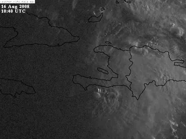
It will be interesting to see how much of a LLC it has left.
There are some 5K-6K high foot mountains parallel to Hispaniola southern coast which may have disrupted the southerly inflow to the LLC. But over all the system looks great, being close to the coast might have helped.
Hopefully Port-au-Prince reports conditions at 12z which should help in trying to figure out where the center is.
ATL: Tropical Depression Fay
Moderator: S2k Moderators
-
Evil Jeremy

- S2K Supporter

- Posts: 5463
- Age: 32
- Joined: Mon Apr 10, 2006 2:10 pm
- Location: Los Angeles, CA


-
Cookiely

- S2K Supporter
- Posts: 3211
- Age: 75
- Joined: Fri Aug 13, 2004 7:31 am
- Location: Tampa, Florida
Re: ATL: Tropical Storm Fay
Cycloneye thank you for posting the great images. For me a picture is worth a thousand words.
0 likes
-
hurricanefloyd5

- Category 5

- Posts: 1659
- Age: 45
- Joined: Sun May 02, 2004 10:53 am
- Location: Spartanburg
- Contact:
Re: ATL: Tropical Storm Fay
EXTENDED...FORECAST WILL OF COURSE DEPEND ON PATH OF TC FAY. 00Z GFS
RUN INDICATES SAME GENERAL MOTION OF NHC TRACK BRINGING IT ACROSS
CUBA EARLY MON AND THROUGH EASTERN GULF NEAR WEST COAST OF FL TUE
INTO WED. THIS PATH WOULD MAKE EC FL IN A REGION OF ENHANCED SHEAR
AND FAVORED FOR TC TORNADOES. HEAVY RAIN ALSO POSSIBLE WITH
PERSISENT RAIN BANDS MOVING OVER EC FL. SINCE THE SYSTEM IS STILL
WRESTLING WITH THE MOUNTAINOUS TERRAIN OF HISPANIOLA AND A FEW DAYS
AWAY FROM REACHING NEAR FL...FORECAST WILL BE SUBJECT TO REVISION.
THE NEW 00Z RUN OF HI-RES ECMWF IS STARTING TO COME IN AND IS AGAIN
DEVIATING FROM IT`S PREVIOUS SOLUTION...SO LOTS OF QUESTIONS REMAIN.
HAVE INDICATED HIGHER POPS AND WINDS IN THE TUE/WED TIME FRAME.
THAT BEING SAID...INTERESTS IN EC FL ARE URGED TO KEEP UP WITH THE
LATEST FORECAST TRACK OF FAY THROUGH THE REMAINDER OF THE WEEKEND.
CHECK FOR THE LATEST STATEMENTS FROM THE NATIONAL WEATHER SERVICE IN
MELBOURNE AND NATIONAL HURRICANE CENTER IN MIAMI.
0 likes
-
Shockwave
- Tropical Storm

- Posts: 167
- Joined: Fri Jul 25, 2008 7:33 am
- Location: Lafayette, TN
- Contact:
Re: ATL: Tropical Storm Fay
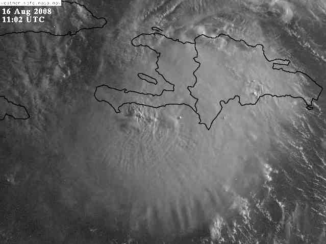
This system is becoming more of a concern. With the land impact of PR and Haiti not really causing it much harm, it has now moved over water and I see a RAPID intensification process for later on today. Those are already some intense t'storm's that have formed in Fay and that will only continue to go up as the day goes on. Am I correct?
0 likes
-
cycloneye

- Admin

- Posts: 149371
- Age: 69
- Joined: Thu Oct 10, 2002 10:54 am
- Location: San Juan, Puerto Rico
Re: ATL: Tropical Storm Fay
Cookiely wrote:Cycloneye thank you for posting the great images. For me a picture is worth a thousand words.
Thanks for your kind words,but I think HURAKAN also posts great images and graphics that we have to give big credit.
0 likes

Re: ATL: Tropical Storm Fay
South Florida is the target of the new GFS run. I am going to go out and get some supplies later this morning, and I will report on how the rest of Broward County is taking this possible threat.
Looks like the archer is starting to set the bow.
I am afraid points further north will see the point of the arrow as it rises toward north Florida.
Plenty of time to shift the early track further west not much time to board up in south Florida.
A recurve late in the forecast would still bring the storm in near the big bend of Florida even if it got west of 85, but that might spare south and mid west coast Florida.
Last edited by Nimbus on Sat Aug 16, 2008 6:22 am, edited 1 time in total.
0 likes
-
superfly

-
Emmett_Brown

- Category 5
- Posts: 1433
- Joined: Wed Aug 24, 2005 9:10 pm
- Location: Sarasota FL
Re:
HURAKAN wrote:REPEATING THE 800 AM EDT POSITION...18.8 N...72.8 W. MOVEMENT
TOWARD...WEST NEAR 14 MPH. MAXIMUM SUSTAINED WINDS...45 MPH.
MINIMUM CENTRAL PRESSURE...1007 MB.
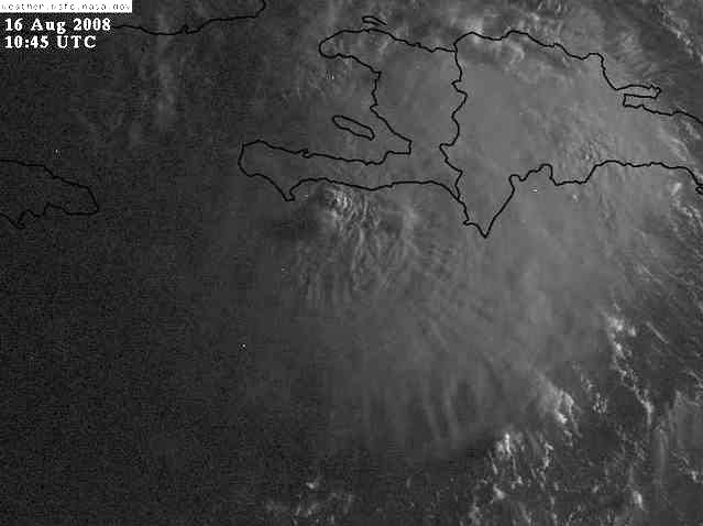
That position would mean Fay is about to re-emerge near Port-Au-Prince, to the north of the peninsula. The large mountains there could help limit inflow from the south keeping Fay in check for today.
0 likes
Re: ATL: Tropical Storm Fay
I did not think the models did that well with ULL's but I am wondering if that is why the move N over Cuba.The little guy has been there a while.
http://www.atmos.washington.edu/~ovens/ ... nhanced+12
http://www.atmos.washington.edu/~ovens/ ... nhanced+12
0 likes
Re: ATL: Tropical Storm Fay
Quite possibly, but I'm even more worried about after it emerges from Cuba and moves past the Keys. That's exactly where Charley ended up intensifying at an almost unprecedented rate. I should check the forecasted shear around then, but as far as I know there's no major negatives for intensification there. If there's a trough, even though it may not be very distinct down there, it might help ventilate the system and aid in the intensification. Not to mention passing over the loop, or the in/outflow current feeding it (part of the gulf stream through the Florida straights).
Shockwave wrote:This system is becoming more of a concern. With the land impact of PR and Haiti not really causing it much harm, it has now moved over water and I see a RAPID intensification process for later on today. Those are already some intense t'storm's that have formed in Fay and that will only continue to go up as the day goes on. Am I correct?
0 likes
Who is online
Users browsing this forum: No registered users and 33 guests