ATL: Tropical Depression Fay
Moderator: S2k Moderators


Re: ATL: Tropical Storm Fay
Nervous mama here...my daughter is leaving for FSU (Tallahassee) tomorrow. Sorority Recruitment (Rush Week) starts on Monday - my daughter is rushing. She'll be staying at my aunt's house in northern Tallahassee until she is able to move into her apartment on Wednesday (yeah the timing really bites). I'd assume that some of the FSU buildings are designated as shelters? Obviously she won't stay if this thing turns major and continues on that course towards Tallahassee...
0 likes
-
lonelymike
- S2K Supporter

- Posts: 634
- Joined: Sat Jul 26, 2008 10:12 am
- Location: walton county fla
Re: ATL: Tropical Storm Fay
Tallahassee has one of the best prepared emergency management depts in Fla. FSU has several designated shelters. I would go ahead and send your daughter on current forecasts this won't be affecting Tally that much at all. Anyways she may not forgive you for a while if she misses Rush Week. One of the best memories of college without the drinking of course 
0 likes


-
lonelymike
- S2K Supporter
- Posts: 634
- Joined: Sat Jul 26, 2008 10:12 am
- Location: walton county fla
-
Emmett_Brown

- Category 5

- Posts: 1433
- Joined: Wed Aug 24, 2005 9:10 pm
- Location: Sarasota FL
Re: ATL: Tropical Storm Fay
physicx07 wrote:Quite possibly, but I'm even more worried about after it emerges from Cuba and moves past the Keys. That's exactly where Charley ended up intensifying at an almost unprecedented rate. I should check the forecasted shear around then, but as far as I know there's no major negatives for intensification there. If there's a trough, even though it may not be very distinct down there, it might help ventilate the system and aid in the intensification. Not to mention passing over the loop, or the in/outflow current feeding it (part of the gulf stream through the Florida straights).Shockwave wrote:This system is becoming more of a concern. With the land impact of PR and Haiti not really causing it much harm, it has now moved over water and I see a RAPID intensification process for later on today. Those are already some intense t'storm's that have formed in Fay and that will only continue to go up as the day goes on. Am I correct?
True. Waters in the straights are historically a place for RI. However, Fay has yet to get a real inner core (so much land interaction). Today will be a defining day IMO. If the central circulation gets well established, then would mean it could take better advantage of the high octane fuel of the straights. If it remains disorganized, then it may not have enough time over water to become a monster. Today and tonight are very important.
0 likes
-
Evil Jeremy

- S2K Supporter
- Posts: 5463
- Age: 32
- Joined: Mon Apr 10, 2006 2:10 pm
- Location: Los Angeles, CA
Re: TS Fay Personal forecasts
Personal Forecast Disclaimer:
The posts in this forum are NOT official forecast and should not be used as such. They are just the opinion of the poster and may or may not be backed by sound meteorological data. They are NOT endorsed by any professional institution or storm2k.org. For official information, please refer to the NHC and NWS products.
Although it is over very mountainous terrain at the moment, satellite and radar imagery, as well as other reports suggest that Tropical Storm Fay is maintaining its strength and organization. Currently, Fay is estimated to have winds of 45 MPH and a pressure of 1007 MB.
Since Fay is inland, and satellite is not much use early in the morning, it is difficult to tell the movement of Fay. However, I am estimating that Fay is currently moving at 275 degrees at close to 15 MPH. A turn to the WNW should commence within 12 hours, followed by a NW path tomorrow. However, if Fay gains more strength than expected, she can more northward earlier.
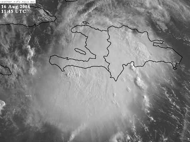
The official center of Fay is at 18.8 North and 72.8 West.
Fay’s wind field currently extends outwards to about 100 miles. This could increase today as the system gets stronger.
The future path of Fay is a highly uncertain one. Over the past few days, the computer models have been flopping all over the place, from off the coast of Eastern Florida, into the Eastern Gulf of Mexico. The latest computer model runs of the UKMET, CMC, and other models take the storm right up the west coast of Florida into the big bend area. However, the latest runs of the GFS, HWRF, and GFDL models take the storm into southern Florida.
The cone that I drew up for this forecast is simple: All of Florida is in the 5 day cone. That is because all of Florida should be keeping its eye on the progress of Fay. Any minor change with the storm could bring your city further into the cone. Even if Fay does not make landfall in your area, as it will likely (at this point) ride up the west coast of the state, you will still be affected by rain or wind.
The forecast cone will be influenced partially by the intensity of the storm at any given moment, as a stronger storm could mean a more eastward cone.
Fay will be moving over some of the warmest waters in the world over the next 3 days with very little shear, so it is very possible to see a hurricane come out of Fay. It is possible that Fay can become stronger than a Category 1 hurricane, but I am only strengthening it to one at the moment because of the uncertainty of where Fay will end up.
INITIAL 45 MPH
12HR VT 55 MPH
24HR VT 65 MPH
36HR VT 75 MPH
48HR VT 80 MPH
72HR VT 85 MPH
96HR VT 90 MPH (Inland?)
120HR VT 50 MPH (Inland?)

The posts in this forum are NOT official forecast and should not be used as such. They are just the opinion of the poster and may or may not be backed by sound meteorological data. They are NOT endorsed by any professional institution or storm2k.org. For official information, please refer to the NHC and NWS products.
Although it is over very mountainous terrain at the moment, satellite and radar imagery, as well as other reports suggest that Tropical Storm Fay is maintaining its strength and organization. Currently, Fay is estimated to have winds of 45 MPH and a pressure of 1007 MB.
Since Fay is inland, and satellite is not much use early in the morning, it is difficult to tell the movement of Fay. However, I am estimating that Fay is currently moving at 275 degrees at close to 15 MPH. A turn to the WNW should commence within 12 hours, followed by a NW path tomorrow. However, if Fay gains more strength than expected, she can more northward earlier.
The official center of Fay is at 18.8 North and 72.8 West.
Fay’s wind field currently extends outwards to about 100 miles. This could increase today as the system gets stronger.
The future path of Fay is a highly uncertain one. Over the past few days, the computer models have been flopping all over the place, from off the coast of Eastern Florida, into the Eastern Gulf of Mexico. The latest computer model runs of the UKMET, CMC, and other models take the storm right up the west coast of Florida into the big bend area. However, the latest runs of the GFS, HWRF, and GFDL models take the storm into southern Florida.
The cone that I drew up for this forecast is simple: All of Florida is in the 5 day cone. That is because all of Florida should be keeping its eye on the progress of Fay. Any minor change with the storm could bring your city further into the cone. Even if Fay does not make landfall in your area, as it will likely (at this point) ride up the west coast of the state, you will still be affected by rain or wind.
The forecast cone will be influenced partially by the intensity of the storm at any given moment, as a stronger storm could mean a more eastward cone.
Fay will be moving over some of the warmest waters in the world over the next 3 days with very little shear, so it is very possible to see a hurricane come out of Fay. It is possible that Fay can become stronger than a Category 1 hurricane, but I am only strengthening it to one at the moment because of the uncertainty of where Fay will end up.
INITIAL 45 MPH
12HR VT 55 MPH
24HR VT 65 MPH
36HR VT 75 MPH
48HR VT 80 MPH
72HR VT 85 MPH
96HR VT 90 MPH (Inland?)
120HR VT 50 MPH (Inland?)
0 likes
-
hurricanefloyd5

- Category 5
- Posts: 1659
- Age: 45
- Joined: Sun May 02, 2004 10:53 am
- Location: Spartanburg
- Contact:
Re: ATL: Tropical Storm Fay
.DAYS TWO THROUGH SEVEN...SUNDAY THROUGH FRIDAY.
TROPICAL STORM FAY NEAR HISPANIOLA IS FORECAST TO MOVE OVER CUBA
THIS WEEKEND AND APPROACH SOUTHERN FLORIDA MONDAY INTO TUESDAY.
WHILE THERE IS STILL SOME UNCERTAINTY IN THE EVENTUAL PATH OF
FAY...PERSONS IN EAST CENTRAL FLORIDA SHOULD REVIEW PROCEDURES
FOR WHEN A TROPICAL SYSTEM THREATENS. KEEP INFORMED OF THE LATEST
UPDATES CONCERNING TROPICAL STORM FAY FROM THE NATIONAL HURRICANE
CENTER...AND THE NATIONAL WEATHER SERVICE OFFICE IN MELBOURNE.
0 likes

-
hurricanefloyd5
- Category 5
- Posts: 1659
- Age: 45
- Joined: Sun May 02, 2004 10:53 am
- Location: Spartanburg
- Contact:
Re:
RL3AO wrote:Why do you keep highlighting that in large bold print?
casue it's pointing out the weather office it's coming from!!!!!!!!
0 likes


-
gatorcane

- S2K Supporter
- Posts: 23708
- Age: 48
- Joined: Sun Mar 13, 2005 3:54 pm
- Location: Boca Raton, FL
well one things is for sure. Fay has handled Hispaniola very well. It just shows what a great upper-level environment can do for a tropical system. Most of the convection is still on the South side of the NHC center. As Fay moves West, and gets away from the mountain influence which is disrupting its ability to "wrap" convection from SE to NW....I think we'll see quite a bit more convection flare up on the NE and northern side....
0 likes

Re: Re:
Emmett_Brown wrote:HURAKAN wrote:REPEATING THE 800 AM EDT POSITION...18.8 N...72.8 W. MOVEMENT
TOWARD...WEST NEAR 14 MPH. MAXIMUM SUSTAINED WINDS...45 MPH.
MINIMUM CENTRAL PRESSURE...1007 MB.
That position would mean Fay is about to re-emerge near Port-Au-Prince, to the north of the peninsula. The large mountains there could help limit inflow from the south keeping Fay in check for today.
Actually, is well west of Port-Au-Prince by those coordinates, about 40 milse NW, over that Island. But looking at the Cuban radar it might be a littl to the SW of that closer to the Peninsula, IMO.
0 likes
Re: ATL: Tropical Storm Fay
I'm wondering if the MLC is offshore south of the Haitian peninsula and the LLC futher north. If so, still not co-located and probably won't strengthen significantly until they do.
0 likes
-
jabber

- Category 2

- Posts: 688
- Joined: Mon Mar 24, 2003 5:36 pm
- Location: Raleigh, NC (former Boynton Beach, Fl)
Re:
HURAKAN wrote:
Look at that towering cloud. Impressive. Remember that this was the area where Ernesto first rapidly intensified and then lost intensity due to shear and the interaction with land.
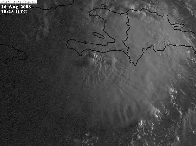
Wow that almost looks 3D. No wonder the flight crew had such a bumpy ride.
0 likes
-
gatorcane
- S2K Supporter
- Posts: 23708
- Age: 48
- Joined: Sun Mar 13, 2005 3:54 pm
- Location: Boca Raton, FL
Well the heights across FL must be above the low-levels. I'm checking out observations across the SE Coast of FL and the winds are WEAK. That almost always indicates weak ridging around Southern FL. If storms pass us by to the south, almost always you see winds out of the E or SE much strong than that. I will monitor these winds over the next couple of days 
NAPLES PTCLDY 77 74 90 NE3 30.01R
W PALM BEACH PTCLDY 77 71 82 CALM 30.00S
FT LAUDER-EXEC CLEAR 78 75 90 CALM 30.01R
FT LAUDERDALE PTCLDY 81 73 76 NW3 30.00S
POMPANO BEACH CLEAR 78 76 93 CALM 30.01R
OPA LOCKA CLEAR 79 75 87 N5 30.01R
MIAMI PTCLDY 81 75 82 VRB3 30.01R
WEST KENDALL PTCLDY 74 74 100 CALM 30.01R
HOMESTEAD PTCLDY 77 74 90 CALM 30.01R FOG
0 likes
-
jlauderdal
- S2K Supporter
- Posts: 7240
- Joined: Wed May 19, 2004 5:46 am
- Location: NE Fort Lauderdale
- Contact:
Re:
gatorcane wrote:well one things is for sure. Fay has handled Hispaniola very well. It just shows what a great upper-level environment can do for a tropical system. Most of the convection is still on the South side of the NHC center. As Fay moves West, and gets away from the mountain influence which is disrupting its ability to "wrap" convection from SE to NW....I think we'll see quite a bit more convection flare up on the NE and northern side....
it handled it well because it took the southerly route away from land
0 likes
-
DESTRUCTION5

- Category 5
- Posts: 4430
- Age: 44
- Joined: Wed Sep 03, 2003 11:25 am
- Location: Stuart, FL
Re:
gatorcane wrote:Well the heights across FL must be above the low-levels. I'm checking out observations across the SE Coast of FL and the winds are WEAK. That almost always indicates weak ridging around Southern FL. If storms pass us by to the south, almost always you see winds out of the E or SE much strong than that. I will monitor these winds over the next couple of days
NAPLES PTCLDY 77 74 90 NE3 30.01R
W PALM BEACH PTCLDY 77 71 82 CALM 30.00S
FT LAUDER-EXEC CLEAR 78 75 90 CALM 30.01R
FT LAUDERDALE PTCLDY 81 73 76 NW3 30.00S
POMPANO BEACH CLEAR 78 76 93 CALM 30.01R
OPA LOCKA CLEAR 79 75 87 N5 30.01R
MIAMI PTCLDY 81 75 82 VRB3 30.01R
WEST KENDALL PTCLDY 74 74 100 CALM 30.01R
HOMESTEAD PTCLDY 77 74 90 CALM 30.01R FOG
If it were noonish...ECSB dont kick at 830 AM
0 likes
-
Lowpressure

- S2K Supporter
- Posts: 2032
- Age: 59
- Joined: Sun Sep 14, 2003 9:17 am
- Location: Charlotte, North Carolina
Re: ATL: Tropical Storm Fay
Fay has been difficult to follow to this point. I still think the final LLC has yet to be determined, but that thunderstrom cluster of the southern coast is very impressive, even considering the sun angle. Upper air dynamics and pattern look like a much stronger storm. Most storms seem to have a better LLC and wait until the upper dynamics come into place. Fay is just the opposite. It will be very interesting to follow this with such dynamics in place that mountain ranges did not hinder the system. Maybe no real LLC is why is did so well over DR, nothing to really disrupt.
Last edited by Lowpressure on Sat Aug 16, 2008 7:29 am, edited 2 times in total.
0 likes
Who is online
Users browsing this forum: No registered users and 33 guests