Wow! That is some crazy storm surge.
ATL: IKE Discussion
Moderator: S2k Moderators
-
cape_escape

- Category 2

- Posts: 745
- Age: 57
- Joined: Fri Aug 13, 2004 2:39 am
- Location: Cape Coral Florida
- Contact:
-
alan1961

- Category 2
- Posts: 771
- Joined: Mon Mar 20, 2006 11:58 am
- Location: Derby, Derbyshire, England
- Contact:
Re: ATL IKE: Category 2 - Discussion
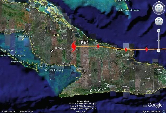
wont be surprised too see a ragged mess of Ike when and where he exits Cuba.
0 likes

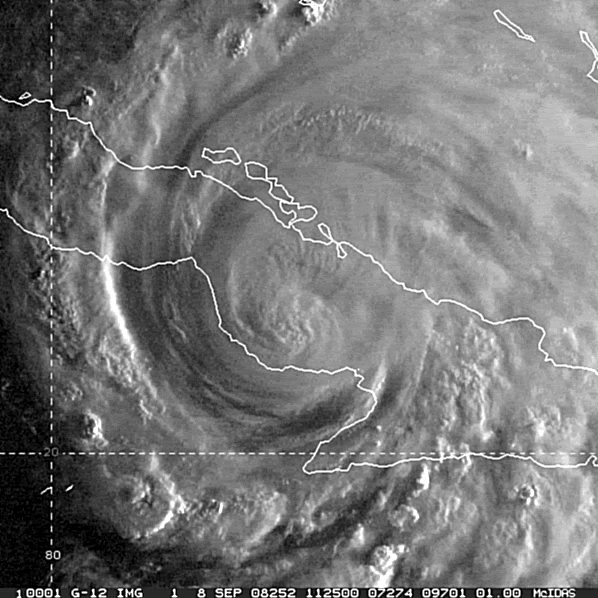
Looks like as expected Ike's inner core is starting to really suffer, it probably will get into the Caribbean but even then I'd expect Ike to be no more then 40-50kts when it exits from Cuba probably as a big mess of a tropical storm...what happens after that is the big question, who knows how quickly it may or may not ram pup.
0 likes


-
Evil Jeremy

- S2K Supporter

- Posts: 5463
- Age: 32
- Joined: Mon Apr 10, 2006 2:10 pm
- Location: Los Angeles, CA
-
Lowpressure

- S2K Supporter
- Posts: 2032
- Age: 59
- Joined: Sun Sep 14, 2003 9:17 am
- Location: Charlotte, North Carolina
Re:
KWT wrote:Looks like as expected Ike's inner core is starting to really suffer, it probably will get into the Caribbean but even then I'd expect Ike to be no more then 40-50kts when it exits from Cuba probably as a big mess of a tropical storm...what happens after that is the big question, who knows how quickly it may or may not ram pup.
Core may be starting to disrupt, but looking at cycloneye first visible, everything else looks great. Should not take long to regenerate.
0 likes
-
stayawaynow
- Tropical Low

- Posts: 47
- Joined: Mon Aug 25, 2008 10:07 am
- Location: Wellington, FL.
Re:
Evil Jeremy wrote:Living in Broward County, what effects can I expect from Ike over the next few days in terms of wind and rain?
Tropical Weather Statement
/O.NEW.KMFL.HU.S.0002.080908T1012Z- 000000T0000Z/ COASTAL BROWARD-COASTAL COLLIER-COASTAL MIAMI DADE- COASTAL PALM BEACH-FAR SOUTH MIAMI DADE-GLADES- HENDRY- INLAND BROWARD-INLAND COLLIER- INLAND MIAMI DADE-INLAND PALM BEACH- MAINLAND MONROE-METRO BROWARD-METRO MIAMI DADE-METRO PALM BEACH- 612 AM EDT MON SEP 8 2008
AT THIS TIME NO WATCHES OR WARNINGS ARE IN EFFECT FOR MAINLAND SOUTH FLORIDA. MAINLAND SOUTH FLORIDA IS EXPECTED TO EXPERIENCE PERIPHERAL EFFECTS FROM HURRICANE IKE THIS AFTERNOON THROUGH WEDNESDAY WITH GUSTY WINDS AND OCCASIONAL SQUALLS ASSOCIATED WITH THE OUTER SPIRAL BANDS OF IKE.
...AREAS AFFECTED...
THIS STATEMENT RECOMMENDS ACTIONS TO BE TAKEN BY PERSONS IN THE FOLLOWING COUNTIES OR MARINE AREAS:
COASTAL BROWARD...COASTAL COLLIER... COASTAL MIAMI DADE... COASTAL PALM BEACH...FAR SOUTH MIAMI DADE... GLADES...HENDRY... INLAND BROWARD... INLAND COLLIER...INLAND MIAMI DADE... INLAND PALM BEACH...MAINLAND MONROE...METRO BROWARD...METRO MIAMI DADE...METRO PALM BEACH.
...WATCHES/WARNINGS...
NO ADDITIONAL HAZARDS ARE IN EFFECT.
...PRECAUTIONARY/PREPAREDNESS ACTIONS...
RESIDENTS OF MAINLAND SOUTH FLORIDA SHOULD REMAIN VIGILANT AND KEEP UP WITH THE LATEST INFORMATION ON HURRICANE IKE AS IT PASSES ACROSS CUBA AND INTO THE SOUTHWEST GULF OF MEXICO TODAY THROUGH WEDNESDAY.
...STORM SURGE AND STORM TIDE...
DEPENDING ON THE EXACT TRACK OF HURRICANE IKE AFTER IT LEAVES CUBA AND ENTERS THE SOUTHEAST GULF OF MEXICO, STORM TIDE OF 2 TO 4 FEET ABOVE MEAN SEA LEVEL IS POSSIBLE ALONG THE SOUTHWEST FLORIDA GULF COAST MAINLY TUESDAY AND WEDNESDAY. THE STORM TIDE WILL BE HIGHEST AT THE TIMES OF NORMAL HIGH TIDE AND ESPECIALLY ALONG THE COAST FROM MARCO ISLAND EAST TO CHOKOLOSKEE AND FROM CAPE SABLE EAST TO FLAMINGO. ELSEWHERE STORM TIDES OF 1 TO 2 FEET ABOVE NORMAL CAN BE EXPECTED ESPECIALLY WITH ONSHORE WINDS TODAY AND TUESDAY.
...WINDS...
NORTHEAST WINDS ACROSS MAINLAND SOUTH FLORIDA WILL SLOWLY INCREASE TO 15 TO 25 MPH WITH HIGHER GUSTS ESPECIALLY IN SQUALLS ASSOCIATED WITH THE SPIRAL BANDS ROTATING ONSHORE THE ATLANTIC COAST THIS AFTERNOON THROUGH TUESDAY. WINDS WILL VEER TO THE EAST ON TUESDAY AND SOUTHEAST TUESDAY NIGHT AS IKE PASSES ACROSS CUBA AND ENTERS THE SOUTHEAST GULF OF MEXICO. TROPICAL STORM FORCE WIND GUSTS, 39 MPH OR HIGHER, WILL BE LIKELY ESPECIALLY IN SQUALLS ON TUESDAY AND TUESDAY NIGHT INTO WEDNESDAY MORNING.
...PROBABILITY OF HURRICANE/TROPICAL STORM CONDITIONS...
FOR MIAMI FL...
THERE IS ABOUT A 23 PERCENT CHANCE OF TROPICAL STORM FORCE WINDS, 39 MPH OR GREATER, THROUGH WEDNESDAY.
FOR W PALM BEACH FL...
THERE IS ABOUT A 17 PERCENT CHANCE OF TROPICAL STORM FORCE WINDS, 39 MPH OR GREATER, THROUGH WEDNESDAY.
FOR NAPLES FL...
THERE IS ABOUT A 35 PERCENT CHANCE OF TROPICAL STORM FORCE WINDS, 39 MPH OR GREATER, THROUGH WEDNESDAY.
...INLAND FLOODING...
2 TO 4 INCHES OF RAIN WILL BE POSSIBLE ACROSS MAINLAND SOUTH FLORIDA THROUGH WEDNESDAY WITH LOCALLY HIGHER AMOUNTS POSSIBLE ESPECIALLY IF THE SPIRAL BANDS OF SQUALLS CONTINUALLY TRAIN ACROSS THE SAME AREA FOR SEVERAL HOURS.
...TORNADOES...
MAINLAND SOUTH FLORIDA WILL BE IN A FAVORED LOCATION FOR BRIEF QUICK STRIKING TORNADOES ASSOCIATED WITH THE SPIRAL BANDS OF SQUALLS OF HURRICANE IKE BEGINNING THIS AFTERNOON LASTING THROUGH WEDNESDAY.
...NEXT UPDATE...
THIS STATMENT WILL BE UPDATED AROUND NOON EDT.
0 likes

Re: ATL IKE: Category 2 - Discussion
On sat does it look like Ike is moving north of due west now as it was due west earlier.
http://www.ssd.noaa.gov/goes/flt/t4/loop-rb.html
http://www.ssd.noaa.gov/goes/flt/t4/loop-rb.html
0 likes

Re: ATL IKE: Category 2 - Discussion
Ike wants to go Into the NW Caribbean. I don't think he'll ride the spine of Cuba judging by the sat pics.
0 likes
-
deltadog03

- Professional-Met

- Posts: 3580
- Joined: Tue Jul 05, 2005 6:16 pm
- Location: Macon, GA


Re: ATL IKE: Category 2 - Discussion
I think the Yucatan will have to deal with Ike too. It doesn't look like he wants to move other than due west.
0 likes
-
alan1961
- Category 2
- Posts: 771
- Joined: Mon Mar 20, 2006 11:58 am
- Location: Derby, Derbyshire, England
- Contact:
Re: ATL IKE: Category 3 - Discussion
Sean in New Orleans wrote:El Nino wrote:Houston, we have a problem !
Maybe...that's a five day NHC forecast. We all have lots of watching to do this week. I can report that Gov. Bobby Jindal of Louisiana officially declared a State of Emergency this afternoon around 4:00 due to Ike.
yes and that man should be watching his p's and q's this time..remember his words with Gustav?...''people get scared'' and ''storm of the century''..he's a mayor of a big American city and should have responsibility not to scare the c**p out of everybody there..leave that to the media hype..and yes it was witnessed over here in England..sorry for the rant, just couldn't understand anyone with responsibilities like he has.
0 likes
-
bob rulz
- Category 5

- Posts: 1711
- Age: 35
- Joined: Sat Jan 28, 2006 7:30 pm
- Location: Salt Lake City, Utah
Re: ATL IKE: Category 3 - Discussion
alan1961 wrote:Sean in New Orleans wrote:El Nino wrote:Houston, we have a problem !
Maybe...that's a five day NHC forecast. We all have lots of watching to do this week. I can report that Gov. Bobby Jindal of Louisiana officially declared a State of Emergency this afternoon around 4:00 due to Ike.
yes and that man should be watching his p's and q's this time..remember his words with Gustav?...''people get scared'' and ''storm of the century''..he's a mayor of a big American city and should have responsibility not to scare the c**p out of everybody there..leave that to the media hype..and yes it was witnessed over here in England..sorry for the rant, just couldn't understand anyone with responsibilities like he has.
Actually you're thinking of Mayor Ray Nagin of New Orleans.
Bobby Jindal to me actually seemed like a very straightforward and honest presenter of the info.
0 likes
Who is online
Users browsing this forum: No registered users and 62 guests