wxman57 wrote:Noles2006 wrote:So... it's a little ESE of the 2 p.m. position...
That vortex has dissipated.
Right, I understand that (I didn't mean for it to sound like I thought it had moved ESE, lol)
Moderator: S2k Moderators


wxman57 wrote:Noles2006 wrote:So... it's a little ESE of the 2 p.m. position...
That vortex has dissipated.
StJoe wrote:Looks to me like she's startring her nw turn
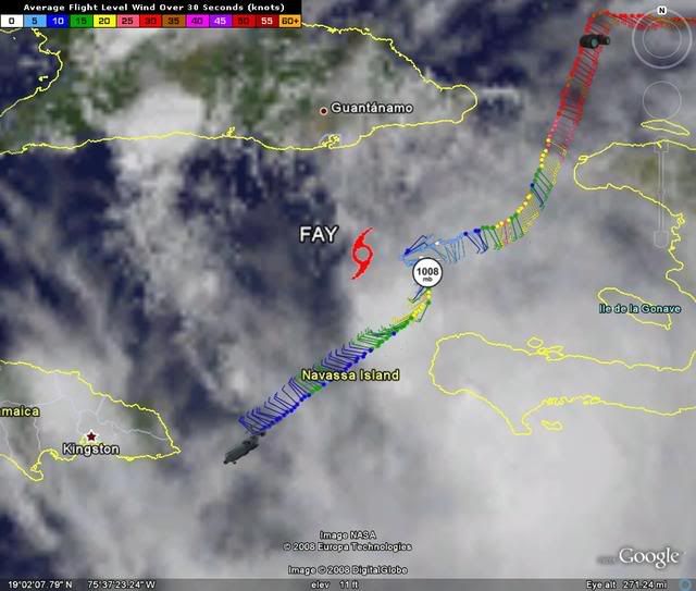
http://www.ssd.noaa.gov/goes/flt/t1/loop-avn.html


ekal wrote:UNDERCAST
In aviation, it is an opaque cloud layer viewed from an observation point above the layer. From the ground, it would be considered an overcast.
From weatherdictionary.com
I imagine the cloud cover prevented a visual fix of the center. They must have supplied the VDM position based upon the location of the pressure minimum coupled with radar data.


StJoe wrote:Looks to me like she's startring her nw turn
http://www.ssd.noaa.gov/goes/flt/t1/loop-avn.html
I personally think that she is est of her forecast track right now, but who knows?

Extremeweatherguy wrote:Yes, this image confirms it. The center is definitely further ESE.HURAKAN wrote:
marciacubed wrote:Is that a reformation or a SE movement?
Derek Ortt wrote:this confirms my thoughts of utterly chucking the GFDL
carversteve wrote:Derek Ortt wrote:this confirms my thoughts of utterly chucking the GFDL
Is the GFDL the furthest east of the models?..sorry don't remeber.
Users browsing this forum: No registered users and 14 guests