No, if anything with this trend eastward this thing might cut right across South Florida.Bocadude85 wrote:so I should be safe here on the se coast of fl?
ATL: Tropical Depression Fay
Moderator: S2k Moderators
-
Jason_B
Re: ATL: Tropical Storm Fay
0 likes


Re: ATL: Tropical Storm Fay
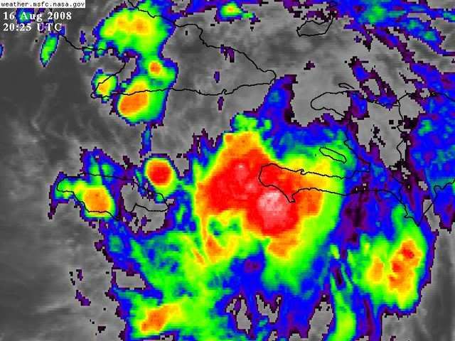
According to that graphic, Luis, the new center is slightly west and south of the forecast point.
0 likes
-
Tampa Bay Hurricane

- Category 5

- Posts: 5597
- Age: 38
- Joined: Fri Jul 22, 2005 7:54 pm
- Location: St. Petersburg, FL

Re: ATL: Tropical Storm Fay
With such a disrupted LLC my thinking was it might decide to recenter over the convection. That reasoning might suggest that it tracks over the water between Jamaica and Cuba.
0 likes

Re: ATL: Tropical Storm Fay
a west coast landfall could still very well mean tropical storm conditions on the se coast of the state....i think the wind field will be quite a bit larger than charley's was....
Bocadude85 wrote:so I should be safe here on the se coast of fl?
0 likes
-
Tampa Bay Hurricane
- Category 5
- Posts: 5597
- Age: 38
- Joined: Fri Jul 22, 2005 7:54 pm
- Location: St. Petersburg, FL
-
gatorcane

- S2K Supporter

- Posts: 23708
- Age: 48
- Joined: Sun Mar 13, 2005 3:54 pm
- Location: Boca Raton, FL
Re:
capepoint wrote:NOT A REAL FORECAST BY NOT A REAL FORECASTER....
Shift a little east. Over central to east cuba, southern fl exiting into atl near palm beach then off to hatteras.
just a gut feeling..not even going to try to back it up.
wouldn't be great if it misses FL to the East all together and misses the Carolinas?
0 likes


Re: ATL: Tropical Storm Fay
NAM 66 hur point..landfall around Naples/Marco Island early Tuesday Morning....Compared to Off the coast of Palm Beach on the 12z run...that is roughly a 150 jump in one model run. Also...NAM in general shows a pretty nasty storm down there too. Again, I only bring you all this as it either means NAM is just catching up to the other models...or we may see a shift back west on this evening's models. The center reformation SW of haiti lends some possbility to this.
0 likes
-
Derek Ortt
Re: ATL: Tropical Storm Fay
Jason_B wrote:No, if anything with this trend eastward this thing might cut right across South Florida.Bocadude85 wrote:so I should be safe here on the se coast of fl?
what trend eastward? The only models that have this hitting Miami are already wrong!
0 likes
-
TCmet
- Professional-Met

- Posts: 106
- Age: 45
- Joined: Sat Jul 14, 2007 4:00 pm
- Location: New York, NY
- Contact:
Re: ATL: Tropical Storm Fay
Nimbus wrote:With such a disrupted LLC my thinking was it might decide to recenter over the convection. That reasoning might suggest that it tracks over the water between Jamaica and Cuba.
This is close to what I'm thinking. plus, convection should stay more consistent in the southern semicircle as it approaches Cuba with land to the north.
0 likes
-
SkeetoBite

- S2K Supporter
- Posts: 515
- Age: 60
- Joined: Fri Sep 03, 2004 8:25 am
- Contact:
Re: ATL: Tropical Storm Fay

1. Sanibel Island is south of the 72hr plot, right under the Cape Coral label and left of the Fort Myers label
2. Presumably, there will be a decent size eye, meaning there will be a single landfall around Venice and then scraping over Tampa bay. If this track verifies, the entire bay will be within the eye
3. Charley came ashore at an island called Cayo Costa (just above the Cape Coral label on the map), tens of miles north of Sanibel and tens of miles south of Venice
4. The forecast wind field is included so folks don’t use the line as a guide. We drop the line 24 hours prior to landfall
5. This system is forecast to be pretty large (based on the wind field, hence the statements that the entire area could be affected by TS strength winds
ALWAYS REFER TO OFFICIAL DATA FROM THE NATIONAL HURRICANE CENTER. TAKE PROMPT ACTION WHEN NOTICES ARE ISSUED FROM YOUR LOCAL EMERGENCY MANAGEMENT OFFICE.
Last edited by SkeetoBite on Sat Aug 16, 2008 3:55 pm, edited 1 time in total.
0 likes
Re: ATL: Tropical Storm Fay
Sanibel is the little island that yellow line first hits in Florida. About 2 miles east of my roof. 
0 likes

Who is online
Users browsing this forum: No registered users and 13 guests