ATL: IKE Discussion

Moderator: S2k Moderators

Message
Author
jinftl
Category 5
Category 5
Posts: 4312
Joined: Tue Aug 31, 2004 4:47 pm
Location: fort lauderdale, fl

Re: ATL IKE: Category 2 - Discussion

#5521 Postby jinftl » Mon Sep 08, 2008 12:55 pm

Now Texans are getting a bad rap....never as bad as the one floridians have here in geneal though....and south floridians for sure have a bad connotation although i am not ever sure why...could just the the large number of us.

Who cares where people are from...all that matters is where they are...and that is participating and learning on S2k! PLus -removed- is an equal opportunity hobby....florida folks had there turn, now the GoMers are passed that baton.

smw1981 wrote:
gatorcane wrote:what happened to all of the Florida posters? It's interesting to note that one can quickly parse the active tropics page looking for usernames to quickly see where a storm may be threatening.

In this case I see alot of LA and Texas posters so without even looking at the NHC track, I know where the system may be heading...


I said something about this during Gustav and was told by a Mod that it wasn't their fault that there are more Texas members than MGC, AL, and FL panhandle....

Also, I think (actually know) that people get tired of all of the Texas folks saying "it is coming here". Not that MGC, LA, Alabama and FL people don't say that, there are just more Texans so therefore it gets said over and over and over again. Someone PMed me last night saying this is exactly what happened with Gustav and it didn't even rain in TX...no use sticking around listening (reading) all of that.

Please do not yell at me for saying all of this....like I said, everyone else does it too!
0 likes   

User avatar
KWT
Category 5
Category 5
Posts: 31415
Joined: Tue Aug 17, 2004 11:02 am
Location: UK!!!

#5522 Postby KWT » Mon Sep 08, 2008 12:56 pm

With regards to strengthen upto landfall, remember a cat-1 strengthening towards a 2, like Dolly actually did and Humberto came close, is quite a different beast to a cat-3/4, which won't strengthen upto landfall because the waters are still fairly shallow.
0 likes   

N2Storms
Category 1
Category 1
Posts: 324
Joined: Thu Sep 04, 2003 1:37 pm
Location: Panama City, Florida

Re: ATL IKE: Category 2 - Discussion

#5523 Postby N2Storms » Mon Sep 08, 2008 12:57 pm

[quote="N2Storms"][quote="smw1981"][quote="gatorcane"]what happened to all of the Florida posters? It's interesting to note that one can quickly parse the active tropics page looking for usernames to quickly see where a storm may be threatening.

In this case I see alot of LA and Texas posters so without even looking at the NHC track, I know where the system may be heading...[/quote]

I said something about this during Gustav and was told by a Mod that it wasn't their fault that there are more Texas members than MGC, AL, and FL panhandle....

Also, I think (actually know) that people get tired of all of the Texas folks saying "it is coming here". [color=#8000FF]Not that MGC, LA, Alabama and FL people don't say that[/color], there are just more Texans so therefore it gets said over and over and over again. Someone PMed me last night saying this is exactly what happened with Gustav and it didn't even rain in TX...no use sticking around listening (reading) all of that.

Please do not yell at me for saying all of this....like I said, everyone else does it too![/quote]


One of the things I picked up on right away after coming to this board is that almost everyone on here is a "wonderful forecaster" in some form or fashion...some people are wishing storms away from them and others are wishing stoms towards them...it is very easy to tell who falls into which category...personally, I don't find any wrong in either of them, however, I have never understood why anyone would wish a storm in their direction but to each his own I suppose...[/quote]

Moderators:
LOL..thanks for completely changing the entire vein of my posts...you guys/gals are something else
0 likes   

User avatar
Lowpressure
S2K Supporter
S2K Supporter
Posts: 2032
Age: 58
Joined: Sun Sep 14, 2003 9:17 am
Location: Charlotte, North Carolina

Re: ATL IKE: Category 2 - Discussion

#5524 Postby Lowpressure » Mon Sep 08, 2008 12:59 pm

Not to stay off topic but the reason that Floridians seem to be posting more on approach is just that. Texas threat typically is confined to 4-5 days or less while a monster at the right latitude under proper conditions could be a potential hit for a much longer time for Eastern Florida.
0 likes   

User avatar
KWT
Category 5
Category 5
Posts: 31415
Joined: Tue Aug 17, 2004 11:02 am
Location: UK!!!

Re: Re:

#5525 Postby KWT » Mon Sep 08, 2008 12:59 pm

Lowpressure wrote:Here is one good example from the NHC achieves 2007.
Humberto was a short-lived tropical cyclone that made landfall in extreme southeastern Texas as a strong category 1 hurricane (on the Saffir-Simpson Hurricane Scale). The hurricane is notable for its exceptionally rapid intensification near the coast of Texas from a tropical depression into a hurricane within 19 hours.

Dolly this year.


I think what Derek said about the shelf waters near LA also stands for Texas though maybe not quite as much, a 1/2s can strengthen upto landfall, a 3 will hold stead, 4/5s usually weaken.
0 likes   

jinftl
Category 5
Category 5
Posts: 4312
Joined: Tue Aug 31, 2004 4:47 pm
Location: fort lauderdale, fl

Re: ATL IKE: Category 2 - Discussion

#5526 Postby jinftl » Mon Sep 08, 2008 1:01 pm

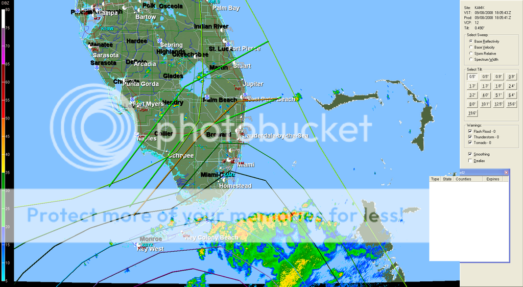
Ike cloud shield says 'knock knock' to florida

Image
0 likes   

User avatar
Lowpressure
S2K Supporter
S2K Supporter
Posts: 2032
Age: 58
Joined: Sun Sep 14, 2003 9:17 am
Location: Charlotte, North Carolina

Re:

#5527 Postby Lowpressure » Mon Sep 08, 2008 1:01 pm

KWT wrote:With regards to strengthen upto landfall, remember a cat-1 strengthening towards a 2, like Dolly actually did and Humberto came close, is quite a different beast to a cat-3/4, which won't strengthen upto landfall because the waters are still fairly shallow.


Agreed, but my point is there is something to be said about conditions being ripe in that area for certain storms at least. I am not suggesting a major does the same, but I would bet that it does not fade like Gustav. Just an observation.
0 likes   

User avatar
Aristotle
Tropical Storm
Tropical Storm
Posts: 141
Age: 59
Joined: Wed Aug 27, 2008 8:16 pm
Location: Crowley, TX

Re: Re:

#5528 Postby Aristotle » Mon Sep 08, 2008 1:02 pm

KWT wrote:
Lowpressure wrote:Here is one good example from the NHC achieves 2007.
Humberto was a short-lived tropical cyclone that made landfall in extreme southeastern Texas as a strong category 1 hurricane (on the Saffir-Simpson Hurricane Scale). The hurricane is notable for its exceptionally rapid intensification near the coast of Texas from a tropical depression into a hurricane within 19 hours.

Dolly this year.


I think what Derek said about the shelf waters near LA also stands for Texas though maybe not quite as much, a 1/2s can strengthen upto landfall, a 3 will hold stead, 4/5s usually weaken.


Actually Lowpressure, What hes said for LA goes especially for Texas. The shelf is much much bigger in front of Tx than it is in front of LA (especially right around NO). So typically Hurricans will weaken or remain the same longer than they would over LA.
0 likes   

Sanibel
Category 5
Category 5
Posts: 10375
Joined: Mon Aug 30, 2004 11:06 pm
Location: Offshore SW Florida

Re: ATL IKE: Category 2 - Discussion

#5529 Postby Sanibel » Mon Sep 08, 2008 1:03 pm

Anybody have a Cuban radar for core progress offshore?
0 likes   

User avatar
vaffie
Category 3
Category 3
Posts: 898
Joined: Sat Sep 11, 2004 5:11 pm
Location: Houston, Texas

Re: Re:

#5530 Postby vaffie » Mon Sep 08, 2008 1:04 pm

Aristotle wrote:Actually Lowpressure, What hes said for LA goes especially for Texas. The shelf is much much bigger in front of Tx than it is in front of LA (especially right around NO). So typically Hurricans will weaken or remain the same longer than they would over LA.


Note that it has a lot to do with speed of movement. A fast moving storm will not weaken as fast. This looks to be fast arrival...
0 likes   

jacindc
Tropical Depression
Tropical Depression
Posts: 79
Joined: Tue Sep 16, 2003 8:38 pm
Location: Capitol Hill, DC

#5531 Postby jacindc » Mon Sep 08, 2008 1:06 pm

Aren't there about six other places where you people could be having this conversation?
0 likes   

User avatar
KWT
Category 5
Category 5
Posts: 31415
Joined: Tue Aug 17, 2004 11:02 am
Location: UK!!!

Re: Re:

#5532 Postby KWT » Mon Sep 08, 2008 1:06 pm

Lowpressure wrote:
Agreed, but my point is there is something to be said about conditions being ripe in that area for certain storms at least. I am not suggesting a major does the same, but I would bet that it does not fade like Gustav. Just an observation.


Well Gustav got hammered by shear as it went over Cuba and then pretty much across the gulf, plus it made the crossing around 36hrs, Ike will have at least double that time even if it does move as fast as some models suggest.

Anyway NHC now have the center at 21.2N so as I thought before there has been some slight north of west motion recently, very slight mind you!
0 likes   

tolakram
Admin
Admin
Posts: 20009
Age: 62
Joined: Sun Aug 27, 2006 8:23 pm
Location: Florence, KY (name is Mark)

Re: ATL IKE: Category 2 - Discussion

#5533 Postby tolakram » Mon Sep 08, 2008 1:07 pm

Image

Image
0 likes   

User avatar
HURAKAN
Professional-Met
Professional-Met
Posts: 46086
Age: 38
Joined: Thu May 20, 2004 4:34 pm
Location: Key West, FL
Contact:

#5534 Postby HURAKAN » Mon Sep 08, 2008 1:07 pm

Image

The convection continues to be shallow.
0 likes   

User avatar
Hurricanewatcher2007
Category 2
Category 2
Posts: 578
Joined: Sat Jul 05, 2008 8:10 pm

Re: ATL IKE: Category 2 - Discussion

#5535 Postby Hurricanewatcher2007 » Mon Sep 08, 2008 1:08 pm

So far Ike appears to be a whole lot weaker then 100mph like the NHC has as its current strength. Highest FL winds are only 57kts with a pressure of about 968mb
0 likes   

jlauderdal
S2K Supporter
S2K Supporter
Posts: 7183
Joined: Wed May 19, 2004 5:46 am
Location: NE Fort Lauderdale
Contact:

Re: ATL IKE: Category 2 - Discussion

#5536 Postby jlauderdal » Mon Sep 08, 2008 1:08 pm

jinftl wrote:Ike cloud shield says 'knock knock' to florida

Image


and its convection shield says


Image
0 likes   

smw1981
S2K Supporter
S2K Supporter
Posts: 253
Joined: Tue Jul 31, 2007 9:04 pm
Location: Alabamer

Re: ATL IKE: Category 2 - Discussion

#5537 Postby smw1981 » Mon Sep 08, 2008 1:09 pm

jinftl wrote:Now Texans are getting a bad rap....never as bad as the one floridians have here in geneal though....and south floridians for sure have a bad connotation although i am not ever sure why...could just the the large number of us.

Who cares where people are from...all that matters is where they are...and that is participating and learning on S2k! PLus -removed- is an equal opportunity hobby....florida folks had there turn, now the GoMers are passed that baton.

smw1981 wrote:
gatorcane wrote:what happened to all of the Florida posters? It's interesting to note that one can quickly parse the active tropics page looking for usernames to quickly see where a storm may be threatening.

In this case I see alot of LA and Texas posters so without even looking at the NHC track, I know where the system may be heading...


I said something about this during Gustav and was told by a Mod that it wasn't their fault that there are more Texas members than MGC, AL, and FL panhandle....

Also, I think (actually know) that people get tired of all of the Texas folks saying "it is coming here". Not that MGC, LA, Alabama and FL people don't say that, there are just more Texans so therefore it gets said over and over and over again. Someone PMed me last night saying this is exactly what happened with Gustav and it didn't even rain in TX...no use sticking around listening (reading) all of that.

Please do not yell at me for saying all of this....like I said, everyone else does it too!


Haha...I don't want ANYONE to have a bad rap! My only point was/is that there are many more posters from Texas (who therefore -rightfully - talk about a Texas threat) than other places (besides S.FL). That means that when there is a storm in the GOM, a lot of the talk is about Texas.... Doesn't necessarily mean it's a bad thing, pretty normal really!

Back to the storm...I think the models will change and the track will change, so there is no reason for people to panic. Maybe get some water, a few batteries, and a loaf of bread and call it a day!

PS - I live almost 300 miles from the coast, so this doesn't affect me! :wink:
0 likes   

clfenwi
Category 5
Category 5
Posts: 3331
Joined: Thu Jun 09, 2005 12:54 pm

Re: ATL IKE: Category 2 - Discussion

#5538 Postby clfenwi » Mon Sep 08, 2008 1:09 pm

Sanibel wrote:Anybody have a Cuban radar for core progress offshore?


http://www.insmet.cu/asp/genesis.asp?TB ... AXw01a.gif

It has been slow... but it has been loading.
0 likes   

Sanibel
Category 5
Category 5
Posts: 10375
Joined: Mon Aug 30, 2004 11:06 pm
Location: Offshore SW Florida

Re: ATL IKE: Category 2 - Discussion

#5539 Postby Sanibel » Mon Sep 08, 2008 1:10 pm

Input:

Lili and Isadore both stumbled after land interaction. If you apply a direct analogy Gus entered a Gulf that didn't support it after crossing Cuba. But it was enough to maintain category 2 into Louisiana. Ike?
0 likes   

jinftl
Category 5
Category 5
Posts: 4312
Joined: Tue Aug 31, 2004 4:47 pm
Location: fort lauderdale, fl

Re: ATL IKE: Category 2 - Discussion

#5540 Postby jinftl » Mon Sep 08, 2008 1:12 pm

where is the plane in relation to the storm? near the eye?


Hurricanewatcher2007 wrote:So far Ike appears to be a whole lot weaker then 100mph like the NHC has as its current strength. Highest FL winds are only 57kts with a pressure of about 968mb
0 likes   


Return to “2008”

Who is online

Users browsing this forum: No registered users and 10 guests