ATL: Tropical Depression Dolly

Moderator: S2k Moderators

Message
Author
Air Force Met
Military Met
Military Met
Posts: 4372
Age: 56
Joined: Tue Jul 08, 2003 9:30 am
Location: Roan Mountain, TN

Re: ATL: TS Dolly in Southern Gulf of Mexico

#5821 Postby Air Force Met » Mon Jul 21, 2008 7:58 pm

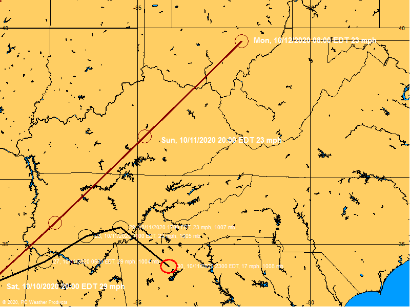
HurricaneRobert wrote:NHC has forecast the track well. Since it moved a little bit north across the Yucatan, this thing hasn't deviated much from the path. It doesn't look like its going way up the coast.


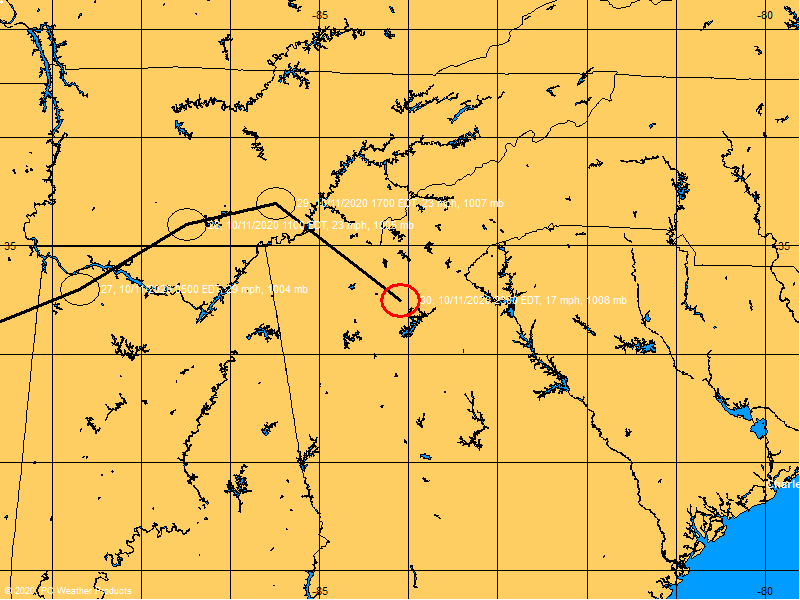
Latest VDM shows the center is 30 miles SW of the current track...and 15 miles SW of the 8PM advisory location.
0 likes   

jeff
Professional-Met
Professional-Met
Posts: 831
Joined: Sun Sep 12, 2004 6:14 pm
Location: Houston, TX
Contact:

Re: Re:

#5822 Postby jeff » Mon Jul 21, 2008 7:59 pm

HarlequinBoy wrote:
jeff wrote:
KWT wrote:jeff do you think there willbe any major Evacs if this system really ramps up in the next 12hrs, or is there not really the time. i hope we don't have a set-up where we have a rapidly strengthening hurricane with people really only having one full day to get prepared.


There is no time...call for evacs and have people stuck on the freeways when the storm moves ashore. If it really ramps up on Tuesday the plan it to clear the barrier islands and shelter inland out of the surge zone. Luckily landfall location is very unpopulated...although to be on the safe side I would leave SPI early Tuesday.


But Corpus and Brownsville are pretty populated. I doubt they should/would evac since they aren't on the coast but they should prepare for strong winds imo.[/quot

Yea.. a lot of people..but they would not evac for a cat 1/2 except barrier islands and low lying areas affected by surge. As far as wind goes...shelter locally in strongest buildings.
0 likes   

Derek Ortt

Re: ATL: TS Dolly in Southern Gulf of Mexico

#5823 Postby Derek Ortt » Mon Jul 21, 2008 7:59 pm

Matt-hurricanewatcher wrote:Even so Dolly has much better convection and outflow, the recon is not finding anything strong. In fact the winds are lower then they where this morning. Hard to believe.


Matt, please stick to the facts

the pressure is lower this morning

besides, today it was only supposed to intensify slowly. It has done so. Tomorrow is the day itis supposed to blow up
0 likes   

cpdaman
Category 5
Category 5
Posts: 3131
Joined: Sat Jun 10, 2006 11:44 am
Location: SPB county (gulf stream)

Re: ATL: TS Dolly in Southern Gulf of Mexico

#5824 Postby cpdaman » Mon Jul 21, 2008 8:01 pm

appears to be slowing down to me in the last two frames, this and the movement west (of yucatan) i would think would help southerly inflow and help consolidate this better by morning. lets see if she sucks in those t-storms SE of the bay of cameche.

btw i still see slightly N of west movement i.e 280 ish
Last edited by cpdaman on Mon Jul 21, 2008 8:03 pm, edited 1 time in total.
0 likes   

Ed Mahmoud

Re: ATL: TS Dolly in Southern Gulf of Mexico

#5825 Postby Ed Mahmoud » Mon Jul 21, 2008 8:01 pm

RL3AO wrote:1913z VDM: 22 46'N, 90 43'W (22.77N, 90.72W)
0023z VDM: 22 59'N, 91 58'W (22.98N, 91.97W)
Vector between two points: 280 @ 13.7 kt


I was calculating about 285º from eyeball on visible loops, so a turn more to the NW everyone was claiming to see doesn't seem to have happened.

Colder than -70ºC, and I think it is trying to wrap a center. No idea how strong it'll get, recon winds don't seem that high yet, but I've noticed sometimes pressure tanks before winds respond.

Image
0 likes   

jeff
Professional-Met
Professional-Met
Posts: 831
Joined: Sun Sep 12, 2004 6:14 pm
Location: Houston, TX
Contact:

Re: ATL: TS Dolly in Southern Gulf of Mexico

#5826 Postby jeff » Mon Jul 21, 2008 8:02 pm

Derek Ortt wrote:
Matt-hurricanewatcher wrote:Even so Dolly has much better convection and outflow, the recon is not finding anything strong. In fact the winds are lower then they where this morning. Hard to believe.


Matt, please stick to the facts

the pressure is lower this morning

besides, today it was only supposed to intensify slowly. It has done so. Tomorrow is the day itis supposed to blow up


Convection this morning was very intense to the NE of the center...that was likely helpingt he stornger winds. With such a large wind field the PGF will take a little time to catch up the the pressure falls... give it a little time folks. Does a thunderstorms go from no cloud to supercell in 1 minute...no the PROCESS takes time.
0 likes   

User avatar
HURAKAN
Professional-Met
Professional-Met
Posts: 46086
Age: 38
Joined: Thu May 20, 2004 4:34 pm
Location: Key West, FL
Contact:

#5827 Postby HURAKAN » Mon Jul 21, 2008 8:03 pm

Image

Image
0 likes   

User avatar
KWT
Category 5
Category 5
Posts: 31415
Joined: Tue Aug 17, 2004 11:02 am
Location: UK!!!

#5828 Postby KWT » Mon Jul 21, 2008 8:03 pm

Exactly Derek its got lower pressures and has clearly organised in terms of convective coverage over the last 6hrs so I think your right we are going to have to wait for the next 6-12hrs before we see this storm relaly get into top gear once the better inflow conditions develop and also the shear finally totally eases off.
0 likes   

Matt-hurricanewatcher

Re: ATL: TS Dolly in Southern Gulf of Mexico

#5829 Postby Matt-hurricanewatcher » Mon Jul 21, 2008 8:03 pm

Derek Ortt wrote:
Matt-hurricanewatcher wrote:Even so Dolly has much better convection and outflow, the recon is not finding anything strong. In fact the winds are lower then they where this morning. Hard to believe.


Matt, please stick to the facts

the pressure is lower this morning

besides, today it was only supposed to intensify slowly. It has done so. Tomorrow is the day itis supposed to blow up


I will try, but it is pretty hard not to post that the recon was finding 50-55 knot flight level winds this morning and only 45 knot winds now. I'm starting to doubt if I have any idea what I'm talking about my self. I think you maybe right. :cry:

I'm having a hard time pulling it together the last few weeks.
Last edited by Matt-hurricanewatcher on Mon Jul 21, 2008 8:04 pm, edited 1 time in total.
0 likes   

RL3AO
Moderator-Pro Met
Moderator-Pro Met
Posts: 16308
Joined: Thu Jun 14, 2007 10:03 pm
Location: NC

#5830 Postby RL3AO » Mon Jul 21, 2008 8:04 pm

Very very primitive stages of an eyewall.
0 likes   

Ed Mahmoud

Re: ATL: TS Dolly in Southern Gulf of Mexico

#5831 Postby Ed Mahmoud » Mon Jul 21, 2008 8:05 pm

Anyone with more sophisticated tools know what the heading would be required from the current center to even landfall in the US? It is certainly more than 280º

Because, unofficially, my expectation that this will landfall South of the Rio Bravo del Norte seems even more likely.

Probably not far enough South to prevent hurricane conditions in BRO and SPI, however, if I had to guess.


Amateur and unofficial guess.
0 likes   

User avatar
KWT
Category 5
Category 5
Posts: 31415
Joined: Tue Aug 17, 2004 11:02 am
Location: UK!!!

#5832 Postby KWT » Mon Jul 21, 2008 8:06 pm

Yeah thats interesting RL3AO theres certainly just a hint of that on the southern side of the center, lets see how it evolves. Also that IR image Ed does look really interesting as well.
0 likes   

Air Force Met
Military Met
Military Met
Posts: 4372
Age: 56
Joined: Tue Jul 08, 2003 9:30 am
Location: Roan Mountain, TN

Re:

#5833 Postby Air Force Met » Mon Jul 21, 2008 8:06 pm

KWT wrote:AFM, will that left hook have any major effect on the longer term track?

Matt, I think we are just going to have to wait for the surface winds to catch up with the deepening of the system in the last few hours.


Its hard to tell if it is just a wobble or a trend. The steering is very complicated since it is moving around the northern end of the TUTT to its south. I think the NHC track is probably a little to far north...and I expect Dolly will move a little west of the current track until it is in the western GoM...then it should hook to the right some...coming in around the Rio Grande.

But...given the complicated steering...and knowing that the models are garbage when trying to forecast what the TUTT will do (they've been spot on so far...right? /sarcasm)...its a tough call.
0 likes   

User avatar
Portastorm
Storm2k Moderator
Storm2k Moderator
Posts: 9914
Age: 63
Joined: Fri Jul 11, 2003 9:16 am
Location: Round Rock, TX
Contact:

Re: Re:

#5834 Postby Portastorm » Mon Jul 21, 2008 8:07 pm

But Corpus and Brownsville are pretty populated. I doubt they should/would evac since they aren't on the coast but they should prepare for strong winds imo.[/quot

Yea.. a lot of people..but they would not evac for a cat 1/2 except barrier islands and low lying areas affected by surge. As far as wind goes...shelter locally in strongest buildings.


There are, unfortunately, hundreds of thousands of Valley residents who live in what are called "colonias." This is essentially sub-standard housing and not up to local codes. Should Dolly be a category 2 at landfall and moving at a decent clip ... and if she moves roughly along the Rio Grande, no one should be surprised when they hear news reports that many thousands of persons will be homeless.
0 likes   

dwg71
Category 5
Category 5
Posts: 2349
Joined: Wed Jun 08, 2005 4:34 pm

#5835 Postby dwg71 » Mon Jul 21, 2008 8:08 pm

I think sticking with my 100 miles south of the border may pay off :)
0 likes   

Matt-hurricanewatcher

Re: ATL: TS Dolly in Southern Gulf of Mexico

#5836 Postby Matt-hurricanewatcher » Mon Jul 21, 2008 8:09 pm

Yeah it doe's appear to be forming more banding like features around its core, maybe even the first signs of a banding eye. We will see. Now I could be totally off base with this.
0 likes   

Air Force Met
Military Met
Military Met
Posts: 4372
Age: 56
Joined: Tue Jul 08, 2003 9:30 am
Location: Roan Mountain, TN

Re: ATL: TS Dolly in Southern Gulf of Mexico

#5837 Postby Air Force Met » Mon Jul 21, 2008 8:09 pm

Ed Mahmoud wrote:Anyone with more sophisticated tools know what the heading would be required from the current center to even landfall in the US? It is certainly more than 280º


It would need to move at 298 from its current location.
0 likes   

User avatar
DESTRUCTION5
Category 5
Category 5
Posts: 4423
Age: 43
Joined: Wed Sep 03, 2003 11:25 am
Location: Stuart, FL

Re: ATL: TS Dolly in Southern Gulf of Mexico

#5838 Postby DESTRUCTION5 » Mon Jul 21, 2008 8:11 pm

Air Force Met wrote:
Ed Mahmoud wrote:Anyone with more sophisticated tools know what the heading would be required from the current center to even landfall in the US? It is certainly more than 280º


It would need to move at 298 from its current location.


THIS IS NO SURPRISE AT ALL TO ME...
0 likes   

User avatar
TampaFl
S2K Supporter
S2K Supporter
Posts: 1904
Age: 67
Joined: Thu Sep 04, 2003 11:23 am
Location: Tampa, FL

Re: ATL: TS Dolly in Southern Gulf of Mexico

#5839 Postby TampaFl » Mon Jul 21, 2008 8:11 pm

8pm (7pmcdt) postion - west of forecast track. Map courtesy BoatUSA.com

Image
0 likes   

User avatar
TampaFl
S2K Supporter
S2K Supporter
Posts: 1904
Age: 67
Joined: Thu Sep 04, 2003 11:23 am
Location: Tampa, FL

Re: ATL: TS Dolly in Southern Gulf of Mexico

#5840 Postby TampaFl » Mon Jul 21, 2008 8:12 pm

8pm (7pmcdt) postion - west of forecast track. Map courtesy BoatUSA.com

Image
0 likes   


Return to “2008”

Who is online

Users browsing this forum: No registered users and 5 guests