ATL: IKE Discussion
Moderator: S2k Moderators

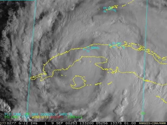
Upper middle keys getting a loooong choochoo train of storms as they pinwheel in from the atlantic....even getting winds and light squalls thru middle of Broward county....250 miles NNE of the eye....gives an idea of the size even when pinned under Cuba and going towards some hilly terrain west of Havana. Speaking of which surprised it didn't try to squeeze thru that flat plain west of Havana...that area has been a magnet for storm tracks in the past.
0 likes

Nor will the people in the densely populated part of south Texas near the border be all that impressed, given they've already taken a sizeable hit from hurricane Dolly just a few short months ago. Frank could you wish this to hit maybe where Bret hit in 1999?
I'm seeing WNW right now in terms of motion, as cycloneye has just said its pretty close to landfall now as well, within the next hour I guess the eye will be onland, shouldn't take long for the eye to cross over Cuba and then the real strengthening can begin again...
I'm seeing WNW right now in terms of motion, as cycloneye has just said its pretty close to landfall now as well, within the next hour I guess the eye will be onland, shouldn't take long for the eye to cross over Cuba and then the real strengthening can begin again...
0 likes
KWT,
Personally, I hope Ike does an Henri (1979) and never makes landfall...
http://en.wikipedia.org/wiki/Image:Henri_1979_track.png
Personally, I hope Ike does an Henri (1979) and never makes landfall...
http://en.wikipedia.org/wiki/Image:Henri_1979_track.png
0 likes
-
Mattie

- S2K Supporter

- Posts: 583
- Joined: Thu Sep 11, 2003 7:44 pm
- Location: North Texas (formerly South Louisiana)
- Contact:
Re: ATL IKE: Category 1 - Discussion
Hasn't it been said that when a 4/5 storm gets in the gulf, they somewhat "make their own path"? If that is correct, this would be a really watch and see event. Will the largeness of Ike prevent him from doing this?
0 likes
Re: ATL IKE: Category 1 - Discussion
carversteve wrote:Is it my eyes or maybe a wobble..but Ike seems to be moving nw instead of wnw..Comments welcomed as i am just loving tracking Ike!!
Looks to me as if the eye is closing up with Ike as the inner core starts to come inland, I'm seeing a WNW motion but it looks like a NW motion as the eye closes.
The main thing is to see what damage Cuba Mark II does to Ike, because after that we've got a good 3 days to watch and see just how powerful Ike can go, I've got a bad feeling its going to rival its early peak strength...
0 likes

-
Sabanic

- Category 2

- Posts: 683
- Age: 66
- Joined: Wed Aug 01, 2007 7:01 am
- Location: Mobile, AL
- Contact:
Re:
Frank2 wrote:KWT,
Personally, I hope Ike does an Henri (1979) and never makes landfall...
http://en.wikipedia.org/wiki/Image:Henri_1979_track.png
I remember that well. Was a bad year here in Mobile, and we were thinking OMG!!
0 likes
Yes, that's rough - the Cuban government has said that the western provinces were already in trouble due to Gustav...
Of course, the situation in Haiti is desparate at this time, and, the Turks & Caicos and even Jamacia isn't much better - a bad season for the western Caribbean, for certain...
Of course, the situation in Haiti is desparate at this time, and, the Turks & Caicos and even Jamacia isn't much better - a bad season for the western Caribbean, for certain...
Last edited by Frank2 on Tue Sep 09, 2008 8:44 am, edited 3 times in total.
0 likes
Yep yet another close hit from Ike Gatorcane and looks like this is only a shade east of where Gustav made landfall as well less then 2 weeks ago, what terrible luck for those in tthat area...
Just be thankful Ike is somewhat weaker though Ike's 70kts winds is something that that area really doesn't need right now.
Just be thankful Ike is somewhat weaker though Ike's 70kts winds is something that that area really doesn't need right now.
0 likes
-
Ed Mahmoud
Re:
Frank2 wrote:hiflyer,
I can see you're a National Airlines alumni - most are asking "What's National Airlines?"
Funny, but, last night I had a dream about Eastern Airlines - not sure why, but, just one those dreams old Floridians have, I guess...
Life in South Florida during hurricane season...
I'm old enough to remember the "I'm (insert female name), Fly Me", which so cheesed off humorless feminists. I flew the Eastern LGA to BOS shuttle once to visit my grandmother.
Back on topic:
GOMEX ridge looks large and in charge, and with three very similar runs in a row of the GFS, I'm a believer.
I may be wrong on the spirit of my "Texas - Season Over?" speculation, as hurricane force winds possible on Padre Island and vicinity, but the ridge axis has stayed well South of its Summer position for several weeks, leaving most of Texas in Autumn like Westerlies aloft.
0 likes
Re:
gatorcane wrote:Ths Isle of Youth is getting slammed yet again.....first Gustav and now Ike
So I guess you could say it's getting old for those folks, eh?
Sorry. I am not in the least trying to diminish the impact of the storm....the semantics of it all just struck me as funny.
BocaGirl
Barbara
0 likes
-
stayawaynow
- Tropical Low

- Posts: 47
- Joined: Mon Aug 25, 2008 10:07 am
- Location: Wellington, FL.
Frank, you only need to see what Fay did on this board to get an idea...
viewtopic.php?f=54&t=102418&start=0
Anyway yeah Ed the high does look strong on the GFS, the ECM looks more likely though it terms of foward speed and its nailed (totally) the track thus far of Ike where the GFS has been flip flop all over the show...
The thing that I do believe is this will be a big powerful beast in the gulf and wouldn't be all that surprising if this makes it upto 4/5 status, even the NHC note thier forecast strength may well too low.
0 likes


-
ConvergenceZone
.gif)
- Category 5

- Posts: 5241
- Joined: Fri Jul 29, 2005 1:40 am
- Location: Northern California
Although I still think this will go into Mexico, it's like others have said on this board, all it takes is a small weakeness OR a small northwest deviation from the track and bam, it's in texas again.... I do remember Derek mentioning this morning and he think we may have hit the end of the model shifts southward. If that's the case, the forecast point may continue to remain on the border for awhile.
0 likes
-
deltadog03

- Professional-Met

- Posts: 3580
- Joined: Tue Jul 05, 2005 6:16 pm
- Location: Macon, GA
Re: ATL IKE: Category 1 - Discussion
Frank, If I were in LA I wouldn't be giving the all clear. Models can be wrong. Look at the spread on the models now....They are starting to spread out.....
0 likes
Who is online
Users browsing this forum: No registered users and 55 guests