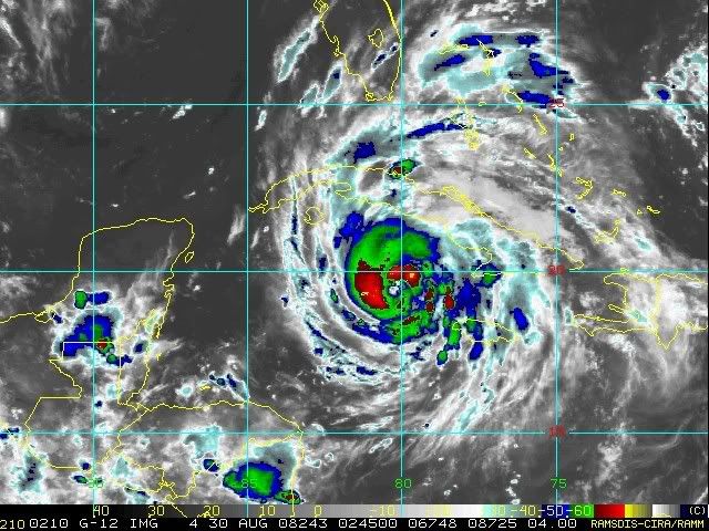
Look at those band stretching into Florida already
I should say its outflow but same difference
ATL GUSTAV: Tropical Depression - Discussion
Moderator: S2k Moderators
-
meteorologyman
- Category 2

- Posts: 541
- Joined: Wed Mar 15, 2006 6:48 pm
- Location: Florida, Kissimmee/St.CLoud
Re: ATL: Hurricane Gustav in NW Caribbean Sea
Last edited by meteorologyman on Fri Aug 29, 2008 10:12 pm, edited 1 time in total.
0 likes
-
Innotech

- Category 5

- Posts: 1031
- Joined: Mon Aug 30, 2004 5:32 pm
- Location: Lafayette, Louisiana
- Contact:
Re: ATL: Hurricane Gustav in NW Caribbean Sea
jdjaguar wrote:Innotech wrote:its looking increasingly likely that I might either experience the eye or very close to it. That probably means tornadoes, screaming winds, and all sorts of other fun. My mom is panicking. My only real concern is at the house I live at on the southside, which is below I10, although its in a reasonably protected neighborhood. The problem is a couple big trees out front. I think theyll be ok but Im packing alot of stuff into my indoor bathroom just to be sure.
I would secure your home and hit the highway.
Sunday at the latest.
good luck and godspeed.
Cant. I have to work on monday. gasoline transport is very important to this region right now. I wont work on Tuesday obviously. I think we will be ok. Wont go outside for the duration of the storm and we have a backup generator, food supplies, and plenty of water and batteries. It will be boring but well be ok.
Actually, if the storm is too close on monday Im not going to work.
I am an assistant and not really required to work. the other dispatchers are going to work up in Little rock on Sunday. I dont like how close the storm is by then. It really depends on the intensity and exact path of it if I go to work or not. Id like to though if it is at all possible.
Last edited by Innotech on Fri Aug 29, 2008 10:14 pm, edited 1 time in total.
0 likes
-
tolakram
- Admin

- Posts: 20183
- Age: 62
- Joined: Sun Aug 27, 2006 8:23 pm
- Location: Florence, KY (name is Mark)
Re: ATL: Hurricane Gustav in NW Caribbean Sea
For those thinking that the track of this storm will slowly be moved west you should take a look at the discussion from one of the pro-mets (student) discussions:
http://nencweather.com/tropicalweather/2008/gustav.html
I'm concerned that people -removed- the models in a certain direction are getting more face time than people who are actually considering what will be happening 2 and 3 days from now. Listen to the NHC and pro-mets and if it's recommended that you evacuate then do so.
0 likes
-
Stormcenter
- S2K Supporter

- Posts: 6689
- Joined: Wed Sep 03, 2003 11:27 am
- Location: Houston, TX
Re:
dwg71 wrote:nhc has not moved their track for three runs now. I would pay great attention if I live in LA, state line to state line. NHC has a central LA landfall in just over 3 days, NHC is pretty good on three day track. Though this forecast may have less confidence.
They probably won't right now even though their track is to far right of the model consensus. I don't think they want anyone in SE La. to become complacent. I also think they want to wait for more model runs. JMHO
0 likes
-
meteorologyman
- Category 2
- Posts: 541
- Joined: Wed Mar 15, 2006 6:48 pm
- Location: Florida, Kissimmee/St.CLoud
Re: ATL: Hurricane Gustav in NW Caribbean Sea
Innotech you must be brave.
however even though Katrina made it to Cat5 strength it made landfall as a Cat3. this storm could be 10 times worse than Katrina, but i'm nat saying it will. if it made landfall as Cat5 I could see ocean water passing I-10
however even though Katrina made it to Cat5 strength it made landfall as a Cat3. this storm could be 10 times worse than Katrina, but i'm nat saying it will. if it made landfall as Cat5 I could see ocean water passing I-10
0 likes
-
Stormcenter
- S2K Supporter
- Posts: 6689
- Joined: Wed Sep 03, 2003 11:27 am
- Location: Houston, TX
Re: ATL: Hurricane Gustav in NW Caribbean Sea
tolakram wrote:For those thinking that the track of this storm will slowly be moved west you should take a look at the discussion from one of the pro-mets (student) discussions:
http://nencweather.com/tropicalweather/2008/gustav.html
I'm concerned that people -removed- the models in a certain direction are getting more face time than people who are actually considering what will be happening 2 and 3 days from now. Listen to the NHC and pro-mets and if it's recommended that you evacuate then do so.
No offense to the Pro Mets or anyone else projecting Gustav's future path but I still recommend sticking with the NHC. As I've said many times before these guys having been doing this for a long time and have tons of experience.
Last edited by Stormcenter on Fri Aug 29, 2008 10:19 pm, edited 1 time in total.
0 likes
Re: ATL: Hurricane Gustav in NW Caribbean Sea
Innotech wrote:jdjaguar wrote:Innotech wrote:its looking increasingly likely that I might either experience the eye or very close to it. That probably means tornadoes, screaming winds, and all sorts of other fun. My mom is panicking. My only real concern is at the house I live at on the southside, which is below I10, although its in a reasonably protected neighborhood. The problem is a couple big trees out front. I think theyll be ok but Im packing alot of stuff into my indoor bathroom just to be sure.
I would secure your home and hit the highway.
Sunday at the latest.
good luck and godspeed.
Cant. I have to work on monday. gasoline transport is very important to this region right now. I wont work on Tuesday obviously. I think we will be ok. Wont go outside for the duration of the storm and we have a backup generator, food supplies, and plenty of water and batteries. It will be boring but well be ok.
understand. prayers are with you and your family. I have been through a few of them myself here in FL.
0 likes
-
Annie Oakley

- Category 5
- Posts: 1103
- Joined: Tue Jul 31, 2007 12:54 pm
- Location: Texas
Re:
HURAKAN wrote:
Wow-another potentially award-winning image of the power of a storm lol. Hurakan-you just keep getting better and better at showing the awesome force of naure.
And I agree-Innotech is very brave indeed.
0 likes
-
Weatherfreak000
Re: ATL: Hurricane Gustav in NW Caribbean Sea
tolakram wrote:For those thinking that the track of this storm will slowly be moved west you should take a look at the discussion from one of the pro-mets (student) discussions:
http://nencweather.com/tropicalweather/2008/gustav.html
I'm concerned that people -removed- the models in a certain direction are getting more face time than people who are actually considering what will be happening 2 and 3 days from now. Listen to the NHC and pro-mets and if it's recommended that you evacuate then do so.
Appreciate the read, thanks.
0 likes
-
tolakram
- Admin
- Posts: 20183
- Age: 62
- Joined: Sun Aug 27, 2006 8:23 pm
- Location: Florence, KY (name is Mark)
Re: ATL: Hurricane Gustav in NW Caribbean Sea
No offense to the Pro Mets or anyone else progecting Gustav's future path but I still recommend sticking with the NHC. As I've said many times before these guys having been doing this for a long time and have tons of experience.
Certainly agree with that, but I also find the discussions offered by meteorologists to be very informative. The NHC is the best there is.
0 likes
Re: ATL: Hurricane Gustav in NW Caribbean Sea
You folks gave me a stroke. I'd stepped away from my computer for a couple of hours and came back to see 888 and 175 mph's. My heart skipped a beat and I went back a page to realize you were discussing Wilma and Gilbert. Geez................Gustav has me somewhat concerned but this was just too much.
0 likes
-
StormWarning1
- Category 1

- Posts: 254
- Joined: Sun Jul 10, 2005 9:29 pm
- Location: Nashville TN
Re: Re:
Stormcenter wrote:dwg71 wrote:nhc has not moved their track for three runs now. I would pay great attention if I live in LA, state line to state line. NHC has a central LA landfall in just over 3 days, NHC is pretty good on three day track. Though this forecast may have less confidence.
They probably won't right now even though their track is to far right of the model consensus. I don't think they want anyone in SE La. to become complacent. I also think they want to wait for more model runs. JMHO
Exactly,
NHC has said they blend meterology with public safety numerous times. Especially on 4/5 day forecast.
If any significant shift to the West is coming on their forecast it will most likely happen on Saturdays 11:00am advisory.
Models have been gradually shifting West over the last three days.
00zGFS about to run, lets see if the trend continues.
0 likes
-
LSU2001

- S2K Supporter
- Posts: 1711
- Age: 58
- Joined: Sat Sep 11, 2004 11:01 pm
- Location: Cut Off, Louisiana
Re: ATL: Hurricane Gustav in NW Caribbean Sea
Ok guys,
I haven't posted yet tonight because I have been boarding up and packing all of the belongings that I cannot afford to lose. If this track is pretty close to being right I fully expect to come home to either nothing left worth salvaging or a well flooded home. I live in Lafourche Parish below the interccoastal waterway and though we have levees they were topped in several places when Rita passed by on her way to Cameron. Areas outside of the levees were torn up pretty bad. I want to comment on the sniping and back and forth banter on this thread.
PLEASE STOP. I understand this is a discussion board and that the nature of it is to discuss possibilities, however for the past 4 years I have looked to S2K as a source of information that is usually ahead of both the NHC and major media outlets. Over the coming days more and more people will be making decisions to protect life and property and the stress level will be out of sight. It helps nothing to try and decipher trends and weather information amid page after page of meaningless comments about who was at fault for the Katrina mess, why the NHC does what it does and why the NOGAPS and UKMET are crackheads.
In all seriousness many people ,including myself, like to use this board as a source of information in addition to official announcements to try and reduce stress and to keep up to date.
Please do not take this post as a bash against anyone or a rant about current rudeness or message board etiquette. It is simply a request to try and stick to relevant information concerning Gustav and what is happening with the storm now. As the weekend progress this will become more and more important.
Thanks,
Tim
0 likes
-
AL Chili Pepper

- Category 3

- Posts: 873
- Joined: Thu Aug 12, 2004 1:15 pm
- Location: Mobile, AL
Re: Re:
bob rulz wrote:How is this still only 80mph?
What is it with storms this year taking so long for the wind speeds to catch up to the pressure?
NHC mentioned concentric wind maxima and light undercutting shear as reasons for slow strengthening at this time, but that once the storm becomes better organized could undergo RI.
Last edited by AL Chili Pepper on Fri Aug 29, 2008 10:26 pm, edited 1 time in total.
0 likes
-
CrazyC83
- Professional-Met

- Posts: 34315
- Joined: Tue Mar 07, 2006 11:57 pm
- Location: Deep South, for the first time!
Re: Re:
bob rulz wrote:HURAKAN wrote:
How is this still only 80mph?
What is it with storms this year taking so long for the wind speeds to catch up to the pressure?
It seems this has a broad pressure gradient, kinda like Katrina and Rita did (although at a much lower intensity in this case).
0 likes
-
hurrican19
- Tropical Storm

- Posts: 153
- Joined: Sun Jun 13, 2004 1:36 pm
- Location: Northwest Austin, TX
(Updated 10:00PM ) Southeast Texas Emergency Management officials have called for an evacuation of Orange, Jefferson and Orange Counties to begin Saturday at 12 p.m. for people with special needs, including people who've called 211 or people who do not have transportation.
They are also asking for a voluntary evacuation starting at noon Saturday.
If the storm continues on its same track or worsens, they will call for a general population evacuation at 6 a.m. Sunday.
http://www.kfdm.com
They are also asking for a voluntary evacuation starting at noon Saturday.
If the storm continues on its same track or worsens, they will call for a general population evacuation at 6 a.m. Sunday.
http://www.kfdm.com
0 likes

-
MGC

- S2K Supporter
- Posts: 5940
- Joined: Sun Mar 23, 2003 9:05 pm
- Location: Pass Christian MS, or what is left.
Re: ATL: Hurricane Gustav in NW Caribbean Sea
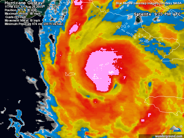
What concerns me tonight besides the possibility of a landfalling major in my neck of the woods is containted in the 11pm discussion. "Data suggests that an outer eyewall with a diameter of 100 N Mi is forming." Yikes! this looks like it is developing into a big hurricane. This will only mean a large surge when Gus makes landfall on the central gulf coast.....MGC
0 likes
-
gtalum

- S2K Supporter
- Posts: 4749
- Age: 50
- Joined: Tue Sep 07, 2004 3:48 pm
- Location: Bradenton, FL
- Contact:
Re: Re:
AL Chili Pepper wrote:How is this still only 80mph?
What is it with storms this year taking so long for the wind speeds to catch up to the pressure?
What's the pressure of the surroundign area? if the whoel area is lower than normal, it could account for lower than expected wind speeds.
0 likes
Who is online
Users browsing this forum: No registered users and 29 guests