


A shift to the east on the latter forecast points.
Moderator: S2k Moderators


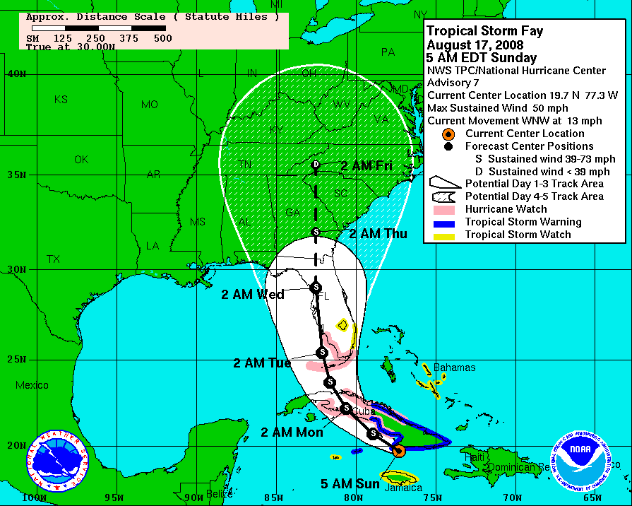
wxwonder12 wrote:Did the NHC change at all the forcast point of entering florida on their 5 day cone map at all?
cpdaman wrote:i think one could look at the loops and see the ULL to the west had a hand in the poor organization/ convectionless left side
http://www.ssd.noaa.gov/goes/east/gmex/loop-wv.html
what's going on with ull is it moving west yet expanding at the same time? is it not that big of a deal, what's the reason for the poor convection (actually there are barely clouds) on the west side?

robbielyn wrote:Ok seems to me with a small hurricane wind field it looks like again tampa will dodge a bullet. the shield remains in place. it will barely be a cat 1 if that. like i said just an inconvenient storm for my area. sorry sanibel a little more serious for you down there.
NDG wrote:I think that area of convection moving away from Jamaica is what robbed some of the southerly inflow to Fay early during the morning, might had been caused by the topography of Jamaica, thus the convection decrease near Fay's LLC besides the high mountainous coastal area in Cuba it encountered earlier in the morning that did not helped it wrap around the moisture.
robbielyn wrote:Ok seems to me with a small hurricane wind field it looks like again tampa will dodge a bullet. the shield remains in place. it will barely be a cat 1 if that. like i said just an inconvenient storm for my area. sorry sanibel a little more serious for you down there.
Terry wrote:robbielyn wrote:Ok seems to me with a small hurricane wind field it looks like again tampa will dodge a bullet. the shield remains in place. it will barely be a cat 1 if that. like i said just an inconvenient storm for my area. sorry sanibel a little more serious for you down there.
You're a bit premature to let your guard down.

AdamFirst wrote:Looks like on the visible satellite that Fay is trying to get her act together...some convection is building near the center
For a storm that has so much opportunity to develop it's certainly not doing so...perhaps we should be thankful
johngaltfla wrote:robbielyn wrote:Ok seems to me with a small hurricane wind field it looks like again tampa will dodge a bullet. the shield remains in place. it will barely be a cat 1 if that. like i said just an inconvenient storm for my area. sorry sanibel a little more serious for you down there.
IF you are wrong and it does ride the ridge up the coastline your neck of the woods will get the worse. Keep in mind the storm had been predicted at many points to head up towards the Big Bend area. I would review my plans at a minimum.
Sanibel wrote:I thought that surface feature was a satellite vortex it looked so weak. If that is the center it has increased in forward speed and is well displaced. This will stay weak for now. Which adds to the problem of underestimating Fay once it gets that ULL to its SW over the Gulf Stream.
Users browsing this forum: No registered users and 87 guests


