ATL GUSTAV: Tropical Depression - Discussion

Moderator: S2k Moderators

Message
Author
6SpeedTA95
Category 5
Category 5
Posts: 1206
Joined: Wed Oct 19, 2005 3:25 pm
Location: Oklahoma
Contact:

Re: Re:

#6301 Postby 6SpeedTA95 » Fri Aug 29, 2008 11:17 pm

thetruesms wrote:
6SpeedTA95 wrote:YES thats correct finally someone who doesn't just look at SST's but TCHP, the entire depth of the warm water makes a difference for slow moving and/or multiple storms!
pfft, what does an Oklahoman know about tropical stuff? :wink: Image 6speed, I finally bit the bullet and quit lurking.

I think another important thing you bring up in your post is how quickly the storms are moving. A plodding Gustav will create a much different scenario for a storm following behind it than a Gustav that is trucking right through.

DUDE how about you get on aim!

Oh and welcome to the board, its good to have another that works for NOAA and is educated in meteorology on the board :) welcome my friend.
Last edited by 6SpeedTA95 on Fri Aug 29, 2008 11:19 pm, edited 1 time in total.
0 likes   

User avatar
Just Joshing You
Category 2
Category 2
Posts: 512
Joined: Sat Nov 03, 2007 10:29 am
Location: Nova Scotia

Re: Re:

#6302 Postby Just Joshing You » Fri Aug 29, 2008 11:18 pm

THead wrote:
AL Chili Pepper wrote:
bob rulz wrote:How is this still only 80mph?

What is it with storms this year taking so long for the wind speeds to catch up to the pressure?


NHC mentioned concentric wind maxima and light undercutting shear as reasons for slow strengthening at this time, but that once the storm becomes better organized could undergo RI.


What is concentric wind maxima? I've seen that a couple of times today, and its a new one on me, haven't heard that phrase before. Thanks.


Best way I can think of to explain this is to use a dartboard analogy.

Image

Think of the location of the doubles and trip rings. Instead of the winds increasing steadily toward the ring around the bullseye...you have wind maxima at both the doubles and trip rings.[/quote]

Thank you!! I was wondering why the winds were so strong at certain areas that shouldn't have been.
0 likes   

User avatar
Innotech
Category 5
Category 5
Posts: 1031
Joined: Mon Aug 30, 2004 5:32 pm
Location: Lafayette, Louisiana
Contact:

Re: ATL: Hurricane Gustav in NW Caribbean Sea

#6303 Postby Innotech » Fri Aug 29, 2008 11:21 pm

crazycajuncane wrote:Haven't posted yet tonight, but here's what's going on around Lafayette.

Good luck finding gas. 8/10 gas stations I passed by on the way home and to a friend of mines were already out of gas. After Sunday it will be nearly impossible to get gasoline. Contraflow is expected Sunday. I put gas on Tuesday, but already down to half a tank.

Local met Rob Perillo seems worried and that is worrying me. We have no plans to go, because we live far enough inland. Plus he was saying if you are planning on leaving to leave the state. Storm may slow down after landfall anywhere.

He also mentioned if the storm goes 10-15 miles west of the current projection we'd see significant storm surge. I keep telling myself the storm is 3 days away and a lot is bound to change.

I live in an apartment and I'm going stay with my parents in a brick home with a generator and lots of stocked food and water. Right now we hope for big changes. We are prepared for the worst, but not knowing what the worst will be really sucks.

Please for those of you who like to talk about your thoughts about what might or might not happen please remember that a lot of people are on here for facts and real information. We have a lot of visitors on the board and LOTS of information going.

Thanks everyone and best wishes to all those in the path!

believe me when I say stores arent out of gas for lack of trying. We really are. Some of them are close to breaking down from all the stress. Its a lot of work and its a losing battle.
0 likes   

O Town
S2K Supporter
S2K Supporter
Posts: 5205
Age: 52
Joined: Wed Sep 07, 2005 9:37 pm
Location: Orlando, Florida 28°35'35"N 81°22'55"W

#6304 Postby O Town » Fri Aug 29, 2008 11:21 pm

Starting to really ramp up.

Image
0 likes   

6SpeedTA95
Category 5
Category 5
Posts: 1206
Joined: Wed Oct 19, 2005 3:25 pm
Location: Oklahoma
Contact:

Re:

#6305 Postby 6SpeedTA95 » Fri Aug 29, 2008 11:22 pm

O Town wrote:Starting to really ramp up.

Image

I does look as if the convection is going to try to envelope the eyewall.
0 likes   

User avatar
Sean in New Orleans
Category 5
Category 5
Posts: 1794
Joined: Thu Aug 28, 2003 7:26 pm
Location: New Orleans, LA 30.0N 90.0W
Contact:

#6306 Postby Sean in New Orleans » Fri Aug 29, 2008 11:22 pm

Based on it's projected path, right now, this system is really destined to do a number on almost the entire Louisiana coastline.
0 likes   

Matt-hurricanewatcher

Re: ATL: Hurricane Gustav in NW Caribbean Sea

#6307 Postby Matt-hurricanewatcher » Fri Aug 29, 2008 11:22 pm

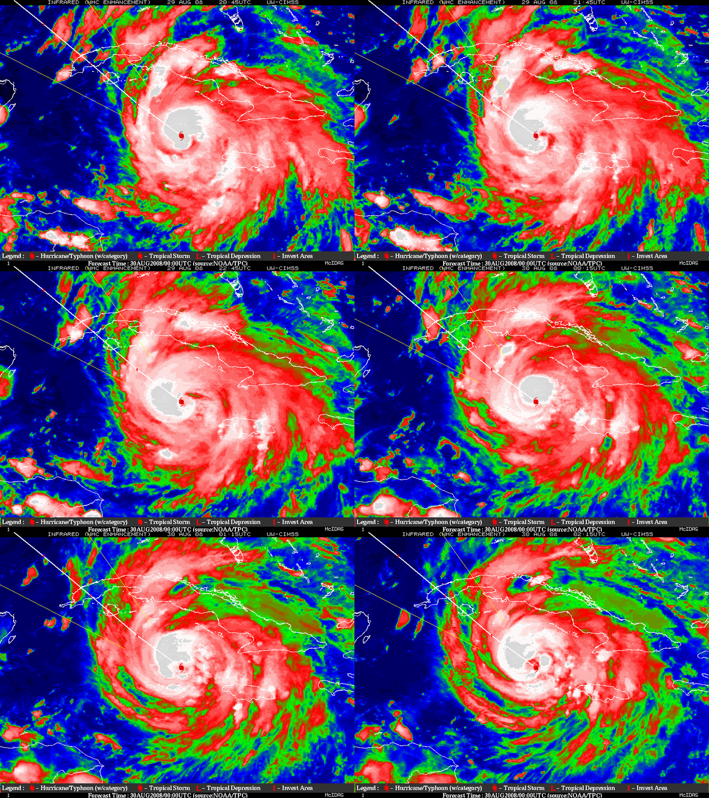
Eye is starting to clear out and reds are wraping around. I believe this system is about ready to "bomb", by bomb I mean 30 millibars in 8 hour time frame is possible if what I think comes true. Also I expect close to 100 knot flight level winds within the next 2 hours to be found.

Image
Last edited by Matt-hurricanewatcher on Fri Aug 29, 2008 11:26 pm, edited 1 time in total.
0 likes   

User avatar
crazycajuncane
S2K Supporter
S2K Supporter
Posts: 1097
Joined: Sun Aug 15, 2004 2:51 pm
Location: Lafayette, Louisiana
Contact:

Re:

#6308 Postby crazycajuncane » Fri Aug 29, 2008 11:24 pm

Sean in New Orleans wrote:Based on it's projected path, right now, this system is really destined to do a number on almost the entire Louisiana coastline.


Not good considering we lose 50 football fields worth of coastline a day isn't it?
0 likes   

User avatar
thetruesms
Professional-Met
Professional-Met
Posts: 844
Age: 41
Joined: Thu Aug 16, 2007 1:14 pm
Location: Tallahasee, FL
Contact:

Re: Re:

#6309 Postby thetruesms » Fri Aug 29, 2008 11:27 pm

crazycajuncane wrote:
Sean in New Orleans wrote:Based on it's projected path, right now, this system is really destined to do a number on almost the entire Louisiana coastline.


Not good considering we lose 50 football fields worth of coastline a day isn't it?
It's fascinating to me to think that powerful storms like this have the potential to literally change the map

edit - I can communicate in English, I swear!
Last edited by thetruesms on Fri Aug 29, 2008 11:28 pm, edited 1 time in total.
0 likes   

6SpeedTA95
Category 5
Category 5
Posts: 1206
Joined: Wed Oct 19, 2005 3:25 pm
Location: Oklahoma
Contact:

Re: Re:

#6310 Postby 6SpeedTA95 » Fri Aug 29, 2008 11:27 pm

crazycajuncane wrote:
Sean in New Orleans wrote:Based on it's projected path, right now, this system is really destined to do a number on almost the entire Louisiana coastline.


Not good considering we lose 50 football fields worth of coastline a day isn't it?

I think thats a year...


And its not good for energy reasons either :(
0 likes   

User avatar
Innotech
Category 5
Category 5
Posts: 1031
Joined: Mon Aug 30, 2004 5:32 pm
Location: Lafayette, Louisiana
Contact:

Re: ATL: Hurricane Gustav in NW Caribbean Sea

#6311 Postby Innotech » Fri Aug 29, 2008 11:30 pm

its going to once again ruin beautiful Grand Isle. Luckily I was able to visit it this year and the beach came back really nicely. It will all be gone again. But it will be back.
0 likes   

User avatar
Just Joshing You
Category 2
Category 2
Posts: 512
Joined: Sat Nov 03, 2007 10:29 am
Location: Nova Scotia

Re: ATL: Hurricane Gustav in NW Caribbean Sea

#6312 Postby Just Joshing You » Fri Aug 29, 2008 11:32 pm

Looking at this storm, I was reminded eerily of Wilma before she went R.I. So I went back into my video footage and lets see what I found.

12:15 UTC OCTOBER 18TH
Image
Image

0:15 UTC OCTOBER 19TH
Image
Image

Compare those to Gustav... the 12:15 UTC with the current Gustav one. Take out the eye and you got the same storm. lol.
0 likes   

User avatar
crazycajuncane
S2K Supporter
S2K Supporter
Posts: 1097
Joined: Sun Aug 15, 2004 2:51 pm
Location: Lafayette, Louisiana
Contact:

Re: Re:

#6313 Postby crazycajuncane » Fri Aug 29, 2008 11:34 pm

6SpeedTA95 wrote:
crazycajuncane wrote:
Sean in New Orleans wrote:Based on it's projected path, right now, this system is really destined to do a number on almost the entire Louisiana coastline.


Not good considering we lose 50 football fields worth of coastline a day isn't it?

I think thats a year...


And its not good for energy reasons either :(


DU biologists say that rate of loss is closer to 48 football fields per day, or one football field every 30 minutes. Louisiana alone loses about 25 square miles of its fertile marsh annually. Unfortunately, that already totals a loss of roughly 1 million acres of the 3.1 million that existed just 100 years ago.

google it. I know it doesn't sound right, but I've seen a commercial about this and read a lot about this.
0 likes   

6SpeedTA95
Category 5
Category 5
Posts: 1206
Joined: Wed Oct 19, 2005 3:25 pm
Location: Oklahoma
Contact:

Re: ATL: Hurricane Gustav in NW Caribbean Sea

#6314 Postby 6SpeedTA95 » Fri Aug 29, 2008 11:35 pm

Just Joshing You wrote:Looking at this storm, I was reminded eerily of Wilma before she went R.I. So I went back into my video footage and lets see what I found.

12:15 UTC OCTOBER 18TH
Image
Image

0:15 UTC OCTOBER 19TH
Image
Image

Compare those to Gustav... the 12:15 UTC with the current Gustav one. Take out the eye and you got the same storm. lol.


No offense but gustav is nowhere near wilma yet. Just look at the intensity of the convection, not even close at this point.
0 likes   

THead
S2K Supporter
S2K Supporter
Posts: 790
Joined: Mon Aug 30, 2004 5:09 pm
Location: Lauderhill, Fla./Jefferson, Ga.

Re: Re:

#6315 Postby THead » Fri Aug 29, 2008 11:36 pm

AJC3 wrote:
THead wrote:
AL Chili Pepper wrote:
NHC mentioned concentric wind maxima and light undercutting shear as reasons for slow strengthening at this time, but that once the storm becomes better organized could undergo RI.


What is concentric wind maxima? I've seen that a couple of times today, and its a new one on me, haven't heard that phrase before. Thanks.


Best way I can think of to explain this is to use a dartboard analogy.

Image

Think of the location of the doubles and trip rings. Instead of the winds increasing steadily toward the ring around the bullseye...you have wind maxima at both the doubles and trip rings.


Cool thanks. Is there an easy explanation as to why that would inhibit strenghtening?
0 likes   

User avatar
Just Joshing You
Category 2
Category 2
Posts: 512
Joined: Sat Nov 03, 2007 10:29 am
Location: Nova Scotia

Re: ATL: Hurricane Gustav in NW Caribbean Sea

#6316 Postby Just Joshing You » Fri Aug 29, 2008 11:37 pm

6SpeedTA95 wrote:
Just Joshing You wrote:Looking at this storm, I was reminded eerily of Wilma before she went R.I. So I went back into my video footage and lets see what I found.

12:15 UTC OCTOBER 18TH
Image
Image

0:15 UTC OCTOBER 19TH
Image
Image

Compare those to Gustav... the 12:15 UTC with the current Gustav one. Take out the eye and you got the same storm. lol.


No offense but gustav is nowhere near wilma yet. Just look at the intensity of the convection, not even close at this point.


I wasn't saying it was Wilma. I was just saying I was eerily reminded of Wilma pre-R.I
0 likes   

User avatar
dixiebreeze
S2K Supporter
S2K Supporter
Posts: 5140
Joined: Wed Sep 03, 2003 5:07 pm
Location: crystal river, fla.

Re: ATL: Hurricane Gustav in NW Caribbean Sea

#6317 Postby dixiebreeze » Fri Aug 29, 2008 11:37 pm

29/2345 UTC 19.1N 80.0W T4.5/4.5 GUSTAV -- Atlantic Ocean
0 likes   

User avatar
Innotech
Category 5
Category 5
Posts: 1031
Joined: Mon Aug 30, 2004 5:32 pm
Location: Lafayette, Louisiana
Contact:

Re: ATL: Hurricane Gustav in NW Caribbean Sea

#6318 Postby Innotech » Fri Aug 29, 2008 11:37 pm

how does it "lose" this acreage? Is it through flooding? I went down to Grand Isle this year as I said before and by the way people talk about Louisianas coastline youd think you could just sit and watch it disappear.
0 likes   

6SpeedTA95
Category 5
Category 5
Posts: 1206
Joined: Wed Oct 19, 2005 3:25 pm
Location: Oklahoma
Contact:

Re: Re:

#6319 Postby 6SpeedTA95 » Fri Aug 29, 2008 11:38 pm

crazycajuncane wrote:
6SpeedTA95 wrote:
crazycajuncane wrote:
And its not good for energy reasons either :(


DU biologists say that rate of loss is closer to 48 football fields per day, or one football field every 30 minutes. Louisiana alone loses about 25 square miles of its fertile marsh annually. Unfortunately, that already totals a loss of roughly 1 million acres of the 3.1 million that existed just 100 years ago.

google it. I know it doesn't sound right, but I've seen a commercial about this and read a lot about this.
Commercial = BS probably by some enviro wacko group.

But if you've read a legit study from a university or someone not tied to the green movement then I could buy it. I've spent a lot of time down there working and its very VERY marshy.
0 likes   

User avatar
Just Joshing You
Category 2
Category 2
Posts: 512
Joined: Sat Nov 03, 2007 10:29 am
Location: Nova Scotia

Re: Re:

#6320 Postby Just Joshing You » Fri Aug 29, 2008 11:39 pm

AJC3 wrote:
THead wrote:
AL Chili Pepper wrote:
NHC mentioned concentric wind maxima and light undercutting shear as reasons for slow strengthening at this time, but that once the storm becomes better organized could undergo RI.


What is concentric wind maxima? I've seen that a couple of times today, and its a new one on me, haven't heard that phrase before. Thanks.


Best way I can think of to explain this is to use a dartboard analogy.

Image

Think of the location of the doubles and trip rings. Instead of the winds increasing steadily toward the ring around the bullseye...you have wind maxima at both the doubles and trip rings.


I'm not a pro met, but I'll take a stab at that.

Maybe because the stronger bands are robbing the center of the storm of the juice needed to intensify, and instead it is just using that juice to keep its outer bands strong?


Cool thanks. Is there an easy explanation as to why that would inhibit strenghtening?[/quote]
0 likes   


Return to “2008”

Who is online

Users browsing this forum: No registered users and 36 guests