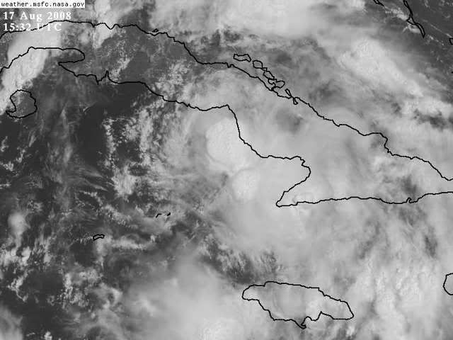
ATL: Tropical Depression Fay

Moderator: S2k Moderators

Message
Author
JPmia
S2K Supporter
S2K Supporter
Posts: 1070
Joined: Thu Jun 03, 2004 11:01 pm
Location: Fort Lauderdale, FL

Re: Re:

#6321 Postby JPmia » Sun Aug 17, 2008 10:35 am

cpdaman wrote:
deltadog03 wrote:Hold on...Go to the 1km SAT. site...I think someone just pulled out the challenge flag...Take a peak down there just west of jamaica....That has what looks like a WELL defined LLC. Turn up the speed a little bid and watch that thing go to town...Theres where most of your inflow is going..


sorry i just don't see it

also fay appears still steady WNW now


neither do i....but it is a nice sat loop though!
0 likes   

User avatar
deltadog03
Professional-Met
Professional-Met
Posts: 3580
Joined: Tue Jul 05, 2005 6:16 pm
Location: Macon, GA

Re: Re:

#6322 Postby deltadog03 » Sun Aug 17, 2008 10:35 am

Steve Cosby wrote:
deltadog03 wrote:Hold on...Go to the 1km SAT. site...I think someone just pulled out the challenge flag...Take a peak down there just west of jamaica....That has what looks like a WELL defined LLC. Turn up the speed a little bid and watch that thing go to town...Theres where most of your inflow is going..


There is certainly activity down there but the low level winds out of it seem to be flowing northeast.

It almost looks like that area is rotating the opposite direction(?)


Thats just great outflow...The ridge is still sitting on top of that.
0 likes   

User avatar
ekal
Tropical Storm
Tropical Storm
Posts: 210
Age: 36
Joined: Thu Aug 25, 2005 11:13 am
Location: Miami, Florida

Re: ATL: Tropical Storm Fay South of Cuba

#6323 Postby ekal » Sun Aug 17, 2008 10:35 am

One burst of convection near the center is not a trend upwards in intensity. Let's see what recon finds and how the satellite presentation continues to evolve, but as of now it looks poor.

UPPER-LEVEL WINDS HAVE
BECOME A LITTLE LESS FAVORABLE FOR DEVELOPMENT THIS MORNING...WITH
THE SHIPS MODEL SHOWING 10 TO 15 KT OF WESTERLY VERTICAL WIND
SHEAR.


That is confirmed using VIS and IR. Much of the convection is occurring in the eastern semicircle.
0 likes   

User avatar
Extremeweatherguy
Category 5
Category 5
Posts: 11095
Joined: Mon Oct 10, 2005 8:13 pm
Location: Florida

#6324 Postby Extremeweatherguy » Sun Aug 17, 2008 10:35 am

I see nothing west of Jamaica either.
0 likes   

User avatar
hurricanefloyd5
Category 5
Category 5
Posts: 1659
Age: 45
Joined: Sun May 02, 2004 10:53 am
Location: Spartanburg
Contact:

Re: ATL: Tropical Storm Fay South of Cuba

#6325 Postby hurricanefloyd5 » Sun Aug 17, 2008 10:36 am

I am not saying i9t will happen but if it wanted to it can pull a Hurricane charlie STRENGTH wise and look where he hit!!!!!!!!!!
0 likes   

cpdaman
Category 5
Category 5
Posts: 3131
Joined: Sat Jun 10, 2006 11:44 am
Location: SPB county (gulf stream)

Re:

#6326 Postby cpdaman » Sun Aug 17, 2008 10:36 am

deltadog03 wrote:Sorry, folks FAY is not looking better. The LLC is beginning to race that blow up of convection...Seriously folks...take a peak at whats next to jamaica..


umm does anyone concur....promets........
0 likes   

Dean4Storms
S2K Supporter
S2K Supporter
Posts: 6358
Age: 62
Joined: Sun Aug 31, 2003 1:01 pm
Location: Miramar Bch. FL

Re:

#6327 Postby Dean4Storms » Sun Aug 17, 2008 10:38 am

deltadog03 wrote:Hold on...Go to the 1km SAT. site...I think someone just pulled out the challenge flag...Take a peak down there just west of jamaica....That has what looks like a WELL defined LLC. Turn up the speed a little bid and watch that thing go to town...Theres where most of your inflow is going..


I don't think so Delta, the LLC is up where the NHC has it and it is very evident.
0 likes   

User avatar
ekal
Tropical Storm
Tropical Storm
Posts: 210
Age: 36
Joined: Thu Aug 25, 2005 11:13 am
Location: Miami, Florida

Re: ATL: Tropical Storm Fay South of Cuba

#6328 Postby ekal » Sun Aug 17, 2008 10:39 am

hurricanefloyd5 wrote:I am not saying i9t will happen but if it wanted to it can pull a Hurricane charlie STRENGTH wise and look where he hit!!!!!!!!!!


This storm is absolutely not going to "pull a Hurricane Charley strength wise." Charley experienced very little land interaction with Cuba and none with Hispaniola. Charley also did not have an LLC that outpaced much of its convection.
0 likes   

User avatar
HURAKAN
Professional-Met
Professional-Met
Posts: 46086
Age: 38
Joined: Thu May 20, 2004 4:34 pm
Location: Key West, FL
Contact:

#6329 Postby HURAKAN » Sun Aug 17, 2008 10:41 am

Image
0 likes   

User avatar
cycloneye
Admin
Admin
Posts: 148496
Age: 69
Joined: Thu Oct 10, 2002 10:54 am
Location: San Juan, Puerto Rico

Re: ATL: Tropical Storm Fay South of Cuba

#6330 Postby cycloneye » Sun Aug 17, 2008 10:41 am

The latest pic at 11:32 AM:

Image
0 likes   

User avatar
deltadog03
Professional-Met
Professional-Met
Posts: 3580
Joined: Tue Jul 05, 2005 6:16 pm
Location: Macon, GA

Re: Re:

#6331 Postby deltadog03 » Sun Aug 17, 2008 10:42 am

Dean4Storms wrote:
deltadog03 wrote:Hold on...Go to the 1km SAT. site...I think someone just pulled out the challenge flag...Take a peak down there just west of jamaica....That has what looks like a WELL defined LLC. Turn up the speed a little bid and watch that thing go to town...Theres where most of your inflow is going..


I don't think so Delta, the LLC is up where the NHC has it and it is very evident.


I know where the LLC..lol I am just saying that was robbing some of the southerly inflow into the system.
0 likes   

jlauderdal
S2K Supporter
S2K Supporter
Posts: 7240
Joined: Wed May 19, 2004 5:46 am
Location: NE Fort Lauderdale
Contact:

Re: ATL: Tropical Storm Fay South of Cuba

#6332 Postby jlauderdal » Sun Aug 17, 2008 10:43 am

ekal wrote:
hurricanefloyd5 wrote:I am not saying i9t will happen but if it wanted to it can pull a Hurricane charlie STRENGTH wise and look where he hit!!!!!!!!!!


This storm is absolutely not going to "pull a Hurricane Charley strength wise." Charley experienced very little land interaction with Cuba and none with Hispaniola. Charley also did not have an LLC that outpaced much of its convection.


you have no clue what it could do tomorrow, im not saying it will bomb out but nhc doesnt know and you dont either
0 likes   

Sanibel
Category 5
Category 5
Posts: 10385
Joined: Mon Aug 30, 2004 11:06 pm
Location: Offshore SW Florida

Re: ATL: Tropical Storm Fay South of Cuba

#6333 Postby Sanibel » Sun Aug 17, 2008 10:44 am

A ULL that shears at 12 knots becomes a ULL that vents at 12 knots once it gets to the SW.
0 likes   

Dean4Storms
S2K Supporter
S2K Supporter
Posts: 6358
Age: 62
Joined: Sun Aug 31, 2003 1:01 pm
Location: Miramar Bch. FL

#6334 Postby Dean4Storms » Sun Aug 17, 2008 10:44 am

I am beginning to think that there was a split that took place as Fay hit the Mountains of DR/Haiti with the mid level circulation riding southward around the island instead of going north around it where it would have also had to go against the ridge whereas the LLC went around the north side and we've seen the two areas of energy ever since leading to the two competing areas of convection.
0 likes   

User avatar
NDG
S2K Supporter
S2K Supporter
Posts: 15507
Joined: Sun Jul 09, 2006 10:14 pm
Location: Orlando, FL

Re: Re:

#6335 Postby NDG » Sun Aug 17, 2008 10:46 am

deltadog03 wrote:
Dean4Storms wrote:
deltadog03 wrote:Hold on...Go to the 1km SAT. site...I think someone just pulled out the challenge flag...Take a peak down there just west of jamaica....That has what looks like a WELL defined LLC. Turn up the speed a little bid and watch that thing go to town...Theres where most of your inflow is going..


I don't think so Delta, the LLC is up where the NHC has it and it is very evident.


I know where the LLC..lol I am just saying that was robbing some of the southerly inflow into the system.


Please admit that is not doing so anymore, :wink:
0 likes   

jlauderdal
S2K Supporter
S2K Supporter
Posts: 7240
Joined: Wed May 19, 2004 5:46 am
Location: NE Fort Lauderdale
Contact:

Re: ATL: Tropical Storm Fay South of Cuba

#6336 Postby jlauderdal » Sun Aug 17, 2008 10:46 am

FYI for Se florida folks, there is some healthy convection offshore heading our way, PWATS are climbing folks
0 likes   

User avatar
deltadog03
Professional-Met
Professional-Met
Posts: 3580
Joined: Tue Jul 05, 2005 6:16 pm
Location: Macon, GA

#6337 Postby deltadog03 » Sun Aug 17, 2008 10:46 am

:uarrow: :uarrow: :uarrow: :uarrow:

Bingo!!!!!
0 likes   

Sanibel
Category 5
Category 5
Posts: 10385
Joined: Mon Aug 30, 2004 11:06 pm
Location: Offshore SW Florida

Re: ATL: Tropical Storm Fay South of Cuba

#6338 Postby Sanibel » Sun Aug 17, 2008 10:47 am

True Dean but this could be a d-min that blasts out with a new burst over 31* SST's. However, it is still too close to land for big action.
0 likes   

User avatar
Emmett_Brown
Category 5
Category 5
Posts: 1433
Joined: Wed Aug 24, 2005 9:10 pm
Location: Sarasota FL

#6339 Postby Emmett_Brown » Sun Aug 17, 2008 10:47 am

Nice little blowup going now just NE of the center. I think we just whitnessed a reorganization, which is still under way. If you zoom out a bit and look at a large sat pic, you can see that the new convection appears to be going almost due W, and should wrap around the center that NHC pegged in the 11am advisory.

Overall structure looks good, inner core structure not yet defined, but getting a little better than 2 hours ago.
0 likes   

User avatar
ekal
Tropical Storm
Tropical Storm
Posts: 210
Age: 36
Joined: Thu Aug 25, 2005 11:13 am
Location: Miami, Florida

Re: ATL: Tropical Storm Fay South of Cuba

#6340 Postby ekal » Sun Aug 17, 2008 10:48 am

jlauderdal wrote:
ekal wrote:
hurricanefloyd5 wrote:I am not saying i9t will happen but if it wanted to it can pull a Hurricane charlie STRENGTH wise and look where he hit!!!!!!!!!!


This storm is absolutely not going to "pull a Hurricane Charley strength wise." Charley experienced very little land interaction with Cuba and none with Hispaniola. Charley also did not have an LLC that outpaced much of its convection.


you have no clue what it could do tomorrow, im not saying it will bomb out but nhc doesnt know and you dont either


A 130-knot cyclone? Look, I can understand if it strengthens into a hurricane. Maybe even 75 knots. But let's be reasonable. Charley had an exceptional UL outflow channel as it phased with the trof to its north. It spent only a few hours over Western Cuba, and it had an inner core when it made landfall in Cuba. This storm has none of those conditions working in favor of it. I think forecasts of a major hurricane at this point are flat-out unnecessary. It would alarm the public.
Last edited by ekal on Sun Aug 17, 2008 10:52 am, edited 2 times in total.
0 likes   


Return to “2008”

Who is online

Users browsing this forum: No registered users and 39 guests