
17:06UTC
Minimum pressure: 990mb
18:45UTC
Minimum pressure: 988mb
20:20UTC
Minimum pressure: 986mb
4mb/3.2h = 1.25mb drop per hour
15 hours from landfall at current rate
18.75 mb drop ~ 967mb ~ 107mpn
ATL: Tropical Depression Dolly
Moderator: S2k Moderators
-
cycloneye

- Admin

- Posts: 149337
- Age: 69
- Joined: Thu Oct 10, 2002 10:54 am
- Location: San Juan, Puerto Rico
Re: ATL: TS Dolly in Western Gulf of Mexico
To let all know CNN has a reporter in the NHC and shortly will tramsmit.Bill Ready will speak.
0 likes

-
weatherguru18
Re: ATL: TS Dolly in Western Gulf of Mexico
Breaking News: CNN Now Says Dolly Is A Hurricane! LOL...anybody esle find that humerous? We knew an hour ago practically.
0 likes

Re: ATL: TS Dolly in Western Gulf of Mexico
cycloneye wrote:To let all know CNN has a reporter in the NHC and shortly will tramsmit.
Thats pretty cool. They had the guy at the SPC during one of the high risk days.
0 likes
-
Wx_Warrior
- Category 5

- Posts: 2718
- Joined: Thu Aug 03, 2006 3:58 pm
- Location: Beaumont, TX
-
cycloneye
- Admin
- Posts: 149337
- Age: 69
- Joined: Thu Oct 10, 2002 10:54 am
- Location: San Juan, Puerto Rico
Re: ATL: TS Dolly in Western Gulf of Mexico
RL3AO wrote:cycloneye wrote:To let all know CNN has a reporter in the NHC and shortly will tramsmit.
Thats pretty cool. They had the guy at the SPC during one of the high risk days.
NHC director Bill Ready will speak.
0 likes
...Dolly becomes a hurricane...the second of the 2008 hurricane
season...
A Hurricane Warning remains in effect for the coast of Texas from
Brownsville to Corpus Christi...and for the northeast coast of
Mexico from Rio San Fernando northward to the border between Mexico
and the United States. Preparations to protect life and property
should be rushed to completion.
A Tropical Storm Warning remains in effect from north of Corpus
Christi to San Luis Pass.
A Tropical Storm Warning and a Hurricane Watch is in effect from La
Pesca to south of Rio San Fernando.
For storm information specific to your area...including possible
inland watches and warnings...please monitor products issued
by your local weather office.
At 400 PM CDT...2100z...the center of Hurricane Dolly was located
near latitude 24.6 north...longitude 95.3 west or about 165 miles...
265 km...east-southeast of Brownsville Texas.
Dolly is moving toward the northwest near 10 mph...17 km/hr.
This motion should bring the core of Dolly near northeastern Mexico
or extreme southern Texas on Wednesday.
Maximum sustained winds have increased to near 75 mph...120
km/hr...with higher gusts. Dolly is a category one hurricane on
the Saffir-Simpson scale. Some strengthening is forecast before
landfall.
Hurricane force winds extend outward up to 15 miles...30 km...from
the center...and tropical storm force winds extend outward up to 160
miles...260 km. Tropical storm force winds should begin to reach
the coasts of northeast Mexico and southern Texas later tonight.
Minimum central pressure reported by a hurricane hunter aircraft was
986 mb...29.12 inches.
Dolly is expected to produce total rain accumulations of 6 to 10
inches...with isolated amounts of 15 inches...over much of south
Texas and northeastern Mexico over the next few days.
Coastal storm surge flooding of 4 to 6 feet above normal tide
levels...along with large and dangerous battering waves...can be
expected near and to the north of where the center makes landfall.
A few tornadoes are possible overnight across the lower and middle
Texas coasts.
Repeating the 400 PM CDT position...24.6 N...95.3 W. Movement
toward...northwest near 10 mph. Maximum sustained winds...75 mph.
Minimum central pressure...986 mb.
An intermediate advisory will be issued by the National Hurricane
Center at 700 PM CDT followed by the next complete advisory at 1000
PM CDT.
$$
Forecaster Avila
0 likes
2100 UTC Tue Jul 22 2008
a Hurricane Warning remains in effect for the coast of Texas from
Brownsville to Corpus Christi...and for the northeast coast of
Mexico from Rio San Fernando northward to the border between Mexico
and the United States. Preparations to protect life and property
should be rushed to completion.
A Tropical Storm Warning remains in effect from north of Corpus
Christi to San Luis Pass.
A Tropical Storm Warning and a Hurricane Watch is in effect from La
Pesca to south of Rio San Fernando.
Hurricane center located near 24.6n 95.3w at 22/2100z
position accurate within 20 nm
present movement toward the northwest or 305 degrees at 9 kt
estimated minimum central pressure 986 mb
Max sustained winds 65 kt with gusts to 80 kt.
64 kt....... 0ne 0se 15sw 0nw.
50 kt....... 50ne 45se 25sw 40nw.
34 kt.......140ne 120se 100sw 120nw.
12 ft seas..200ne 180se 60sw 120nw.
Winds and seas vary greatly in each quadrant. Radii in nautical
miles are the largest radii expected anywhere in that quadrant.
Repeat...center located near 24.6n 95.3w at 22/2100z
at 22/1800z center was located near 24.3n 94.9w
forecast valid 23/0600z 25.3n 96.4w
Max wind 70 kt...gusts 85 kt.
64 kt... 25ne 25se 25sw 25nw.
50 kt... 60ne 60se 45sw 60nw.
34 kt...140ne 120se 100sw 120nw.
Forecast valid 23/1800z 26.0n 97.5w...inland
Max wind 80 kt...gusts 100 kt.
64 kt... 30ne 30se 15sw 0nw.
50 kt... 60ne 60se 30sw 15nw.
34 kt...140ne 120se 100sw 30nw.
Forecast valid 24/0600z 26.0n 99.0w...inland
Max wind 40 kt...gusts 50 kt.
34 kt... 50ne 50se 25sw 25nw.
Forecast valid 24/1800z 26.0n 100.5w...remnant low
Max wind 25 kt...gusts 35 kt.
Forecast valid 25/1800z...dissipated
request for 3 hourly ship reports within 300 miles of 24.6n 95.3w
next advisory at 23/0300z
$$
forecaster Avila
0 likes
-
green eyed girl

- S2K Supporter

- Posts: 46
- Age: 55
- Joined: Fri Sep 07, 2007 11:43 am
- Location: Eden Isles, Slidell
Re:
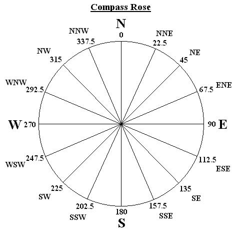
[quote="caribepr"]For those who don't know their compass degrees, here is a very simple compass rose so the numbers used when discussing direction make more sense.
 [/quote
Thank you. That is extremely helpful!
[/quoteThank you. That is extremely helpful!
0 likes

Re: ATL: TS Dolly in Western Gulf of Mexico
drezee wrote:17:06UTC
Minimum pressure: 990mb
18:45UTC
Minimum pressure: 988mb
20:20UTC
Minimum pressure: 986mb
4mb/3.2h = 1.25mb drop per hour
15 hours from landfall at current rate
18.75 mb drop ~ 967mb ~ 107mpn
correction:
NEAR LATITUDE 24.6 NORTH...LONGITUDE 95.3 WEST OR ABOUT 165 MILES...
265 KM...EAST-SOUTHEAST OF BROWNSVILLE TEXAS.
DOLLY IS MOVING TOWARD THE NORTHWEST NEAR 10 MPH...17 KM/HR.
16.5 hours from landfall
20.625 mb drop ~ 965mb ~ 110mph
0 likes
-
raindrops68

- Tropical Low

- Posts: 36
- Joined: Tue Aug 01, 2006 3:28 pm
- Location: Lake Conroe
Re: ATL: TS Dolly in Western Gulf of Mexico
HurricaneHunter914 wrote:raindrops68 wrote:hurricanefloyd5 wrote:Let's pray everyone gose to bed and wake up in the AM to NOT see a cat.2/3 Hurricane!!!!!!!!!!
Im thinking not alot of people are going to be sleeping soundly or maybe even sleeping at all LOL. I know Ill be up late. Love watching hurricane's make landfall.
I don't think she'll be making landfall till tomorrow morning, if she continues this NW movement. I usually wake up at 9:30 so I hope she won't make landfall before then.
Oh yeah it wont be till tomorrow morning but the fun is watching it come closer. Intentions are always good to get to bed for a good night's sleep but it pulls you in and you can't help but watch
0 likes
-
cheezyWXguy

- Category 5
- Posts: 6282
- Joined: Mon Feb 13, 2006 12:29 am
- Location: Dallas, TX
Re: ATL: TS Dolly in Western Gulf of Mexico
drezee wrote:drezee wrote:17:06UTC
Minimum pressure: 990mb
18:45UTC
Minimum pressure: 988mb
20:20UTC
Minimum pressure: 986mb
4mb/3.2h = 1.25mb drop per hour
15 hours from landfall at current rate
18.75 mb drop ~ 967mb ~ 107mpn
correction:
NEAR LATITUDE 24.6 NORTH...LONGITUDE 95.3 WEST OR ABOUT 165 MILES...
265 KM...EAST-SOUTHEAST OF BROWNSVILLE TEXAS.
DOLLY IS MOVING TOWARD THE NORTHWEST NEAR 10 MPH...17 KM/HR.
16.5 hours from landfall
20.625 mb drop ~ 965mb ~ 110mph
Do you all think it will continue to slow down?
0 likes
-
jhamps10
well NHC sees the center right in the middle of it whereas the VDM had it further south. That now makes my earlier distance and direction post null and void.
so on that note it's now 302* to brownsville at 141 miles, Corpus 329* at 221 miles, Kennedy county coastline center, 318* at 185 miles and I will add one more since I said earlier I had my clocking on movement at 310-320degrees based off of brownsville radar, I will put in the spot of 315 degrees from center. that is the Willacy/Kennedy county line. Milage to there right now is 165 miles.
so on that note it's now 302* to brownsville at 141 miles, Corpus 329* at 221 miles, Kennedy county coastline center, 318* at 185 miles and I will add one more since I said earlier I had my clocking on movement at 310-320degrees based off of brownsville radar, I will put in the spot of 315 degrees from center. that is the Willacy/Kennedy county line. Milage to there right now is 165 miles.
0 likes
Dolly is being closely monitored by the NWS radar from
Brownsville...NOAA buoys..satellite and very importantly...by an
Air Force hurricane hunter aircraft. The radar is measuring 75
knots at about 20 thousand feet and show numerous rainbands already
approaching the coasts of northeast Mexico and southern Texas.
Dvorak estimates suggest that Dolly is a hurricane and wind data
just received from the reconnaissance aircraft have confirmed it.
Initial intensity is 65 knots. With the prevailing low
shear...Dolly is forecast to reach the coast a little bit stronger.
Dolly is moving toward the northwest or 305 degrees at 9 knots.
This general track should continue for the next 24 hours with a
small decrease in forward speed. On this track...the core of Dolly
should be near the US/Mexico border within the warning area on
Wednesday. Dolly is large cyclone and tropical storm force winds
will begin to affect the area tonight. After landfall...Dolly
should turn more to west as a subtropical ridge builds to the north
of the cyclone. Most of the track models are in good agreement
bringing the core of Dolly inland in about 24 hours. It should be
re-emphasized that...due to the inherent uncertainties...one must
not focus on the exact landfall point in this forecast.
Due to the slow motion at landfall...Dolly could dump very heavy
rains in the area.
Forecast positions and Max winds
initial 22/2100z 24.6n 95.3w 65 kt
12hr VT 23/0600z 25.3n 96.4w 70 kt
24hr VT 23/1800z 26.0n 97.5w 80 kt...inland
36hr VT 24/0600z 26.0n 99.0w 40 kt...inland
48hr VT 24/1800z 26.0n 100.5w 25 kt...remnant low
72hr VT 25/1800z...dissipated
$$
forecaster Avila
0 likes
Yeah does sound pretty interesting Dreeze, about 15-16hrs til llandfall from the sounds of things, also just in time for Dmax as well...
landfall looks slap bang on the border of Mexico and Texas, Bro. would get hammered if that hpapened by the western eyewall which is pretty explosive in terms of convection right now.
landfall looks slap bang on the border of Mexico and Texas, Bro. would get hammered if that hpapened by the western eyewall which is pretty explosive in terms of convection right now.
0 likes

Re: ATL: H Dolly in Western Gulf of Mexico
Avila is sticking with a high Cat. 1 landfall, but I still believe that a low-mid end Cat. 2 is possible. Radar and satellite presentations must be deceiving, because they surely do not look to show a motion of 305. As Avila states, it is important not to follow the line. Everyone in the cone should pay very close attention.
0 likes
Who is online
Users browsing this forum: No registered users and 19 guests