Not sure what you're looking at...a northerly jog is quite obvious.srainhoutx wrote:Noles2006 wrote:I see no change in track in the last 45-60 minutes... still WNW.
Agreed. WNW continues...
ATL: Tropical Depression Fay
Moderator: S2k Moderators
-
gatorcane

- S2K Supporter

- Posts: 23708
- Age: 48
- Joined: Sun Mar 13, 2005 3:54 pm
- Location: Boca Raton, FL
here is another good shot..
It looks like FAy hits a wall south of Cuba deflecting her more North...very strange....maybe it will knock her out for good I hope:
http://www.ssd.noaa.gov/goes/flt/t1/loop-vis.html
It looks like FAy hits a wall south of Cuba deflecting her more North...very strange....maybe it will knock her out for good I hope:
http://www.ssd.noaa.gov/goes/flt/t1/loop-vis.html
0 likes

-
Shockwave
- Tropical Storm

- Posts: 167
- Joined: Fri Jul 25, 2008 7:33 am
- Location: Lafayette, TN
- Contact:
Re: Re:
deltadog03 wrote:gatorcane wrote:is it me or does it "look" like its starting to jump NNW already now --- probably just an illusion with the mid-level clouds covering the low-level center I guess..
http://www.ssd.noaa.gov/goes/flt/t1/loop-vis.html
Thats the SAT. picture...I noticed the same thing...I was like what....the entire screen/system jumped...bad sat pic or 2...
I saw that too.
 It looks like something caught it and just pushed it back northward, maybe (too me at least) it looked like it made a NE move.
0 likes
-
Ivanhater

- Storm2k Moderator

- Posts: 11221
- Age: 39
- Joined: Fri Jul 01, 2005 8:25 am
- Location: Pensacola
Re: Re:
Jason_B wrote:Not sure what you're looking at...a northerly jog is quite obvious.srainhoutx wrote:Noles2006 wrote:I see no change in track in the last 45-60 minutes... still WNW.
Agreed. WNW continues...
Really? I cant see it...look at the loop, everything jumps "back", bad images in the loop
0 likes


Re: Re:
NEXRAD wrote:KWT wrote:Nexred, problem is the whole thing is getting sheared so not sure you can use the convective movement as a very good guide at the moment IMO.
Agreed - it's tricky, but estimating movement from the LLC alone is prone to wobbles and short-term trends. Matching the two together gives a pretty good sense of where Fay is presently moving. Also, keep watch on the cloud movements ahead of the storm at both surface and upper levels, this helps to reveal the present steering condition setup just ahead of the storm.
- Jay
The last sentence you said Jay is backed up by what you saw with the bands of charlie when it was south of the keys. You predicted that turn before the nhc
0 likes

Careful though because sheared systems are always tough to look using those lower resolution sat imagery, I want to see what recon shows before suggesting there is any wobble to the NW .
This sat loop still suggest a motion close to WNW:
http://hadar.cira.colostate.edu/ramsdis ... ive_0.html
This sat loop still suggest a motion close to WNW:
http://hadar.cira.colostate.edu/ramsdis ... ive_0.html
0 likes
Re: ATL: Tropical Storm Fay South of Cuba
yes that "jump" was a bad satelite shot, the whole atlantic did it lol anyway
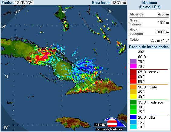
look at the radar folks
http://www.insmet.cu/asp/genesis.asp?TB ... AXw01a.gif
looks better organized as well as back building, keep in mind this has been crippled by land to it's east and north for most of it's life so the center is still gaining "maturity" , perhaps it may set up further E, (and this is not -removed-!) just an observation.
Last edited by cpdaman on Sun Aug 17, 2008 3:06 pm, edited 1 time in total.
0 likes
-
Noles2006

- Category 1

- Posts: 424
- Joined: Thu Jun 08, 2006 9:57 am
- Location: Tallahassee, Florida
- Contact:
Re: Re:
Jason_B wrote:Not sure what you're looking at...a northerly jog is quite obvious.srainhoutx wrote:Noles2006 wrote:I see no change in track in the last 45-60 minutes... still WNW.
Agreed. WNW continues...
http://wwwghcc.msfc.nasa.gov/
1km visible that updates every 5-10 minutes.
0 likes
Re: ATL: Tropical Storm Fay South of Cuba
The 1915Z frame is not aligned properly. There's a massive jump towards the north with every single cloud in the Atlantic according to that frame so the apparent northward "jump" is really partial image error. If this movement is true, then I'd suggest looking towards Antarctica to see what just hit the Earth. 
- Jay
- Jay
0 likes


-
gatorcane
- S2K Supporter
- Posts: 23708
- Age: 48
- Joined: Sun Mar 13, 2005 3:54 pm
- Location: Boca Raton, FL
Re: ATL: Tropical Storm Fay South of Cuba
NEXRAD wrote:The 1915Z frame is not aligned properly. There's a massive jump towards the north with every single cloud in the Atlantic according to that frame so the apparent northward "jump" is really partial image error. If this movement is true, then I'd suggest looking towards Antarctica to see what just hit the Earth.
- Jay
I don't think so.
Look at the Atlantic wide view...I see nothing jumping north but Fay
http://www.ssd.noaa.gov/goes/east/tatl/loop-vis.html
0 likes
-
Ivanhater
- Storm2k Moderator
- Posts: 11221
- Age: 39
- Joined: Fri Jul 01, 2005 8:25 am
- Location: Pensacola
Re: ATL: Tropical Storm Fay South of Cuba
Not seeing any NW movement on radar either..im sure its coming, just not yet
Last edited by Ivanhater on Sun Aug 17, 2008 3:10 pm, edited 1 time in total.
0 likes
-
Frank P
- S2K Supporter
- Posts: 2779
- Joined: Fri Aug 29, 2003 10:52 am
- Location: Biloxi Beach, Ms
- Contact:
Re: ATL: Tropical Storm Fay South of Cuba
Simple to figure out motion in this case... for the time being, as long as it parallels the coast of Cuba its basically moving wnw... that is what the vis sat loops indicate at the moment... my untrained scientific opinion of course
0 likes
-
Extremeweatherguy

- Category 5

- Posts: 11095
- Joined: Mon Oct 10, 2005 8:13 pm
- Location: Florida
-
Noles2006
- Category 1
- Posts: 424
- Joined: Thu Jun 08, 2006 9:57 am
- Location: Tallahassee, Florida
- Contact:
Re: ATL: Tropical Storm Fay South of Cuba
NEXRAD wrote:The 1915Z frame is not aligned properly. There's a massive jump towards the north with every single cloud in the Atlantic according to that frame so the apparent northward "jump" is really partial image error. If this movement is true, then I'd suggest looking towards Antarctica to see what just hit the Earth.
- Jay
LMAO, thank you for posting this... I wanted to say something about it, but I figured it would be obvious to everyone on here that it was an issue with that single satellite frame and not an incredible jump to the North.
0 likes
Who is online
Users browsing this forum: No registered users and 10 guests