ATL: Tropical Depression Fay

Moderator: S2k Moderators

Message
Author
User avatar
Agua
Category 5
Category 5
Posts: 1138
Joined: Thu Jul 31, 2003 4:54 pm
Location: Biloxi, Mississippi

Re:

#6861 Postby Agua » Sun Aug 17, 2008 5:29 pm

RL3AO wrote:URNT12 KNHC 172218
VORTEX DATA MESSAGE AL062008

B. 20 deg 53 min N
080 deg 10 min W


That's too far south.
0 likes   

User avatar
cycloneye
Admin
Admin
Posts: 148496
Age: 69
Joined: Thu Oct 10, 2002 10:54 am
Location: San Juan, Puerto Rico

Re: ATL: Tropical Storm Fay South of Cuba

#6862 Postby cycloneye » Sun Aug 17, 2008 5:30 pm

The last pass is the left one so it has not gained latitud at least in the past 3 hours.

Image
0 likes   

Jason_B

Re: ATL: Tropical Storm Fay South of Cuba

#6863 Postby Jason_B » Sun Aug 17, 2008 5:30 pm

Steve Cosby wrote:
Shockwave wrote:People have been saying that Fay needs to turn NW now for over 5 hours today...but it has yet to do so, so why are we still forecasting a Tampa Bay landfall and not a Pensacola or FL Panhandle landfall?


Because of the trough you can see stretched across the panhandle into the center part of the Gulf of Mexico.
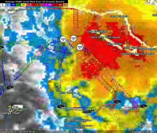
Exactly. The further west it goes is only going to delay the time of a SW/central Florida peninsula landfall, it doesn't necessarily mean the final landfall will be further west.
0 likes   

User avatar
alienstorm
Category 1
Category 1
Posts: 496
Joined: Tue Jul 31, 2007 1:29 pm
Location: Miami Fla western suburb

Re: ATL: Tropical Storm Fay South of Cuba

#6864 Postby alienstorm » Sun Aug 17, 2008 5:31 pm

Cuban radar shows it has slowed down and possibility a jug to the north. We will see if this persist.

http://www.insmet.cu/asp/genesis.asp?TB ... AXw01a.gif
0 likes   

User avatar
HURAKAN
Professional-Met
Professional-Met
Posts: 46086
Age: 38
Joined: Thu May 20, 2004 4:34 pm
Location: Key West, FL
Contact:

#6865 Postby HURAKAN » Sun Aug 17, 2008 5:31 pm

Image

Image
0 likes   

User avatar
KWT
Category 5
Category 5
Posts: 31416
Joined: Tue Aug 17, 2004 11:02 am
Location: UK!!!

#6866 Postby KWT » Sun Aug 17, 2008 5:33 pm

Well recon suggests its south of the NHC track but I don't think the last drop was very good in terms of position so system is probably a little north of where vortex suggests it seems.

Still looking at the Vis.loops looks like Fay is moving about 295 degrees now, solid WNW I think.
0 likes   

MiamiensisWx

#6867 Postby MiamiensisWx » Sun Aug 17, 2008 5:34 pm

When you consider the extremely aggravating nuances involved, the NHC has been doing remarkably well over the past few days in regards to the track.

Kudos to them...
0 likes   

Jason_B

Re: ATL: Tropical Storm Fay South of Cuba

#6868 Postby Jason_B » Sun Aug 17, 2008 5:35 pm

alienstorm wrote:Cuban radar shows it has slowed down and possibility a jug to the north. We will see if this persist.

http://www.insmet.cu/asp/genesis.asp?TB ... AXw01a.gif
Does look like a NNW movement looking at that, that would be right on for the forecast track too so maybe this is a turn starting to unfold.
0 likes   

User avatar
cycloneye
Admin
Admin
Posts: 148496
Age: 69
Joined: Thu Oct 10, 2002 10:54 am
Location: San Juan, Puerto Rico

Re:

#6869 Postby cycloneye » Sun Aug 17, 2008 5:35 pm

MiamiensisWx wrote:When you consider the extremely aggravating nuances involved, the NHC has been doing remarkably well over the past few days in regards to the track.

Kudos to them...


I concur with that.
0 likes   

lbvbl
Tropical Storm
Tropical Storm
Posts: 119
Joined: Fri Aug 15, 2008 8:24 am

Re: ATL: Tropical Storm Fay South of Cuba

#6870 Postby lbvbl » Sun Aug 17, 2008 5:35 pm

shocked to see that broward schools are closed. Palm Beach county schools are in session for tomorrow, but will have a meeting to discuss plans for tuesday. What do you guys think will happen with that. If they have broward schools closed it seems to me theres a good chance of PBC doing the same for tuesday.
0 likes   

tgenius
S2K Supporter
S2K Supporter
Posts: 1160
Joined: Mon May 15, 2006 5:31 pm
Location: Miami, FL

#6871 Postby tgenius » Sun Aug 17, 2008 5:36 pm

I am getting the feeling that the schools closed down a bit prematurely at least on the East Coast. I'm just breathing a sigh of relief as no hurricane warnings=no initiation of BCP plan at work :)
0 likes   

User avatar
SoupBone
Category 5
Category 5
Posts: 3111
Joined: Tue Sep 20, 2005 5:24 pm

Re: ATL: Tropical Storm Fay South of Cuba

#6872 Postby SoupBone » Sun Aug 17, 2008 5:37 pm

Jason_B wrote:
alienstorm wrote:Cuban radar shows it has slowed down and possibility a jug to the north. We will see if this persist.

http://www.insmet.cu/asp/genesis.asp?TB ... AXw01a.gif
Does look like a NNW movement looking at that, that would be right on for the forecast track too so maybe this is a turn starting to unfold.


It has been consistently off the forecast track pretty much the entire day but the slowdown might be an indication of direction changing.
0 likes   

User avatar
HURAKAN
Professional-Met
Professional-Met
Posts: 46086
Age: 38
Joined: Thu May 20, 2004 4:34 pm
Location: Key West, FL
Contact:

#6873 Postby HURAKAN » Sun Aug 17, 2008 5:37 pm

In the case of Miami-Dade, you could have classes but you would expose children to strong gusts and heavy rains found in the squalls that will be moving over the county tomorrow.
0 likes   

User avatar
johngaltfla
Category 5
Category 5
Posts: 2072
Joined: Sun Jul 10, 2005 9:17 pm
Location: Sarasota County, FL
Contact:

Re: ATL: Tropical Storm Fay South of Cuba

#6874 Postby johngaltfla » Sun Aug 17, 2008 5:39 pm

Just another local obs:

Channel 7 here in Sarasota just displayed the VORTEX model and it shows a Sarasota-Manatee County landfall also. So the local mets are still seeing a possible Sarasota County to North Pinellas landfall.

Just a heads up, not a forecast, wishcast or anything official.
0 likes   

Frank P
S2K Supporter
S2K Supporter
Posts: 2779
Joined: Fri Aug 29, 2003 10:52 am
Location: Biloxi Beach, Ms
Contact:

Re: ATL: Tropical Storm Fay South of Cuba

#6875 Postby Frank P » Sun Aug 17, 2008 5:40 pm

Does appear at the moment to be moving closer to the coast now and not parallel... at least from this loop... which is what it needs to do to remain on NHC track..

http://hadar.cira.colostate.edu/ramsdis ... ive_0.html
0 likes   

User avatar
KWT
Category 5
Category 5
Posts: 31416
Joined: Tue Aug 17, 2004 11:02 am
Location: UK!!!

#6876 Postby KWT » Sun Aug 17, 2008 5:42 pm

Yep MiamiensisWx agreed.

I really not sure usibng radar for a sheared system is going to give a very good indication of anything other then maybe a general idea of movement.

Current motion still looks like its WNW I see no real jog yet on the vis imagery though the sun is going down now. Extrap motion takes this just north of Cayman islands IF it doesn't lift any.
0 likes   

Sanibel
Category 5
Category 5
Posts: 10385
Joined: Mon Aug 30, 2004 11:06 pm
Location: Offshore SW Florida

Re: ATL: Tropical Storm Fay South of Cuba

#6877 Postby Sanibel » Sun Aug 17, 2008 5:42 pm

First band through here with light rain. Wind was 5-7 knots from NNW at causeway bridge.

Gray skies and rain to southeast. Upper cirrus outflow band was visible earlier coming from SSE.
0 likes   

User avatar
cheezyWXguy
Category 5
Category 5
Posts: 6240
Joined: Mon Feb 13, 2006 12:29 am
Location: Dallas, TX

Re: ATL: Tropical Storm Fay South of Cuba

#6878 Postby cheezyWXguy » Sun Aug 17, 2008 5:43 pm

Jason_B wrote:
alienstorm wrote:Cuban radar shows it has slowed down and possibility a jug to the north. We will see if this persist.

http://www.insmet.cu/asp/genesis.asp?TB ... AXw01a.gif
Does look like a NNW movement looking at that, that would be right on for the forecast track too so maybe this is a turn starting to unfold.

Thats not the center. The center is further west on the very western edge of the green. It is very hard to see because that is a bad radar with bad location, because the quality is poor, and the center is in the extreme western part of the radar field.
Last edited by cheezyWXguy on Sun Aug 17, 2008 5:44 pm, edited 1 time in total.
0 likes   

lbvbl
Tropical Storm
Tropical Storm
Posts: 119
Joined: Fri Aug 15, 2008 8:24 am

Re:

#6879 Postby lbvbl » Sun Aug 17, 2008 5:44 pm

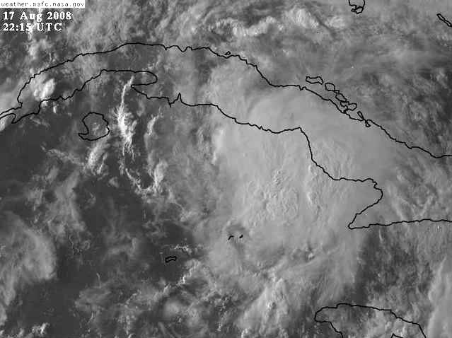
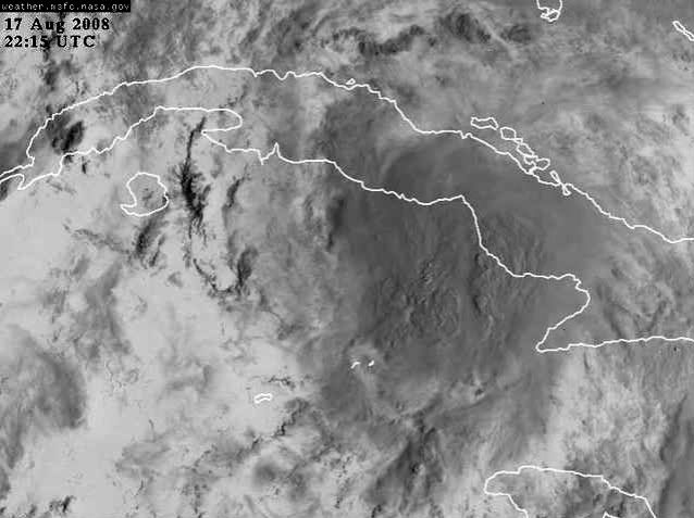
HURAKAN wrote:In the case of Miami-Dade, you could have classes but you would expose children to strong gusts and heavy rains found in the squalls that will be moving over the county tomorrow.


Yeah I can understand the reasoning for Miami-dade... What do you think about PBC schools on tuesday? Depending on the track it takes, the northern part of the county could be affected.
0 likes   

User avatar
DESTRUCTION5
Category 5
Category 5
Posts: 4430
Age: 44
Joined: Wed Sep 03, 2003 11:25 am
Location: Stuart, FL

#6880 Postby DESTRUCTION5 » Sun Aug 17, 2008 5:44 pm

I saw no comment on the 18GFS having Fay just Crawl up the west coast in probably the worst case senerio...
0 likes   


Return to “2008”

Who is online

Users browsing this forum: No registered users and 52 guests