
URNT12 KNHC 172336
VORTEX DATA MESSAGE AL062008
A. 17/23:08:50Z
B. 20 deg 57 min N
080 deg 03 min W
C. 850 mb 1445 m
D. 24 kt
E. 200 deg 32 nm
F. 290 deg 025 kt
G. 201 deg 046 nm
H. 1002 mb
I. 17 C/ 1465 m
J. 19 C/ 1445 m
K. 16 C/ NA
L. NA
M. NA
N. 1345/8
O. 0.02 / 1 nm
P. AF302 1306A FAY OB 20
MAX FL WIND 40 KT SE QUAD 21:53:30 Z
Down a mb.
ATL: Tropical Depression Fay
Moderator: S2k Moderators


-
Matt-hurricanewatcher
Re: ATL: Tropical Storm Fay South of Cuba
It is becoming some what better organized as the core slides under the convection. Better banding on radar to top that off. We will have to see if it can hold on to it and ULL to its west can weaken enough to allow for more organizion. Right now I would go for about 55 knot landfall into Cuba. Maybe not west of 82 as it is looking right now.
Who knows what this is going to do, but it could still become a cane in the gulf.
Who knows what this is going to do, but it could still become a cane in the gulf.
0 likes
-
Emmett_Brown

- Category 5

- Posts: 1433
- Joined: Wed Aug 24, 2005 9:10 pm
- Location: Sarasota FL
Re: Re:
lbvbl wrote:Evil Jeremy wrote:New GFDL is further east than the previous run, showing landfall in Central Florida.
can you show the track, or is there a link you can post?
http://moe.met.fsu.edu/cgi-bin/gfdltc2.cgi?time=2008081712-fay06l&field=Sea+Level+Pressure&hour=Animation
0 likes

Re: ATL: Tropical Storm Fay South of Cuba
sunnyday wrote:I have a question. Why does part of the SE coast of Fl still have a hurricane watch when they've teken this area out of the cone?
just in case. I noticed they have handled all the watches differently this season and I think I like it.
0 likes


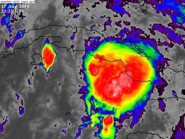

Yep pressure down to 1002mbs, slow strengthening as you'd expect being close to land but the system looks a lot better then it did 6hrs ago, convection really has developed well and at last is over the center, slowly organising now it seems.
big burst over the center as well on that IR.
big burst over the center as well on that IR.
Last edited by KWT on Sun Aug 17, 2008 6:45 pm, edited 1 time in total.
0 likes
Re: ATL: Tropical Storm Fay South of Cuba
Here's another question.. if Fay's windfield is expanding (as it appears to be) wouldn't that mean that TS wind would extend farther east than originally expected?
0 likes
-
Brent
- S2K Supporter

- Posts: 38742
- Age: 37
- Joined: Sun May 16, 2004 10:30 pm
- Location: Tulsa Oklahoma
- Contact:
Re: ATL: Tropical Storm Fay South of Cuba
sunnyday wrote:I have a question. Why does part of the SE coast of Fl still have a hurricane watch when they've teken this area out of the cone?
Remember that a tropical system is not a point. The cone is for the track of the center, not the wide-ranging effects of the storm.
Oh, and it's a TS watch.
Last edited by Brent on Sun Aug 17, 2008 6:45 pm, edited 1 time in total.
0 likes

Re: ATL: Tropical Storm Fay South of Cuba
Thanks for the info. I just dont see a need in a watch when we're not even in the cone. I'm afraid people will be skeptical the next time a storm is out there.
0 likes
-
Over my head

- Tropical Depression

- Posts: 86
- Joined: Sat Aug 18, 2007 7:52 pm
- Location: Southeast Texas
Re:
HURAKAN wrote:
A - B: 88 miles
C - D: 26 miles
It makes a difference.
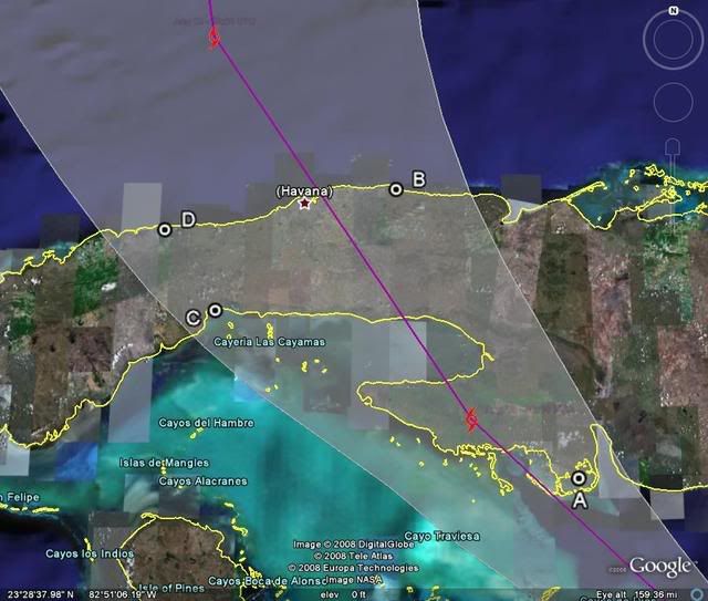
Yes it obviously does. I see how each mile she sneaks further west could make a huge difference now in over water time and intensification possibilities. Boy that image helps a bunch HURAKAN. Thank you.
0 likes
Re: ATL: Tropical Storm Fay South of Cuba
sunnyday wrote:Thanks for the info. I just dont see a need in a watch when we're not even in the cone. I'm afraid people will be skeptical the next time a storm is out there.
the cone shifts, (could shift west again or back right) and there is lots of uncertainty with the track, really pretty straight forward
0 likes
-
caneman
Re: ATL: Tropical Storm Fay South of Cuba
Big slow down. Direction change should follow soon.
0 likes
-
Emmett_Brown
- Category 5
- Posts: 1433
- Joined: Wed Aug 24, 2005 9:10 pm
- Location: Sarasota FL
Re: ATL: Tropical Storm Fay South of Cuba
sunnyday wrote:Thanks for the info. I just dont see a need in a watch when we're not even in the cone. I'm afraid people will be skeptical the next time a storm is out there.
This is probably a better graphic than the cone to give people an idea of the swath that is potentially affected by TS conditions:
[img]http://www.nhc.noaa.gov/refresh/graphics_at1+shtml/205301.shtml?tswind120#contents[/img]
0 likes
Re: ATL: Tropical Storm Fay South of Cuba
Check out this drop
21212 00002 05023
1002mb but with a 23 kt wind.
21212 00002 05023
1002mb but with a 23 kt wind.
0 likes
-
Sabanic

- Category 2

- Posts: 683
- Age: 66
- Joined: Wed Aug 01, 2007 7:01 am
- Location: Mobile, AL
- Contact:
Re: ATL: Tropical Storm Fay South of Cuba
caneman wrote:Big slow down. Direction change should follow soon.
Because it has slowed? Maybe . . . .
0 likes
Who is online
Users browsing this forum: No registered users and 131 guests