ATL: IKE Discussion

Moderator: S2k Moderators

Message
Author
User avatar
Pebbles
S2K Supporter
S2K Supporter
Posts: 1994
Joined: Tue Jul 08, 2003 1:42 pm
Location: New Lenox, IL (SW of Chicago)

Re: ATL IKE: Category 1 - Discussion

#7101 Postby Pebbles » Wed Sep 10, 2008 1:22 am

Hurricanewatcher2007 wrote:Now recon might be finding evidence of a double wind maxima or it could just be that they are flying through an area of lighter convection at the moment. It will be interesting to see what the VDM says about a possible Eye wall replacement cycle!


VDM say eliptical eye.. and this radar pretty much concures with that. I'm not one to jump on the ERC bandwagon as often as others.. but these radar images are making me think it's a possiblity? I want to watch it a bit more before deciding in my own mind only because it really hasn't been off cuba that long...
http://www.met.inf.cu/Radar/00Pinar%20d ... AXw01a.gif

Edit: the only reason I'm hesitating on the ERC theory is because if that IS an outer eyewall, it's broken and still recovering from cuba.. honestly it's late and I just can't make heads or tails of it.
Last edited by Pebbles on Wed Sep 10, 2008 1:26 am, edited 1 time in total.
0 likes   

bob rulz
Category 5
Category 5
Posts: 1704
Age: 35
Joined: Sat Jan 28, 2006 7:30 pm
Location: Salt Lake City, Utah

#7102 Postby bob rulz » Wed Sep 10, 2008 1:24 am

ERC right now in my eyes is a bad thing. It's almost like it's just trying to get it out of the way so that nothing stands in its way to intensify.
0 likes   

Nexus
Tropical Storm
Tropical Storm
Posts: 137
Joined: Sat Sep 11, 2004 12:13 am

#7103 Postby Nexus » Wed Sep 10, 2008 1:24 am

Here is a 5:40 UTC image, losing IR eye feature, but gaining a ton of convection:

http://i456.photobucket.com/albums/qq28 ... 100540.gif
0 likes   

User avatar
Jevo
S2K Supporter
S2K Supporter
Posts: 1729
Age: 47
Joined: Tue Aug 03, 2004 8:45 pm
Location: The Flemish Cap
Contact:

Re: ATL IKE: Category 1 - Discussion

#7104 Postby Jevo » Wed Sep 10, 2008 1:26 am

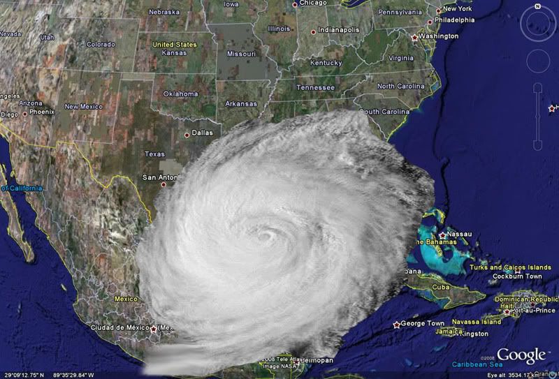
For those wondering.. Here is what Super Typhoon Tip would look like if its eye were positioned in ther central gulf to scale. Even that is the mail core of the system, not the hundreds of miles more of outflow

Image
0 likes   

njweather
Tropical Storm
Tropical Storm
Posts: 169
Joined: Fri Aug 17, 2007 10:45 pm
Location: Washington, DC

Re: ATL IKE: Category 1 - Discussion

#7105 Postby njweather » Wed Sep 10, 2008 1:28 am

Hah, awesome image, Jevo...

Anyways, from the latest VDM:

M. E30/20/10


I know that refers to the eye, but what do three values mean?
0 likes   

Nexus
Tropical Storm
Tropical Storm
Posts: 137
Joined: Sat Sep 11, 2004 12:13 am

#7106 Postby Nexus » Wed Sep 10, 2008 1:29 am

06:05Z VDM pressure 964, down from 968 at 03:16Z
0 likes   

fasterdisaster
Category 5
Category 5
Posts: 1868
Joined: Mon Sep 19, 2005 4:41 pm
Location: Miami, Florida

Re: ATL IKE: Category 1 - Discussion

#7107 Postby fasterdisaster » Wed Sep 10, 2008 1:30 am

njweather wrote:Hah, awesome image, Jevo...

Anyways, from the latest VDM:

M. E30/20/10


I know that refers to the eye, but what do three values mean?


I think it means he has triple eyewalls? Not sure, but this would be only the second time in recorded tropical history a cyclone's had triple eyewalls (Hurricane Juliette of I think 2004 did it in EPAC)
0 likes   

User avatar
Pebbles
S2K Supporter
S2K Supporter
Posts: 1994
Joined: Tue Jul 08, 2003 1:42 pm
Location: New Lenox, IL (SW of Chicago)

#7108 Postby Pebbles » Wed Sep 10, 2008 1:34 am

No there is an E in front of it.. it's eliptical measurements ... means the eye is not circular
0 likes   

User avatar
Hurricanewatcher2007
Category 2
Category 2
Posts: 578
Joined: Sat Jul 05, 2008 8:10 pm

Re: ATL IKE: Category 1 - Discussion

#7109 Postby Hurricanewatcher2007 » Wed Sep 10, 2008 1:35 am

It means the eye is elliptical or another words Oval shaped.

Product: Air Force Vortex Message (URNT12 KNHC)
Transmitted: 10th day of the month at 06:05Z
Aircraft: Air Force Aircraft (Last 3 digits of the tail number are 304)
Storm Number & Year: 09L in 2008
Storm Name: Ike (in the North Atlantic basin)
Mission Number: 17
Observation Number: 05
A. Time of Center Fix: 10th day of the month at 5:53:10Z
B. Center Fix Coordinates: 23°18'N 84°36'W (23.3N 84.6W)
B. Center Fix Location: 141 miles (227 km) to the W (275°) from Havana, Cuba.
C. Minimum Height at Standard Level: 2,797m (9,177ft) at 700mb
D. Estimated (by SFMR or visually) Maximum Surface Wind: 64kts (~ 73.6mph)
E. Location of the Estimated Maximum Surface Wind: 5 nautical miles (6 statute miles) to the NW (312°) of center fix
F. Maximum Flight Level Wind Inbound: From 34° at 66kts (From the NE at ~ 76.0mph)
G. Location of Maximum Flight Level Wind Inbound: 72 nautical miles (83 statute miles) to the NW (305°) of center fix
H. Minimum Sea Level Pressure: 964mb (28.47 inHg)
I. Maximum Flight Level Temp & Pressure Altitude Outside Eye: 11°C (52°F) at a pressure alt. of 3,049m (10,003ft)
J. Maximum Flight Level Temp & Pressure Altitude Inside Eye: 14°C (57°F) at a pressure alt. of 3,049m (10,003ft)
K. Dewpoint Temp (collected at same location as temp inside eye): 14°C (57°F)
K. Sea Surface Temp (collected at same location as temp inside eye): Not Available
L. Eye Character: Open in the southwest
M. Eye Shape: Elliptical (oval shaped)
M. Orientation of Major Axis in Elliptical Eye: 300° to 120° (WNW to ESE)
M. Length of Major Axis in Elliptical Eye: 20 nautical miles
M. Length of Minor Axis in Elliptical Eye: 10 nautical miles
N. Fix Determined By: Penetration, Radar, Wind, Pressure and Temperature
N. Fix Level: 700mb
O. Navigation Fix Accuracy: 0.02 nautical miles
O. Meteorological Accuracy: 3 nautical miles
Remarks Section - Remarks That Were Decoded...
Maximum Flight Level Wind: 66kts (~ 76.0mph) in the northwest quadrant at 5:32:10Z
Radar Presentation: Good
Remarks Section - Additional Remarks...
HEAVIEST CONVECTION NE SIDE. WIND CENTER LESS THAN 3NM IN DIAMETER
0 likes   

User avatar
Hurricanewatcher2007
Category 2
Category 2
Posts: 578
Joined: Sat Jul 05, 2008 8:10 pm

Re: ATL IKE: Category 1 - Discussion

#7110 Postby Hurricanewatcher2007 » Wed Sep 10, 2008 1:37 am

Recon is setting up a pass from Northeast to Southwest. On the VDM it said the heaviest convection was located in the Northeast quad so we will soon find out what the true strength of Ike is at this time!
0 likes   

fasterdisaster
Category 5
Category 5
Posts: 1868
Joined: Mon Sep 19, 2005 4:41 pm
Location: Miami, Florida

#7111 Postby fasterdisaster » Wed Sep 10, 2008 1:39 am

81 kt FL!
0 likes   

User avatar
Hurricanewatcher2007
Category 2
Category 2
Posts: 578
Joined: Sat Jul 05, 2008 8:10 pm

Re: ATL IKE: Category 1 - Discussion

#7112 Postby Hurricanewatcher2007 » Wed Sep 10, 2008 1:41 am

and thats not even near the center. So either Ike is poorly organized with the strongest winds well away from the center or they will find stronger winds then 81kts near the center.
0 likes   

Matt-hurricanewatcher

Re: ATL IKE: Category 1 - Discussion

#7113 Postby Matt-hurricanewatcher » Wed Sep 10, 2008 1:43 am

Jevo wrote:For those wondering.. Here is what Super Typhoon Tip would look like if its eye were positioned in ther central gulf to scale. Even that is the mail core of the system, not the hundreds of miles more of outflow

Image


Now that is what I call impressive...

81 knots at 700 mililbars=72.9 knots at the surface...So pretty much supporting the current strength.
0 likes   

superfly

Re: ATL IKE: Category 1 - Discussion

#7114 Postby superfly » Wed Sep 10, 2008 1:43 am

Hurricanewatcher2007 wrote:and thats not even near the center. So either Ike is poorly organized with the strongest winds well away from the center or they will find stronger winds then 81kts near the center.


That was found in the outer eyewall.
0 likes   

User avatar
Texashawk
Category 2
Category 2
Posts: 579
Joined: Tue Aug 14, 2007 1:50 am
Location: Missouri City, TX (Houston)

Re: ATL IKE: Category 1 - Discussion

#7115 Postby Texashawk » Wed Sep 10, 2008 1:43 am

Hurricanewatcher2007 wrote:and thats not even near the center. So either Ike is poorly organized with the strongest winds well away from the center or they will find stronger winds then 81kts near the center.


Somehow I doubt Ike is poorly organized. :wink:
0 likes   

User avatar
Hurricanewatcher2007
Category 2
Category 2
Posts: 578
Joined: Sat Jul 05, 2008 8:10 pm

Re: ATL IKE: Category 1 - Discussion

#7116 Postby Hurricanewatcher2007 » Wed Sep 10, 2008 1:45 am

superfly wrote:
Hurricanewatcher2007 wrote:and thats not even near the center. So either Ike is poorly organized with the strongest winds well away from the center or they will find stronger winds then 81kts near the center.


That was found in the outer eyewall.


According to the latest VDM there is NO outer eye-wall. they found a Oval shaped eye but thats in no mean indicating a outer eye-wall or anything!
0 likes   

Nexus
Tropical Storm
Tropical Storm
Posts: 137
Joined: Sat Sep 11, 2004 12:13 am

#7117 Postby Nexus » Wed Sep 10, 2008 1:47 am

Newest image 06:09 UTC

Image

Looks like they're listing images from the GOES 13 Sat for tonight's eclipse, normally they don't do that, perhaps because it wasn't possible before tonight, not sure. Low Res, but I'll take it.

http://rammb.cira.colostate.edu/product ... r=AL092008
Last edited by Nexus on Wed Sep 10, 2008 2:06 am, edited 3 times in total.
0 likes   

superfly

Re: ATL IKE: Category 1 - Discussion

#7118 Postby superfly » Wed Sep 10, 2008 1:48 am

Hurricanewatcher2007 wrote:According to the latest VDM there is NO outer eye-wall. they found a Oval shaped eye but thats in no mean indicating a outer eye-wall or anything!


It's in the outer wind maxima, whatever you want to call it. It's obvious from recon.

055430 2315N 08431W 6967 02854 9668 +133 +080 222042 047 055 000 00
055500 2314N 08430W 6971 02875 9699 +129 +080 226060 065 064 000 03
055530 2312N 08429W 6967 02900 9728 +124 +080 226065 065 066 000 00

055600 2311N 08427W 6960 02924 9752 +121 +080 227062 064 065 000 00
055630 2310N 08426W 6967 02937 9773 +117 +080 228061 062 061 000 00
055700 2309N 08425W 6964 02947 9800 +106 +080 230058 059 056 000 00
055730 2307N 08423W 6968 02958 9805 +111 +080 226053 054 054 000 00
055800 2306N 08422W 6965 02970 9813 +112 +080 226052 052 052 000 00
055830 2305N 08421W 6968 02968 9820 +112 +080 224049 051 051 000 00
055900 2304N 08419W 6968 02976 9829 +110 +080 221046 047 050 000 00
055930 2303N 08418W 6964 02988 9836 +109 +080 221045 046 049 000 00
060000 2301N 08417W 6967 02988 9839 +112 +080 221046 047 051 000 00
060030 2300N 08416W 6967 02989 9841 +113 +080 221046 047 052 000 00
060100 2259N 08414W 6968 02993 9844 +113 +080 221045 045 052 000 00
062130 2340N 08340W 6967 03043 9929 +088 +080 160056 057 058 009 00
062200 2342N 08340W 6966 03041 9931 +085 +080 162059 061 059 013 00
062230 2344N 08340W 6967 03040 9932 +085 +080 164062 064 059 012 00
062300 2347N 08340W 6965 03043 9944 +077 +077 165070 072 063 013 00
062330 2349N 08340W 6969 03047 9950 +075 +075 160076 079 063 013 00
062400 2351N 08340W 6971 03039 9945 +080 +080 156078 081 062 009 00
0 likes   

User avatar
Hurricanewatcher2007
Category 2
Category 2
Posts: 578
Joined: Sat Jul 05, 2008 8:10 pm

Re: ATL IKE: Category 1 - Discussion

#7119 Postby Hurricanewatcher2007 » Wed Sep 10, 2008 1:51 am

superfly wrote:
Hurricanewatcher2007 wrote:According to the latest VDM there is NO outer eye-wall. they found a Oval shaped eye but thats in no mean indicating a outer eye-wall or anything!


It's in the outer wind maxima, whatever you want to call it. It's obvious from recon.

055430 2315N 08431W 6967 02854 9668 +133 +080 222042 047 055 000 00
055500 2314N 08430W 6971 02875 9699 +129 +080 226060 065 064 000 03
055530 2312N 08429W 6967 02900 9728 +124 +080 226065 065 066 000 00

055600 2311N 08427W 6960 02924 9752 +121 +080 227062 064 065 000 00
055630 2310N 08426W 6967 02937 9773 +117 +080 228061 062 061 000 00
055700 2309N 08425W 6964 02947 9800 +106 +080 230058 059 056 000 00
055730 2307N 08423W 6968 02958 9805 +111 +080 226053 054 054 000 00
055800 2306N 08422W 6965 02970 9813 +112 +080 226052 052 052 000 00
055830 2305N 08421W 6968 02968 9820 +112 +080 224049 051 051 000 00
055900 2304N 08419W 6968 02976 9829 +110 +080 221046 047 050 000 00
055930 2303N 08418W 6964 02988 9836 +109 +080 221045 046 049 000 00
060000 2301N 08417W 6967 02988 9839 +112 +080 221046 047 051 000 00
060030 2300N 08416W 6967 02989 9841 +113 +080 221046 047 052 000 00
060100 2259N 08414W 6968 02993 9844 +113 +080 221045 045 052 000 00
062130 2340N 08340W 6967 03043 9929 +088 +080 160056 057 058 009 00
062200 2342N 08340W 6966 03041 9931 +085 +080 162059 061 059 013 00
062230 2344N 08340W 6967 03040 9932 +085 +080 164062 064 059 012 00
062300 2347N 08340W 6965 03043 9944 +077 +077 165070 072 063 013 00
062330 2349N 08340W 6969 03047 9950 +075 +075 160076 079 063 013 00
062400 2351N 08340W 6971 03039 9945 +080 +080 156078 081 062 009 00


we will just wait and see what the next VDM says. if there is an outer eye-wall Recon will mention it in the VDM. Its possible that theres just stronger convection on the eastern half of the storm creating the higher winds.
0 likes   

superfly

Re: ATL IKE: Category 1 - Discussion

#7120 Postby superfly » Wed Sep 10, 2008 1:54 am

VDM does not always report concentric eyewalls. You don't need it to see that there are clearly two wind maximas.
0 likes   


Return to “2008”

Who is online

Users browsing this forum: No registered users and 3 guests