ATL: Tropical Depression Dolly
Moderator: S2k Moderators
- HouTXmetro
- Category 5

- Posts: 3949
- Joined: Sun Jun 13, 2004 6:00 pm
- Location: District of Columbia, USA
Re: ATL: H Dolly in Western Gulf of Mexico
americanrebel wrote:HarlequinBoy wrote:americanrebel wrote:I wouldn't be suprised, in fact I wouldn't be surprised if it made it up to Galveston Bay.
It's already west of Galveston Bay.
If you know Hurricanes, a lot of times hurricanes make a jog to the East before making landfall.
Again, Galveston is not in the cone. If that happened the entire NHC staff would be fired. (well maybe not) FEMA flashback
OH OH, pinhole eye on satellite!
Last edited by HouTXmetro on Wed Jul 23, 2008 5:31 am, edited 1 time in total.
0 likes
-
Matt-hurricanewatcher
Re: ATL: H Dolly in Western Gulf of Mexico
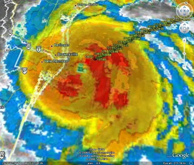
I will guest 965 millibar pressure with this recon, with 83 knot flight level winds.
The reason I believe that it did not have strong winds the last recon was because of it was expanding. Now it is letting loose, but it is running out of time.
I will also guest that this will be 95 knots with 958 millibars at landfall. Now that is a guest in this storm could bit me again.
The reason I believe that it did not have strong winds the last recon was because of it was expanding. Now it is letting loose, but it is running out of time.
I will also guest that this will be 95 knots with 958 millibars at landfall. Now that is a guest in this storm could bit me again.
0 likes
Yeahs thats true Hurakan and the further north it gets the longer it will have over water anyway but depsite that it is true its starting to run low on real estate so tospeak.
Still as we've seen before these systems that are bursting and got deep convection tend to carry on developing right upto landfall.
As for the eye I wonder if land friction is actually helping it to tighten and contract the eye?
Still as we've seen before these systems that are bursting and got deep convection tend to carry on developing right upto landfall.
As for the eye I wonder if land friction is actually helping it to tighten and contract the eye?
0 likes
-
paintplaye
- Category 1

- Posts: 380
- Joined: Sun Jul 20, 2008 11:25 pm
Re: ATL: H Dolly in Western Gulf of Mexico
HouTXmetro wrote:HarlequinBoy wrote:americanrebel wrote:I wouldn't be suprised, in fact I wouldn't be surprised if it made it up to Galveston Bay.
It's already west of Galveston Bay.
If you know Hurricanes, a lot of times hurricanes make a jog to the East before making landfall.
Again, Galveston is not in the cone. If that happened the entire NHC staff would be fired. (well maybe not) FEMA flashback[/quote]
If this thing hits Galveston, I will donate $200 to this board lol.
0 likes
-
americanrebel
Re: ATL: H Dolly in Western Gulf of Mexico
If it continues North it is not a 200 mile jog to the East just about 50.
0 likes
Re: ATL: H Dolly in Western Gulf of Mexico
103000 2558N 09617W 6963 02982 9850 +092 +080 137078 080 058 006 00
80 knots FL. Still probably not the max, either.
80 knots FL. Still probably not the max, either.
0 likes
Yep ekal still a little bit away from the eye still so probably will get a higher report then that through and also center pass coming up, I'd guess its got to be down into the low low 970's now.
ps, Ekal pressure was 985 at the time of the 80kts reading.
ps, Ekal pressure was 985 at the time of the 80kts reading.
Last edited by KWT on Wed Jul 23, 2008 5:36 am, edited 1 time in total.
0 likes
- HarlequinBoy
- Category 5

- Posts: 1400
- Age: 35
- Joined: Wed Nov 29, 2006 1:57 am
- Location: Memphis
-
paintplaye
- Category 1

- Posts: 380
- Joined: Sun Jul 20, 2008 11:25 pm
- HouTXmetro
- Category 5

- Posts: 3949
- Joined: Sun Jun 13, 2004 6:00 pm
- Location: District of Columbia, USA
- littlevince
- S2K Supporter

- Posts: 768
- Joined: Fri Oct 21, 2005 10:45 am
- Location: Portugal
-
JonathanBelles
- Professional-Met

- Posts: 11430
- Age: 35
- Joined: Sat Dec 24, 2005 9:00 pm
- Location: School: Florida State University (Tallahassee, FL) Home: St. Petersburg, Florida
- Contact:
Who is online
Users browsing this forum: No registered users and 19 guests


