Ex Invest 99L in Western Atlantic

Moderator: S2k Moderators

Message
Author
User avatar
HURAKAN
Professional-Met
Professional-Met
Posts: 46086
Age: 38
Joined: Thu May 20, 2004 4:34 pm
Location: Key West, FL
Contact:

Re: ATL: Invest 99L in Central Atlantic

#741 Postby HURAKAN » Mon Aug 04, 2008 2:45 pm

Image

Image
0 likes   

Honeyko

Re: ATL: Invest 99L in Central Atlantic

#742 Postby Honeyko » Mon Aug 04, 2008 2:49 pm

Eyeball-projected 1930Z center-fix: just a sliver southeast of 22N/62W. WNW heading. SAL still to the east, barging it forward. Excellent southeast moist feed. More CB activity during diurnal minima than present last two days. Upper-trough to W-NW-N appears to be splitting apart into two ULLs, enabling 99L to pass between them into favorable region E of Bahamas.

Overnight diurnal maxima should be interesting.
0 likes   

User avatar
KWT
Category 5
Category 5
Posts: 31415
Joined: Tue Aug 17, 2004 11:02 am
Location: UK!!!

#743 Postby KWT » Mon Aug 04, 2008 2:57 pm

If it can survive the next 24hrs it will get into better conditions, still uncertain if it will make it that long though IMO.
0 likes   

User avatar
SouthFloridawx
S2K Supporter
S2K Supporter
Posts: 8346
Age: 46
Joined: Tue Jul 26, 2005 1:16 am
Location: Sarasota, FL
Contact:

Re: ATL: Invest 99L in Central Atlantic

#744 Postby SouthFloridawx » Mon Aug 04, 2008 3:01 pm

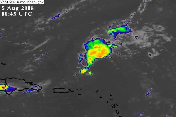
Honeyko wrote:Eyeball-projected 1930Z center-fix: just a sliver southeast of 22N/62W. WNW heading. SAL still to the east, barging it forward. Excellent southeast moist feed. More CB activity during diurnal minima than present last two days. Upper-trough to W-NW-N appears to be splitting apart into two ULLs, enabling 99L to pass between them into favorable region E of Bahamas.
Overnight diurnal maxima should be interesting.


Yes the next couple of days should be interesting for this one...
0 likes   

stevetampa33614

Re: ATL: Invest 99L in Central Atlantic

#745 Postby stevetampa33614 » Mon Aug 04, 2008 3:44 pm

Ive been watching hurricanes for quiet awhile. Im a bit confused and skeptical. How does the Sahara Air Layer 'push' a system a certain direction. I dont recall that ever happening anywhere, so Im somewhat skeptical
0 likes   

SapphireSea
Category 1
Category 1
Posts: 430
Joined: Wed Aug 24, 2005 12:13 pm
Location: Miami, FL

Re: ATL: Invest 99L in Central Atlantic

#746 Postby SapphireSea » Mon Aug 04, 2008 3:47 pm

I don't think SAL pushes any storms anywhere. It can inhibit developing storms and thus keep them steered by lower level flow, as opposed to a stronger system seeking higher level steering. The SAL's travel direction is based on low level winds, and this it can look like it's pushing a weak system. There is nothing really to it.
0 likes   

Honeyko

Re: ATL: Invest 99L in Central Atlantic

#747 Postby Honeyko » Mon Aug 04, 2008 4:23 pm

SapphireSea wrote:I don't think SAL pushes any storms anywhere.

Sure it can. Imagine it's analogous to a cold mass of air diving down the Great Plains: It'll affect the low-level currents of the warm air masses around it. To the SAL's south, surface westerlies develop, and to its west, southeasterlies.
0 likes   

User avatar
HURAKAN
Professional-Met
Professional-Met
Posts: 46086
Age: 38
Joined: Thu May 20, 2004 4:34 pm
Location: Key West, FL
Contact:

#748 Postby HURAKAN » Mon Aug 04, 2008 4:47 pm

Image

It may be shear-induced, but today is the first day in many days that convection is present throughout the day.
0 likes   

User avatar
kpost
Tropical Storm
Tropical Storm
Posts: 101
Age: 48
Joined: Sun Jul 06, 2008 10:52 am
Location: Indialantic, Florida (Ohio 4now)

Re: ATL: Invest 99L in Central Atlantic

#749 Postby kpost » Mon Aug 04, 2008 6:29 pm

It's like the little train that could.
Could anybody please answer my question from page 37 about the super warm waters of the Bahamas.
Thanks :P
0 likes   

stevetampa33614

Re: ATL: Invest 99L in Central Atlantic

#750 Postby stevetampa33614 » Mon Aug 04, 2008 7:11 pm

Well dolly limped across the atlantic like this. Now its over the bahama's with no recurve at all. So ya, gonna have to watch it now. Its bears some watching but I dont give a good chance the way its looking right now.

Im watching this more than Edouard, which is being way over hyped imo at this stage in development. Explosive development doesnt happen in early august ; its a slowed either strengthen or weaken type of thing.
Last edited by stevetampa33614 on Mon Aug 04, 2008 7:17 pm, edited 3 times in total.
0 likes   

stevetampa33614

Re: ATL: Invest 99L in Central Atlantic

#751 Postby stevetampa33614 » Mon Aug 04, 2008 7:12 pm

SapphireSea wrote:I don't think SAL pushes any storms anywhere. It can inhibit developing storms and thus keep them steered by lower level flow, as opposed to a stronger system seeking higher level steering. The SAL's travel direction is based on low level winds, and this it can look like it's pushing a weak system. There is nothing really to it.


See thats what im thinking. I just wanted a clarification. All these posters kept insisting it was.
0 likes   

stevetampa33614

Re: ATL: Invest 99L in Central Atlantic

#752 Postby stevetampa33614 » Mon Aug 04, 2008 7:15 pm

i apoligize it is not over the bahamas.
0 likes   

cpdaman
Category 5
Category 5
Posts: 3131
Joined: Sat Jun 10, 2006 11:44 am
Location: SPB county (gulf stream)

Re: ATL: Invest 99L in Central Atlantic

#753 Postby cpdaman » Mon Aug 04, 2008 7:29 pm

you can get rapid development in early august, what would stop a storm with low shear, moist air, over the NW carib. Nothing. less likely okay but can't is false.

anyhow looks like the base of the ULL is down around 21 north 63-65 W and

our friend appears to be approaching 63 or so west
http://cimss.ssec.wisc.edu/tropic/real- ... cjava.html


, should it gain another half a degree or so it would be in a less shear enviornment by morning

http://cimss.ssec.wisc.edu/tropic/real- ... g8shr.html

with about 10 mph or less , either way by morning it should be in a better enviornment as mid level shear drops off at 64 W.
0 likes   

User avatar
Blown Away
S2K Supporter
S2K Supporter
Posts: 10145
Joined: Wed May 26, 2004 6:17 am

Re: ATL: Invest 99L in Central Atlantic

#754 Postby Blown Away » Mon Aug 04, 2008 7:40 pm

The TAFB shows 99L as a low again in 24 hours, but opens it back up into a wave after that.
http://www.nhc.noaa.gov/tafb_latest/atl ... BW_sm3.gif
0 likes   

fasterdisaster
Category 5
Category 5
Posts: 1868
Joined: Mon Sep 19, 2005 4:41 pm
Location: Miami, Florida

#755 Postby fasterdisaster » Mon Aug 04, 2008 7:55 pm

I don't see why people suddenly are saying a recurve isn't going to happen. This pathetic excuse for a tropical wave is either going to stay a pathetic wave and then completely die from interaction with the Bahamas or it will develop into some cruddy little 40 mph TS and recurve into Greenland.
0 likes   

User avatar
cycloneye
Admin
Admin
Posts: 145308
Age: 68
Joined: Thu Oct 10, 2002 10:54 am
Location: San Juan, Puerto Rico

Re: ATL: Invest 99L in Central Atlantic

#756 Postby cycloneye » Mon Aug 04, 2008 7:57 pm

99L is still getting T numbers from ssd:

04/2345 UTC 21.7N 62.5W T1.0/1.0 99L -- Atlantic Ocean

http://www.ssd.noaa.gov/PS/TROP/positions.html
0 likes   

User avatar
HURAKAN
Professional-Met
Professional-Met
Posts: 46086
Age: 38
Joined: Thu May 20, 2004 4:34 pm
Location: Key West, FL
Contact:

#757 Postby HURAKAN » Mon Aug 04, 2008 8:09 pm

Image
0 likes   

User avatar
LSU2001
S2K Supporter
S2K Supporter
Posts: 1711
Age: 57
Joined: Sat Sep 11, 2004 11:01 pm
Location: Cut Off, Louisiana

Re: ATL: Invest 99L in Central Atlantic

#758 Postby LSU2001 » Mon Aug 04, 2008 8:14 pm

Not to compare at all but remember poor little TD10 in 2005. Dissipated then BAM. Developed into costliest cane in US history.
Tim
0 likes   

User avatar
Blown Away
S2K Supporter
S2K Supporter
Posts: 10145
Joined: Wed May 26, 2004 6:17 am

Re: ATL: Invest 99L in Central Atlantic

#759 Postby Blown Away » Mon Aug 04, 2008 8:19 pm

cycloneye wrote:99L is still getting T numbers from ssd:
04/2345 UTC 21.7N 62.5W T1.0/1.0 99L -- Atlantic Ocean
http://www.ssd.noaa.gov/PS/TROP/positions.html


Gotta love 99L, no matter what happens to 99L at this point it has been an emotional system to watch.
0 likes   

User avatar
Blown Away
S2K Supporter
S2K Supporter
Posts: 10145
Joined: Wed May 26, 2004 6:17 am

Re: ATL: Invest 99L in Central Atlantic

#760 Postby Blown Away » Mon Aug 04, 2008 8:23 pm

99L is back on a just N of due W track again.

Atlantic Ocean Basin: Imagery

DATE/TIME LAT LON CLASSIFICATION STORM
04/2345 UTC 21.7N 62.5W T1.0/1.0 99L
04/1745 UTC 28.2N 91.0W T3.0/3.0 EDOUARD
04/1745 UTC 21.6N 61.6W TOO WEAK 99L
04/1145 UTC 20.4N 59.0W TOO WEAK 99L
04/1145 UTC 28.3N 90.1W T2.5/2.5 EDOUARD
04/0545 UTC 19.8N 56.9W T1.0/1.0 99L
04/0545 UTC 28.2N 89.7W T2.0/2.0 EDOUARD
03/2345 UTC 28.1N 88.3W T2.0/2.0 EDOUARD
03/2345 UTC 19.4N 53.7W T1.0/1.0 99L
03/1745 UTC 28.4N 87.8W T1.5/1.5 91L
03/1745 UTC 19.4N 52.4W T1.0/1.0 99L
03/1145 UTC 28.2N 86.4W T1.5/1.5 91L
03/1145 UTC 18.7N 50.0W T1.0/1.0 99L
0 likes   


Return to “2008”

Who is online

Users browsing this forum: No registered users and 4 guests