cheezyWXguy wrote:You all cant be serious about the degeneration of this storm....it is doing no such thing. You cant really expect a storm to come out of land as perfectly as it went in. Even the nhc showed a slight weakening over land in cuba when this was at 125mph. This is wasting no time though. Reds now almost totally surround the eye, a quality this did NOT have consistently before landfall. You can see in just the last few frames even more convection developing. Tomorrow you all will wake up to a storm that is either strengthening or getting ready to strengthen. I am definitely predicting a cat5 tomorrow, assuming there is no unexpected shear or an ewrc.
ATL GUSTAV: Tropical Depression - Discussion
Moderator: S2k Moderators
Re: Cat. 4 Hurricane Gustav in Gulf of Mexico
There is a Cat 4 surge beginning to take route in the Gulf. It is pushing north. Even if....and this is only an 'if'...the winds are not as strong at landfall....as we learned from katrina which made landfall as a Cat 3 (weak Cat 4 around Buras?)...the surge does not diminish as fast. And this is not even taking into account a possible Cat 5 over the loop current.
0 likes
-
ConvergenceZone
.gif)
- Category 5

- Posts: 5241
- Joined: Fri Jul 29, 2005 1:40 am
- Location: Northern California
Re: Cat. 4 Hurricane Gustav in Gulf of Mexico
Click the link below for the latest discussion, just released
http://www.wunderground.com/tropical/at ... ml#a_topad
http://www.wunderground.com/tropical/at ... ml#a_topad
0 likes
Re: Cat. 4 Hurricane Gustav in Gulf of Mexico
soonertwister wrote:cheezyWXguy wrote:You all cant be serious about the degeneration of this storm....it is doing no such thing. You cant really expect a storm to come out of land as perfectly as it went in. Even the nhc showed a slight weakening over land in cuba when this was at 125mph. This is wasting no time though. Reds now almost totally surround the eye, a quality this did NOT have consistently before landfall. You can see in just the last few frames even more convection developing. Tomorrow you all will wake up to a storm that is either strengthening or getting ready to strengthen. I am definitely predicting a cat5 tomorrow, assuming there is no unexpected shear or an ewrc.
The pressure rose very little over Cuba. I wouldn't be shocked if Gustav went under 900 mb tomorrow.
Honestly, I think that prediction has no basis. Atmospheric conditions needs to be pretty much perfect for a hurricane to grow to that level of intensity. Gustav has the right water temperatures on his side, but not the upper-level wind conditions, which while okay, are not forecast to be anywhere close to that level of ideal.
0 likes
Re: Cat. 4 Hurricane Gustav in Gulf of Mexico
IMO nhc usually under forecasts intensity on eventual majors nearing cuba (24 hours out and more) and under forecasts weakening on the n. gulf coast (to play things safe i guess regarding final landfall)
not saying i would do better, but just a pattern i have seen
not saying i would do better, but just a pattern i have seen
0 likes
-
Weatherfreak000
-
soonertwister
- Category 5
- Posts: 1091
- Joined: Mon Jun 16, 2003 2:52 pm
Re: Cat. 4 Hurricane Gustav in Gulf of Mexico
The NHC has upped the wind estimate at landfall from 145 mph to 150. Just getting worser all the time.
I hate this storm.
I hate this storm.
0 likes
-
Just Joshing You

- Category 2

- Posts: 512
- Joined: Sat Nov 03, 2007 10:29 am
- Location: Nova Scotia
-
cheezyWXguy

- Category 5
- Posts: 6282
- Joined: Mon Feb 13, 2006 12:29 am
- Location: Dallas, TX
Re: Cat. 4 Hurricane Gustav in Gulf of Mexico
tallywx wrote:soonertwister wrote:cheezyWXguy wrote:You all cant be serious about the degeneration of this storm....it is doing no such thing. You cant really expect a storm to come out of land as perfectly as it went in. Even the nhc showed a slight weakening over land in cuba when this was at 125mph. This is wasting no time though. Reds now almost totally surround the eye, a quality this did NOT have consistently before landfall. You can see in just the last few frames even more convection developing. Tomorrow you all will wake up to a storm that is either strengthening or getting ready to strengthen. I am definitely predicting a cat5 tomorrow, assuming there is no unexpected shear or an ewrc.
The pressure rose very little over Cuba. I wouldn't be shocked if Gustav went under 900 mb tomorrow.
Honestly, I think that prediction has no basis. Atmospheric conditions needs to be pretty much perfect for a hurricane to grow to that level of intensity. Gustav has the right water temperatures on his side, but not the upper-level wind conditions, which while okay, are not forecast to be anywhere close to that level of ideal.
I dont see sub 900mb, seeing as that has only happened 5 times in history...conditions do not support it. But since this storm strengthened to 150mph under 20kt of shear, I cant see what would stop this storm from re intensifying to at least 160mph tomorrow.
0 likes
-
jasons2k

- Storm2k Executive

- Posts: 8290
- Age: 52
- Joined: Wed Jul 06, 2005 12:32 pm
- Location: The Woodlands, TX
Re: Cat. 4 Hurricane Gustav in Gulf of Mexico
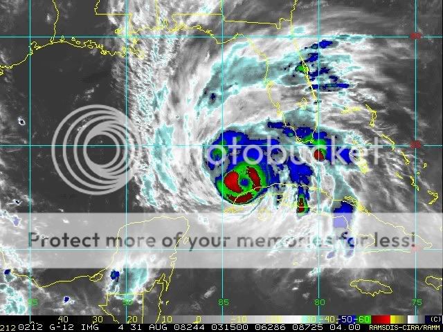
canetracker wrote:http://www.ssd.noaa.gov/goes/flt/t1/loop-avn.html
Geesh I am getting concerned. I have high elevation here but the winds are my fear.
IMO you need to pack-up your irreplaceables (pictures, etc.) and get out. NOW.
0 likes
-
ConvergenceZone
- Category 5
- Posts: 5241
- Joined: Fri Jul 29, 2005 1:40 am
- Location: Northern California
Re: Cat. 4 Hurricane Gustav in Gulf of Mexico
The latest discussion mentions just how problematic the intensity forecast is....In my opinion, if the shear and cooler water(after the loop current) gets the best of it, we can be looking at a storm as low as a cat 2 coming ashore. On the other hand, if the shear isn't as big of a problem, then a cat 4 is possible come landfall(just my opinion).... So.......it's hard to say what to expect unless someone has a crystal ball.
0 likes
-
GeneratorPower

- S2K Supporter

- Posts: 1648
- Age: 46
- Joined: Sun Dec 18, 2005 11:48 pm
- Location: Huntsville, AL
Re: Cat. 4 Hurricane Gustav in Gulf of Mexico
canetracker wrote:http://www.ssd.noaa.gov/goes/flt/t1/loop-avn.html
Geesh I am getting concerned. I have high elevation here but the winds are my fear.
You need to pack up and leave. You DO NOT want to be in New Orleans for the aftermath of this thing. Get out now.
0 likes
-
canetracker

- S2K Supporter
- Posts: 751
- Age: 63
- Joined: Wed Jul 27, 2005 8:49 pm
- Location: Suburbia New Orleans...Harahan, LA
Re: Cat. 4 Hurricane Gustav in Gulf of Mexico
jasons wrote:canetracker wrote:http://www.ssd.noaa.gov/goes/flt/t1/loop-avn.html
Geesh I am getting concerned. I have high elevation here but the winds are my fear.
IMO you need to pack-up your irreplaceables (pictures, etc.) and get out. NOW.
Thanks all, I am ready to move if needed. I am just numb over this situation and can't accept this is happening again.
0 likes
-
soonertwister
- Category 5
- Posts: 1091
- Joined: Mon Jun 16, 2003 2:52 pm
Re: Cat. 4 Hurricane Gustav in Gulf of Mexico
tallywx wrote:soonertwister wrote:cheezyWXguy wrote:You all cant be serious about the degeneration of this storm....it is doing no such thing. You cant really expect a storm to come out of land as perfectly as it went in. Even the nhc showed a slight weakening over land in cuba when this was at 125mph. This is wasting no time though. Reds now almost totally surround the eye, a quality this did NOT have consistently before landfall. You can see in just the last few frames even more convection developing. Tomorrow you all will wake up to a storm that is either strengthening or getting ready to strengthen. I am definitely predicting a cat5 tomorrow, assuming there is no unexpected shear or an ewrc.
The pressure rose very little over Cuba. I wouldn't be shocked if Gustav went under 900 mb tomorrow.
Honestly, I think that prediction has no basis. Atmospheric conditions needs to be pretty much perfect for a hurricane to grow to that level of intensity. Gustav has the right water temperatures on his side, but not the upper-level wind conditions, which while okay, are not forecast to be anywhere close to that level of ideal.
The hurricane hasn't reached the loop current yet. I don't think we can predict ultimate high intensity at this time. When Katrina hit the loop she went berzerk, with top winds at 150 knots and 902 mb. And that was from 110 knots before over open water. Let's see what happpens.
0 likes
Re:
Just Joshing You wrote:Hi, does anyone know of any good radar's for GRleve3? need to switch radar, image is starting to thin out.
The image is thinning out because the storm is thinning out. Right now, the eye is only 1.2 miles farther from the radar site than it was 1 1/2 hours ago.
0 likes
Re: Cat. 4 Hurricane Gustav in Gulf of Mexico
soonertwister wrote:The NHC has upped the wind estimate at landfall from 145 mph to 150. Just getting worser all the time.
I hate this storm.
we can only hope the intensity forecast is over done, but everyone must prepare like it is reality and leave IMO
0 likes
-
Lowpressure

- S2K Supporter
- Posts: 2032
- Age: 59
- Joined: Sun Sep 14, 2003 9:17 am
- Location: Charlotte, North Carolina

Re: Cat. 4 Hurricane Gustav in Gulf of Mexico
Somebody asked about landfall and proximity to Baton Rouge. . .Got me curious. Hope this helps:
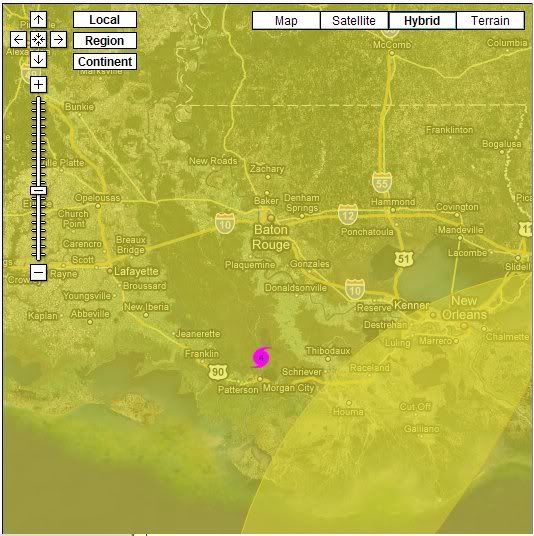
http://www.wunderground.com/wundermap/? ... &ft=0&sl=0
Joe (Bigsky770)
http://www.wunderground.com/wundermap/? ... &ft=0&sl=0
Joe (Bigsky770)
0 likes
-
CYCLONE MIKE
- Category 5
- Posts: 2183
- Joined: Tue Aug 31, 2004 6:04 pm
- Location: Gonzales, LA
One of the Baton Rouge local TV mets was just giving forecast for Baton Rouge during Gustav landfall. Says we (I live in parish southeast of BR) can expect 35-40 mph sustained winds with gusts approaching 60. Seems really low to me especially with the eastern eyewall passing so close. Does this sound right or wrong to anyone else?
0 likes


Who is online
Users browsing this forum: No registered users and 10 guests