ATL: Tropical Depression Fay
Moderator: S2k Moderators


-
Ground_Zero_92

- S2K Supporter

- Posts: 292
- Joined: Thu Sep 04, 2003 11:23 am
- Location: South Hutchinson Island / Stuart, FL
Re: ATL: Tropical Storm Fay South of Cuba
cpdaman wrote:eye balling a 320 degree NW motion for last hour per cuban radar, puts it now on the SW edge of convection.
Thats right cpdaman, it does look like it's moving NW. When I said that it was moving NW as it was aproaching the northern Cuban coast, about 1 - 1 1/2 hours ago, i was basically told that I was nuts.
Last edited by Ground_Zero_92 on Mon Aug 18, 2008 5:09 am, edited 1 time in total.
0 likes
-
Evil Jeremy

- S2K Supporter
- Posts: 5463
- Age: 32
- Joined: Mon Apr 10, 2006 2:10 pm
- Location: Los Angeles, CA
Re: ATL: Tropical Storm Fay South of Cuba
the SW side of her is getting eaten by a ULL the shear is pretty solid SSW erl'y ,perhaps the shear will lesten over next couple hours, who knows but right now i think only minimal lop sided strengthening may occur as she slides NW into open water as i type
0 likes
-
caneman
Re: ATL: Tropical Storm Fay South of Cuba
Ground_Zero_92 wrote:cpdaman wrote:eye balling a 320 degree NW motion for last hour per cuban radar, puts it now on the SW edge of convection.
Thats right cpdaman, it does look like it's moving NW. When I said that it was moving NW as it was coming off Cuba about 1 - 1 1/2 hours ago i was basically told that I was nuts.
You're not nuts. I just wasn't awake yet to help you confirm
SE Florida will still feel the effects though.
0 likes
Clipper96, its tough to say we may just be the MLC wrapping with the LLC displaced to the SW, remember when this was still an invest the MLC was wrapping even then as well.
Ground_Zero_92, it certainly looks like a NW track but want to see what it does in the next few hours as it slowly gets closer to the radar site.
Seems to me depsite the system getting neatly sheared the track of the LLC is likely around NNW.
Ground_Zero_92, it certainly looks like a NW track but want to see what it does in the next few hours as it slowly gets closer to the radar site.
Seems to me depsite the system getting neatly sheared the track of the LLC is likely around NNW.
0 likes
Re: ATL: Tropical Storm Fay South of Cuba
We really need to wait for visible to be able to identify how 'coupled' the system either is or isn't. If it re-stacks and slows over the straits... I wouldn't be suprised to see it get some of its act back together as that shear lessens slightly with the ULL slowly leaving the scene. It appears the energy, and potential is there for a strong TS to low cat1. I personally hope this doesn't turn into an ernesto... that storm really killed me. (it appears we are bound for MUCH more rain this time around)
-Eric
-Eric
0 likes
-
Cookiely

- S2K Supporter
- Posts: 3211
- Age: 75
- Joined: Fri Aug 13, 2004 7:31 am
- Location: Tampa, Florida
Re: ATL: Tropical Storm Fay South of Cuba
Someone should have gotten some sleep before writing this disco:
000
FXUS62 KTBW 180731
AFDTBW
AREA FORECAST DISCUSSION
NATIONAL WEATHER SERVICE TAMPA BAY RUSKIN FL
331 AM EDT MON AUG 18 2008
...SIGNIFICANT IMPACTS FROM FAY LIKELY TUESDAY AND WEDNESDAY...
.SHORT TERM (TODAY - WEDNESDAY)...TROPICAL STORM FAY NEAR THE SOUTH
COAST OF CUBA EARLY THIS MORNING IS EXPECTED TO MOVE NORTHWESTWARD
ACROSS THE ISLAND AND THEN TURN NORTHWARD. PLEASE SEE THE LATEST
DISCUSSIONS FROM THE NATIONAL HURRICANE CENTER FOR DETAILS. IT IS
IMPORTANT TO FOCUS ON THE CONE OF UNCERTAINTY THAT SURROUNDS THE
TRACK OF FAY. THE FORECAST WILL BEGIN TO DETERIORATE TONIGHT AND
THEN CONTINUE INTO WED WITH SIGNIFICANT TROPICAL CYCLONE IMPACTS.
THESE INCLUDE DAMAGING WINDS...HEAVY RAINFALL WITH POSSIBLE INLAND
FLOODING...AND POTENTIAL STORM SURGES.
.LONG TERM (WED NIGHT-SUN)...LITTLE CHANGE IN EXTENDED FORECAST.
OFFICIAL NHC TRACK OF TS FAY KEEPS STORM OVER NORTHERN FL PENINSULA
EARLY IN THE PERIOD...SO CAN STILL EXPECT TROPICAL STORM CONDITIONS
POSSIBLE N EARLY WED NT. FURTHER S CONDITIONS TO IMPROVE WITH SCT
RAIN CHANCES AS DEEP TROPICAL MOISTURE REMAINS OVER THE AREA.
RESIDUAL FLOODING PROBLEMS CONTINUE TO BE POSSIBLE.
THU-SUN...CONTINUE TO EXPECT WEAK SFC RIDGING OVER THE AREA FOR MORE
TYPICAL SUMMERTIME PATTERN OF SCATTERED AFTERNOON IN EVENING SHOWERS
AND THUNDERSTORMS. TEMPS TO HOLD AROUND NORMAL.
&&
Last edited by Cookiely on Mon Aug 18, 2008 5:13 am, edited 1 time in total.
0 likes

Re: ATL: Tropical Storm Fay South of Cuba
Any chance that we looking at the MLC again and the LLC is still inland and close to being on course.
0 likes
-
wxman57

- Moderator-Pro Met

- Posts: 23173
- Age: 68
- Joined: Sat Jun 21, 2003 8:06 pm
- Location: Houston, TX (southwest)
Re: ATL: Tropical Storm Fay South of Cuba
tailgater wrote:Any chance that we looking at the MLC again and the LLC is still inland and close to being on course.
Follow the convection. It doesn't matter where the LLC is if it's not under the convection. The convection is Fay, not any exposed swirl (if there was one). The center will follow the convection, not the other way around.
0 likes
-
Ground_Zero_92
- S2K Supporter
- Posts: 292
- Joined: Thu Sep 04, 2003 11:23 am
- Location: South Hutchinson Island / Stuart, FL
Re: ATL: Tropical Storm Fay South of Cuba
caneman wrote:Ground_Zero_92 wrote:cpdaman wrote:eye balling a 320 degree NW motion for last hour per cuban radar, puts it now on the SW edge of convection.
Thats right cpdaman, it does look like it's moving NW. When I said that it was moving NW as it was coming off Cuba about 1 - 1 1/2 hours ago i was basically told that I was nuts.
You're not nuts. I just wasn't awake yet to help you confirmIt's easy to get fooled by shear blow off though.
SE Florida will still feel the effects though.
No hard feelings.
0 likes
Re: ATL: Tropical Storm Fay South of Cuba
wxman57 wrote:tailgater wrote:Any chance that we looking at the MLC again and the LLC is still inland and close to being on course.
Follow the convection. It doesn't matter where the LLC is if it's not under the convection. The convection is Fay, not any exposed swirl (if there was one). The center will follow the convection, not the other way around.
Great way to put it... thanks for the re-inforcement of the idea in my head.
0 likes
-
Toyota Thundra
- Tropical Low

- Posts: 33
- Joined: Sat Aug 16, 2008 1:35 am
- Location: Riverview FL
Re: ATL: Tropical Storm Fay South of Cuba
G'd Morning Crew!  Im not quite awake yet so bear with me...
  I hear this talk of an eye wall, did she reach C1 before Cuban landfall? I only took a 5 hour nap, this is not where I thought she would be, but she is "The Alien of 08" and I guess she will act accordingly.
I turned on the news (Ch 08) and I had to laugh at the uncertainty portrayed by the forcaster. I dont think I have ever heard them say "The cone" So many times in one 2 minute block
 But anyway, she looks SO LOPSIDED right now, honestly what can we expect in tampa? Windy, squally.... due to the fact that there really is little to her W side ATM?
Josh
Im not quite awake yet so bear with me... I turned on the news (Ch 08) and I had to laugh at the uncertainty portrayed by the forcaster. I dont think I have ever heard them say "The cone" So many times in one 2 minute block
Josh
0 likes
Re: ATL: Tropical Storm Fay South of Cuba
Wind field spreading out nicely http://www.ndbc.noaa.gov/station_page.php?station=SMKF1, 31kt sustained 35 kt gust
0 likes
Re: ATL: Tropical Storm Fay South of Cuba
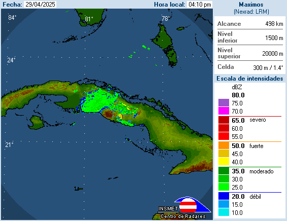
With the "center" still being a good distance from key west, plus the fact the radar is having to penetrate so much cloud cover that it is getting very incomplete pictures of the far side of the storm... it is somewhat helpful to view the cuban radar to see a clear side of the half of the storm. Albeit their radar leaves something to be desired.
For those that might not have it:
Cuban Radar http://www.insmet.cu/asp/genesis.asp?TB ... B1=RADARES
For those that might not have it:
Cuban Radar http://www.insmet.cu/asp/genesis.asp?TB ... B1=RADARES
0 likes

Re: ATL: Tropical Storm Fay South of Cuba
GFS doesn't really have this system moving inland over florida for almost 36 hours . . . if that ULL gets out of the way we could see some decent stregthening
0 likes
Who is online
Users browsing this forum: No registered users and 10 guests