

I would think the best thing to do is prepare for a system like this is to prepare for a category above. So in this case prepare for a top end category-1 and if you do that you won't be taken by surprise.
By the way does anyone have any radar images for this system?
ATL: Tropical Depression Edouard
Moderator: S2k Moderators


Re: ATL: Tropical Storm Edouard - Gulf of Mexico
Mecklenburg wrote:will this strengthen to hurricane status?
000
WTNT45 KNHC 032157
TCDAT5
TROPICAL STORM EDOUARD SPECIAL DISCUSSION NUMBER 2
NWS TPC/NATIONAL HURRICANE CENTER MIAMI FL AL052008
600 PM EDT SUN AUG 03 2008
WHEN THE RECONNAISSANCE AIRCRAFT PASSED THROUGH THE CONVECTION TO
THE SOUTHEAST OF THE CENTER A SHORT TIME AGO...IT FOUND MAXIMUM
FLIGHT LEVEL WINDS OF 54 KT AND A SURFACE PRESSURE OF 1002 MB...A
DROP OF 5 MB IN AN HOUR AND A HALF. THESE DATA INDICATE THAT THE
DEPRESSION HAS STRENGTHENED INTO THE FIFTH TROPICAL STORM OF THE
SEASON.
THIS SPECIAL ADVISORY UPDATES THE INITIAL AND FORECAST INTENSITY OF
THE TROPICAL CYCLONE. EDOUARD IS NOW EXPECTED TO BE NEAR HURRICANE
INTENSITY AT LANDFALL...WITH THE OFFICIAL FORECAST BETWEEN THE GFDL
AND SHIPS GUIDANCE.
FORECAST POSITIONS AND MAX WINDS
INITIAL 03/2200Z 28.1N 88.0W 40 KT
12HR VT 04/0600Z 28.2N 89.4W 45 KT
24HR VT 04/1800Z 28.4N 91.5W 50 KT
36HR VT 05/0600Z 28.9N 93.8W 60 KT
48HR VT 05/1800Z 29.5N 96.2W 45 KT...INLAND
72HR VT 06/1800Z 30.5N 100.5W 20 KT...REMNANT LOW
96HR VT 07/1800Z...DISSIPATED
$$
FORECASTER FRANKLIN/BLAKE
0 likes
-
HurricaneRobert
- Category 3

- Posts: 812
- Joined: Fri May 18, 2007 9:31 pm
Re: ATL: Tropical Storm Edouard - Gulf of Mexico
Humberto did present better than this at a lower intensity, but I wouldn't discount Edouard because of the real estate it has available.
0 likes
Re: ATL: Tropical Storm Edouard - Gulf of Mexico
stevetampa33614 wrote:MiamiensisWx wrote:stevetampa33614 wrote:Here is Wilma undergoing Extreme Intensification
That storm was so damn strong. 215mph gusts
http://www.youtube.com/watch?v=6OV9hFh64jE
Can we stop talking about Wilma? It's irrelevant, in my view.
Thanks!
geez i was just helping a guy find an image.
Yeah, we can't let the MAN hold us down dude!
That's the end of the Wilma chat.
0 likes
Mecklenburg, its certainly a possibility that needs watching, I'd guess probably a reasonable chance right now, esp if it can stay over water for another 36-48hrs like forecasted.
As for Humberto, it didn't really look all that stunning IMO till it was a hurricane but then it did look pretty classic.
As for Humberto, it didn't really look all that stunning IMO till it was a hurricane but then it did look pretty classic.
Last edited by KWT on Sun Aug 03, 2008 5:44 pm, edited 1 time in total.
0 likes
-
MiamiensisWx
Re: ATL: Tropical Storm Edouard - Gulf of Mexico
jordanmills wrote:MiamiensisWx wrote:jordanmills wrote:The "mandatory evacuation orders" are nuts, dude. Pretty soon they're going to start evacuating people for severe thunderstorms.
Do you have a family?
No, and you have a point. But I'd say that having a wife and a couple of kids over the age of two wouldn't change my thinking. Having a baby probably would.
Personally, based on my experience and concerns, I can't see how anyone should willingly ignore a mandatory evacuation order, but to each his own.
I'm very wary in regards to safety issues like this one, though I believe inland areas like Bay City should not require evacuations in this case.
0 likes
-
Just Joshing You

- Category 2

- Posts: 512
- Joined: Sat Nov 03, 2007 10:29 am
- Location: Nova Scotia


-
Honeyko
Re: ATL: Tropical Storm Edouard - Gulf of Mexico
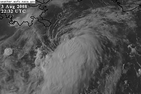
Edouard is still a slightly-decoupled system. There's a surface whorl just to the north of the convection, but if you look at waning-light visibles, you can see the northwesterly inflow jet coming in underneath the blow-off canopy, and a spiral of over-shooting CB tops leading up to the northernmost one. This implies, to me, that there's an 850mb center inside that northern cluster (which the plane may have missed if it was wave-hopping). As the evening bears on toward the diurnal maxima, one of two things will happen: Either the LLC is sucked completely under the 850mb, or the 850mb begins to orbit the LLC. (The first scenario is worse, because it yields are farther south storm.)
0 likes

Re: ATL: Tropical Storm Edouard - Gulf of Mexico
HurricaneRobert wrote:Humberto did present better than this at a lower intensity, but I wouldn't discount Edouard because of the real estate it has available.
Edouard will have more time on water though.
0 likes
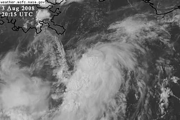
Still looks lop sided to me Hurakan but I suppose with the inflow from land into the northern quadrants that was always likely.
I wouldn't be expecting a nice system unless this gets upto the 75-85kts range then we probably will finally see this looking much better, I think it will continue to look less impressive then the wind speeds would show for the next 24hrs, after that then I'd expect real improvement as the shear totally eases off for good.
I wouldn't be expecting a nice system unless this gets upto the 75-85kts range then we probably will finally see this looking much better, I think it will continue to look less impressive then the wind speeds would show for the next 24hrs, after that then I'd expect real improvement as the shear totally eases off for good.
0 likes
-
Dionne

- S2K Supporter

- Posts: 1616
- Age: 74
- Joined: Mon Jan 02, 2006 8:51 am
- Location: SW Mississippi....Alaska transplant via a Southern Belle.
Re: ATL: Tropical Storm Edouard - Gulf of Mexico
Mecklenburg wrote:will this strengthen to hurricane status?
You can get advisories directly to your email from NHC. Just go to the site and sign up. Advisories coming out every two hours now they say.
0 likes

-
stevetampa33614
Re: ATL: Tropical Storm Edouard - Gulf of Mexico
MiamiensisWx wrote: Having a baby probably would.
Personally, based on my experience and concerns,[/quote][/quote]
Ya stupid idea, but then again when Charley was coming to Tampa and the State started ordering evacuations of Pinellas, Local mets on bay news 9 were telling people that the storm was going to headign further south and said to wait to be sure. Local mets saved alot of head aches.
Anyway. Im more worried about the rigs out there. What little domestic oil we are drilling is right in the path of edouard and strengthing would not be a good thing. Something like 4% of the worlds oil supply is in the Western GOM.
Praying to the Dry Air gods nothing close to a Cat 2.
Last edited by stevetampa33614 on Sun Aug 03, 2008 5:50 pm, edited 1 time in total.
0 likes
Re: ATL: Tropical Storm Edouard - Gulf of Mexico
njweather wrote:HurricaneRobert wrote:Humberto did present better than this at a lower intensity, but I wouldn't discount Edouard because of the real estate it has available.
Edouard will have more time on water though.
Yep it may have nearly as much time over water as Alicia did, though this one is a little closer to the coast but its also further east then Alicia as well.
0 likes
-
Just Joshing You
- Category 2
- Posts: 512
- Joined: Sat Nov 03, 2007 10:29 am
- Location: Nova Scotia
Who is online
Users browsing this forum: No registered users and 55 guests