ATL: Tropical Storm Kyle : Discussion

Moderator: S2k Moderators

Message
Author
User avatar
HURAKAN
Professional-Met
Professional-Met
Posts: 46086
Age: 38
Joined: Thu May 20, 2004 4:34 pm
Location: Key West, FL
Contact:

#841 Postby HURAKAN » Thu Sep 25, 2008 6:51 am

192
ABNT20 KNHC 251150
TWOAT
TROPICAL WEATHER OUTLOOK
NWS TPC/NATIONAL HURRICANE CENTER MIAMI FL
800 AM EDT THU SEP 25 2008

FOR THE NORTH ATLANTIC...CARIBBEAN SEA AND THE GULF OF MEXICO...

A WELL-DEFINED SURFACE LOW PRESSURE SYSTEM CENTERED ABOUT 180 MILES
SOUTHEAST OF THE SOUTH CAROLINA-NORTH CAROLINA BORDER IS MOVING
SLOWLY WESTWARD. SATELLITE IMAGES AND SURFACE OBSERVATIONS INDICATE
THAT THE LOW IS STILL EMBEDDED WITHIN A FRONTAL ZONE AND HAS NOT
YET ACQUIRED TROPICAL CHARACTERISTICS. HOWEVER THERE IS STILL A
POSSIBILITY THAT THIS SYSTEM COULD DEVELOP INTO A SUBTROPICAL OR
TROPICAL CYCLONE LATER TODAY. REGARDLESS OF WHETHER OR NOT THIS
OCCURS...STRONG WINDS...COASTAL FLOODING...HIGH SURF...AND
DANGEROUS RIP CURRENTS WILL CONTINUE ALONG PORTIONS OF THE U.S.
EAST COAST DURING THE NEXT COUPLE OF DAYS. INTERESTS ALONG THE U.S.
EAST COAST FROM SOUTH CAROLINA NORTHWARD TO THE MID-ATLANTIC REGION
SHOULD CLOSELY MONITOR STATEMENTS FROM THEIR LOCAL NATIONAL WEATHER
SERVICE FORECAST OFFICES...AND ALSO HIGH SEAS FORECASTS ISSUED BY
THE OCEAN PREDICTION CENTER FOR ADDITIONAL INFORMATION AND
WARNINGS.

:rarrow: A LOW PRESSURE SYSTEM CENTERED ABOUT 150 MILES EAST-NORTHEAST OF
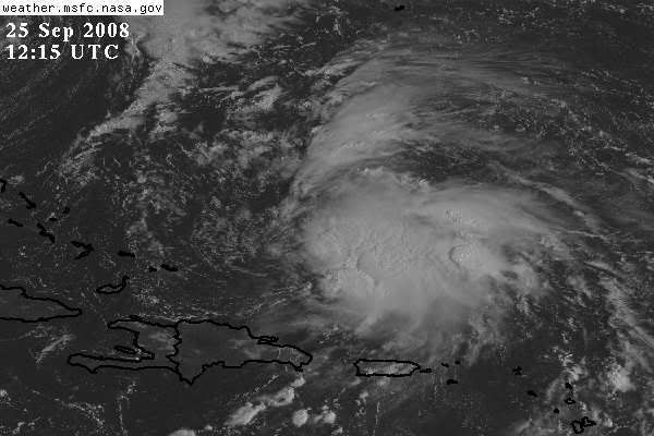
GRAND TURK ISLAND IS MOVING NORTHWARD AT 10 TO 15 MPH. SATELLITE
IMAGES INDICATE THAT THE SYSTEM IS NOT WELL ORGANIZED...WITH THE
LOW-LEVEL CIRCULATION CENTER DISPLACED TO THE WEST OF THE SHOWER
AND THUNDERSTORM ACTIVITY. UPPER-LEVEL WINDS COULD BRIEFLY BECOME
MORE CONDUCIVE FOR DEVELOPMENT AND THIS SYSTEM COULD BECOME A
TROPICAL CYCLONE OVER THE NEXT DAY OR SO.

ELSEWHERE...TROPICAL CYCLONE FORMATION IS NOT EXPECTED DURING THE
NEXT 48 HOURS.

$$
FORECASTER PASCH/ROBERTS
0 likes   

User avatar
HURAKAN
Professional-Met
Professional-Met
Posts: 46086
Age: 38
Joined: Thu May 20, 2004 4:34 pm
Location: Key West, FL
Contact:

#842 Postby HURAKAN » Thu Sep 25, 2008 6:55 am

Can anyone tell me when having the LLC displaced from the convection has been an impediment for upgrading a system?

Arlene? Alberto? Ana? Irene?

CONSISTENCY NHC, CONSISTENCY

I don't ask for anything more.
0 likes   

User avatar
AJC3
Admin
Admin
Posts: 3999
Age: 61
Joined: Tue Aug 31, 2004 7:04 pm
Location: Ballston Spa, New York
Contact:

Re:

#843 Postby AJC3 » Thu Sep 25, 2008 6:57 am

HURAKAN wrote:Can anyone tell me when having the LLC displaced from the convection has been an impediment for upgrading a system?

Arlene? Alberto? Ana? Irene?

CONSISTENCY NHC, CONSISTENCY

I don't ask for anything more.


stacy.stewart@noaa.gov
0 likes   

User avatar
HURAKAN
Professional-Met
Professional-Met
Posts: 46086
Age: 38
Joined: Thu May 20, 2004 4:34 pm
Location: Key West, FL
Contact:

#844 Postby HURAKAN » Thu Sep 25, 2008 6:57 am

Image

You got to be kidding me!
0 likes   

User avatar
HURAKAN
Professional-Met
Professional-Met
Posts: 46086
Age: 38
Joined: Thu May 20, 2004 4:34 pm
Location: Key West, FL
Contact:

Re: Re:

#845 Postby HURAKAN » Thu Sep 25, 2008 7:00 am

AJC3 wrote:
HURAKAN wrote:Can anyone tell me when having the LLC displaced from the convection has been an impediment for upgrading a system?

Arlene? Alberto? Ana? Irene?

CONSISTENCY NHC, CONSISTENCY

I don't ask for anything more.


stacy.stewart@noaa.gov


Thanks. E-mail sent! Lets see if they reply.
0 likes   

User avatar
HURAKAN
Professional-Met
Professional-Met
Posts: 46086
Age: 38
Joined: Thu May 20, 2004 4:34 pm
Location: Key West, FL
Contact:

#846 Postby HURAKAN » Thu Sep 25, 2008 7:04 am

Irene
Image

93L
Image

Which one is more exposed?
0 likes   

User avatar
bvigal
S2K Supporter
S2K Supporter
Posts: 2276
Joined: Sun Jul 24, 2005 8:49 am
Location: British Virgin Islands
Contact:

Re: ATL INVEST 93L: Discussion

#847 Postby bvigal » Thu Sep 25, 2008 7:07 am

Maybe they are just awaiting recon results?
0 likes   

User avatar
AJC3
Admin
Admin
Posts: 3999
Age: 61
Joined: Tue Aug 31, 2004 7:04 pm
Location: Ballston Spa, New York
Contact:

Re:

#848 Postby AJC3 » Thu Sep 25, 2008 7:14 am

HURAKAN wrote: Which one is more exposed?


This is where I get into a lot of disagreements with folks in here about what they consider inconsistency on the NHC's part, where I see actually see it as taking a consistently conservative tack.

What do I mean? Well, a static snapshot of two similar cyclones doesn't always tell the complete story. In Irene's case, it needs to be considered that it was already being carried operationally as a TC. With 93L, NHC has determined that they're going to wait a few more hours to see if the convection gets more centrally located before initating advisories.

So what I'm saying is that like it or not sometimes you'll get cases where a named system that is being carried operationally is held onto when it actually looks the same as (or in some cases, worse than) a system that is in the process of spinning up, but advisories aren't yet initiated on the latter system. NHC will hold onto the current status of a TC (non-system or invest) longer to make sure that the trend continues toward dissipation (development). They don't want to prematurely end (initiate) advisories only to have to restart (stop) them.
0 likes   

User avatar
HURAKAN
Professional-Met
Professional-Met
Posts: 46086
Age: 38
Joined: Thu May 20, 2004 4:34 pm
Location: Key West, FL
Contact:

Re:

#849 Postby HURAKAN » Thu Sep 25, 2008 7:15 am

HURAKAN wrote:TROPICAL WEATHER DISCUSSION
NWS TPC/NATIONAL HURRICANE CENTER MIAMI FL
805 AM EDT THU SEP 25 2008

A BROAD AREA OF LOW PRESSURE IS ANALYZED AS A 1005 MB LOW IS
JUST TO THE NE OF THE TURKS AND CAICOS NEAR 22N69W MOVING
NORTHWARD NEAR 10 KT. THIS SYSTEM HAS BECOME BETTER ORGANIZED
DURING THE PAST SEVERAL HOURS...AND UPPER-LEVEL WINDS ARE
EXPECTED TO GRADUALLY BECOME MORE FAVORABLE FOR A TROPICAL
DEPRESSION TO DEVELOP DURING THE NEXT DAY OR SO. THIS SYSTEM IS
BEING SHEARED BY THE DEEP LAYERED TROUGH TO THE W WITH SCATTERED
MODERATE/STRONG CONVECTION FROM 20N-24N BETWEEN 65W-68W AND
SCATTERED SHOWERS/ISOLATED THUNDERSTORMS OVER THE SW ATLC FROM
18N-26N BETWEEN 61W-70W INCLUDING ISLANDS THE VIRGIN ISLANDS...
PUERTO RICO AND HISPANIOLA.


TROPICAL WEATHER DISCUSSION...UPDATED
NWS TPC/NATIONAL HURRICANE CENTER MIAMI FL
805 AM EDT THU SEP 25 2008

A BROAD AREA OF LOW PRESSURE IS ANALYZED AS A 1005 MB LOW IS
JUST TO THE NE OF THE TURKS AND CAICOS NEAR 22N69W MOVING
NORTHWARD NEAR 10 KT. THIS SYSTEM IS NOT WELL ORGANIZED...WITH
THE LOW-LEVEL CIRCULATION CENTER DISPLACED TO THE WEST OF THE
SHOWER AND THUNDERSTORM ACTIVITY. UPPER-LEVEL WINDS COULD
BRIEFLY BECOME MORE CONDUCIVE FOR DEVELOPMENT AND THIS SYSTEM
COULD BECOME A TROPICAL CYCLONE OVER THE NEXT DAY OR SO.
THIS SYSTEM IS BEING SHEARED BY THE DEEP LAYERED TROUGH TO THE W
WITH SCATTERED MODERATE/STRONG CONVECTION FROM 20N-24N BETWEEN
65W-68W AND SCATTERED SHOWERS/ISOLATED THUNDERSTORMS OVER THE SW
ATLC FROM 18N-26N BETWEEN 61W-70W INCLUDING ISLANDS THE VIRGIN
ISLANDS... PUERTO RICO AND HISPANIOLA.

------------

Funny, they re-issued the TWD.
0 likes   

User avatar
wxman57
Moderator-Pro Met
Moderator-Pro Met
Posts: 22978
Age: 67
Joined: Sat Jun 21, 2003 8:06 pm
Location: Houston, TX (southwest)

Re:

#850 Postby wxman57 » Thu Sep 25, 2008 7:45 am

HURAKAN wrote:Can anyone tell me when having the LLC displaced from the convection has been an impediment for upgrading a system?
Arlene? Alberto? Ana? Irene?
CONSISTENCY NHC, CONSISTENCY
I don't ask for anything more.


I'm with you on the consistency thing, but there is a requirement that a TD/TS have a well-defined LLC. Satellite imagery only tells part of the story, you have to look at the surface to find an LLC. Even those low clouds you're seeing on satellite are several thousand feet above the surface. Surface obs are indicating E-ESE winds across the exposed center. The recent plot below has two ships reporting winds blowing away from the center. Can't find any reports south of the center, but it appears if there is any LLC it's very small and very weak. Not worthy of an upgrade to a TD without a better-defined LLC.

Image
0 likes   

User avatar
HURAKAN
Professional-Met
Professional-Met
Posts: 46086
Age: 38
Joined: Thu May 20, 2004 4:34 pm
Location: Key West, FL
Contact:

Re: ATL INVEST 93L: Discussion

#851 Postby HURAKAN » Thu Sep 25, 2008 7:46 am

Reply from James L. Franklin (NHC):

Dear Sandy,

The relationship between the circulation center and the deep
convection is one of several factors considered in the analysis of a
tropical cyclone or, in this case, a potential tropical cyclone. Our
operational definition of a tropical cyclone is "a warm-core non-
frontal synoptic-scale cyclone, originating over tropical or
subtropical waters, with organized deep convection and a closed
surface wind circulation about a well-defined center." The amount of
convective "organization" can be measured using the Dvorak technique.
We often take a Dvorak classification of T2.0 as representing
sufficient organization to initiate advisories on a tropical cyclone.
In the case of the disturbance this morning, the SAB classification
was T1.5, which is below our typical threshold.

Although we did not say so in the TWO this morning, initial reports
from a NOAA aircraft in the system (at 700 mb), as well as dropsonde
reports and satellite images, indicate that the circulation is highly
elongated and *may* still lack a well-defined center. Any additional
separation of the circulation from the convection would likely result
in further degradation of any center and a lowering of the Dvorak
classifications, which are already marginal for initiating
advisories. Further visible images this morning should clarify this
issue, as will as a low-level invest flight this afternoon.

I hope this helps.

Regards,

James
--
James L. Franklin

Senior Hurricane Specialist
National Hurricane Center
NOAA/NWS/Tropical Prediction Center
11691 SW 17th Street, Miami FL 33165
0 likes   

User avatar
wxman57
Moderator-Pro Met
Moderator-Pro Met
Posts: 22978
Age: 67
Joined: Sat Jun 21, 2003 8:06 pm
Location: Houston, TX (southwest)

Re: Re:

#852 Postby wxman57 » Thu Sep 25, 2008 7:47 am

HURAKAN wrote:
HURAKAN wrote:TROPICAL WEATHER DISCUSSION
NWS TPC/NATIONAL HURRICANE CENTER MIAMI FL
805 AM EDT THU SEP 25 2008

A BROAD AREA OF LOW PRESSURE IS ANALYZED AS A 1005 MB LOW IS
JUST TO THE NE OF THE TURKS AND CAICOS NEAR 22N69W MOVING
NORTHWARD NEAR 10 KT. THIS SYSTEM HAS BECOME BETTER ORGANIZED
DURING THE PAST SEVERAL HOURS...AND UPPER-LEVEL WINDS ARE
EXPECTED TO GRADUALLY BECOME MORE FAVORABLE FOR A TROPICAL
DEPRESSION TO DEVELOP DURING THE NEXT DAY OR SO. THIS SYSTEM IS
BEING SHEARED BY THE DEEP LAYERED TROUGH TO THE W WITH SCATTERED
MODERATE/STRONG CONVECTION FROM 20N-24N BETWEEN 65W-68W AND
SCATTERED SHOWERS/ISOLATED THUNDERSTORMS OVER THE SW ATLC FROM
18N-26N BETWEEN 61W-70W INCLUDING ISLANDS THE VIRGIN ISLANDS...
PUERTO RICO AND HISPANIOLA.


TROPICAL WEATHER DISCUSSION...UPDATED
NWS TPC/NATIONAL HURRICANE CENTER MIAMI FL
805 AM EDT THU SEP 25 2008

A BROAD AREA OF LOW PRESSURE IS ANALYZED AS A 1005 MB LOW IS
JUST TO THE NE OF THE TURKS AND CAICOS NEAR 22N69W MOVING
NORTHWARD NEAR 10 KT. THIS SYSTEM IS NOT WELL ORGANIZED...WITH
THE LOW-LEVEL CIRCULATION CENTER DISPLACED TO THE WEST OF THE
SHOWER AND THUNDERSTORM ACTIVITY. UPPER-LEVEL WINDS COULD
BRIEFLY BECOME MORE CONDUCIVE FOR DEVELOPMENT AND THIS SYSTEM
COULD BECOME A TROPICAL CYCLONE OVER THE NEXT DAY OR SO.
THIS SYSTEM IS BEING SHEARED BY THE DEEP LAYERED TROUGH TO THE W
WITH SCATTERED MODERATE/STRONG CONVECTION FROM 20N-24N BETWEEN
65W-68W AND SCATTERED SHOWERS/ISOLATED THUNDERSTORMS OVER THE SW
ATLC FROM 18N-26N BETWEEN 61W-70W INCLUDING ISLANDS THE VIRGIN
ISLANDS... PUERTO RICO AND HISPANIOLA.

------------

Funny, they re-issued the TWD.


The first one had most of yesterday's discussion in it about becoming better organized. New one says it's not well organized and shear is increasing.
0 likes   

User avatar
HURAKAN
Professional-Met
Professional-Met
Posts: 46086
Age: 38
Joined: Thu May 20, 2004 4:34 pm
Location: Key West, FL
Contact:

#853 Postby HURAKAN » Thu Sep 25, 2008 7:52 am

Image
0 likes   

User avatar
HURAKAN
Professional-Met
Professional-Met
Posts: 46086
Age: 38
Joined: Thu May 20, 2004 4:34 pm
Location: Key West, FL
Contact:

#854 Postby HURAKAN » Thu Sep 25, 2008 8:39 am

Loop: http://rammb.cira.colostate.edu/ramsdis ... _floater_1

The LLC looks very well-defined to me. Especially if you speed it up!
0 likes   

User avatar
HURAKAN
Professional-Met
Professional-Met
Posts: 46086
Age: 38
Joined: Thu May 20, 2004 4:34 pm
Location: Key West, FL
Contact:

Re: ATL INVEST 93L: Discussion

#855 Postby HURAKAN » Thu Sep 25, 2008 8:44 am

James L. Franklin wrote:The amount of
convective "organization" can be measured using the Dvorak technique.
We often take a Dvorak classification of T2.0 as representing
sufficient organization to initiate advisories on a tropical cyclone.
In the case of the disturbance this morning, the SAB classification
was T1.5, which is below our typical threshold.


25/1145 UTC 22.6N 68.5W T2.0/2.0 93L -- Atlantic Ocean

Classification please!! They probably don't like me very much in the NHC!!!
0 likes   

User avatar
HURAKAN
Professional-Met
Professional-Met
Posts: 46086
Age: 38
Joined: Thu May 20, 2004 4:34 pm
Location: Key West, FL
Contact:

#856 Postby HURAKAN » Thu Sep 25, 2008 8:54 am

Image
0 likes   

Ed Mahmoud

Re: Re:

#857 Postby Ed Mahmoud » Thu Sep 25, 2008 8:59 am

AJC3 wrote:
HURAKAN wrote:Can anyone tell me when having the LLC displaced from the convection has been an impediment for upgrading a system?

Arlene? Alberto? Ana? Irene?

CONSISTENCY NHC, CONSISTENCY

I don't ask for anything more.


stacy.stewart@noaa.gov


You don't think poor Mr. Stewart doesn't get enough e-mails from weather nerds like us?


Having said that, I did get a nice reply back from Lixion Avila once to an e-mail sent not to him, but to the general NHC contact e-mail.

I was going to save it forever, but new virus scan software being installed somehow killed all my saved e-mail.

I have a 'Maxtor' backup drive now, and automatically back up the computer everyday, so any further e-mails from NHC or Keith Olbermann (he is unhinged, BTW) will not be lost again.
0 likes   

User avatar
wxman57
Moderator-Pro Met
Moderator-Pro Met
Posts: 22978
Age: 67
Joined: Sat Jun 21, 2003 8:06 pm
Location: Houston, TX (southwest)

Re: ATL INVEST 93L: Discussion

#858 Postby wxman57 » Thu Sep 25, 2008 9:01 am

HURAKAN wrote:
James L. Franklin wrote:The amount of
convective "organization" can be measured using the Dvorak technique.
We often take a Dvorak classification of T2.0 as representing
sufficient organization to initiate advisories on a tropical cyclone.
In the case of the disturbance this morning, the SAB classification
was T1.5, which is below our typical threshold.


25/1145 UTC 22.6N 68.5W T2.0/2.0 93L -- Atlantic Ocean

Classification please!! They probably don't like very much in the NHC!!!


The LLC is still a bit questionable, certainly not well-defined. And it still lacks the organized deep convection:

"a warm-core non-
frontal synoptic-scale cyclone, originating over tropical or
subtropical waters, with organized deep convection and a closed
surface wind circulation about a well-defined center."
0 likes   

User avatar
fci
S2K Supporter
S2K Supporter
Posts: 3324
Joined: Tue Sep 14, 2004 10:29 am
Location: Lake Worth, FL

Re: Re:

#859 Postby fci » Thu Sep 25, 2008 9:48 am

Ed Mahmoud wrote:
AJC3 wrote:
HURAKAN wrote:Can anyone tell me when having the LLC displaced from the convection has been an impediment for upgrading a system?

Arlene? Alberto? Ana? Irene?

CONSISTENCY NHC, CONSISTENCY

I don't ask for anything more.


stacy.stewart@noaa.gov


You don't think poor Mr. Stewart doesn't get enough e-mails from weather nerds like us?


Having said that, I did get a nice reply back from Lixion Avila once to an e-mail sent not to him, but to the general NHC contact e-mail.

I was going to save it forever, but new virus scan software being installed somehow killed all my saved e-mail.

I have a 'Maxtor' backup drive now, and automatically back up the computer everyday, so any further e-mails from NHC or Keith Olbermann (he is unhinged, BTW) will not be lost again.


I'd say 46 minutes is a pretty quick reply from the NHC to sandy's question and the answer was good!!
Olberman is frightening. Funny.... but frightening. Especially how he gets people fired from MSNBC.
0 likes   

Sanibel
Category 5
Category 5
Posts: 10375
Joined: Mon Aug 30, 2004 11:06 pm
Location: Offshore SW Florida

Re: ATL INVEST 93L: Discussion

#860 Postby Sanibel » Thu Sep 25, 2008 9:48 am

Not buying it. Sustained surface wind from south at 46mph reported by ship is tropical storm no matter what the arguments. The Dvorak is also obviously better than 1.5
Last edited by Sanibel on Thu Sep 25, 2008 9:49 am, edited 1 time in total.
0 likes   


Return to “2008”

Who is online

Users browsing this forum: No registered users and 4 guests