This list is continuously being updated, but as of now:
(from KFDM)
Voluntary Evacuation and School Closings
There is a press release from Southeast Texas Emergency Management below all of the closings.
Closures as of 5:30AM Thursday, September 11th
College Closings:
* Lamar University - Beaumont Campus Closed Thursday and Friday
* LIT -Beaumont Campus Closed Thursday and Friday
* Lamar State College-Port Arthur Closing Thursday at noon and will remain closed through weekend
SCHOOL CLOSINGS:
* Port Neches-Groves ISD closed on Thursday and Friday
* High Island Schools closed Thursday and Friday
* Nederland ISD closed Thursday and Friday
* West Orange-Cove ISD closed Thursday and Friday
* Orangefield ISD closed Thursday and Friday
* Bridge City ISD closed Thursday and Friday
* Little Cypress-Mauriceville ISD closed Thursday and Friday
* Vidor ISD closed Thursday and Friday
* Hardin ISD (In Liberty County) closed Thursday and Friday
* Anahuac Schools are closed Thursday and Friday
* Hardin-Jefferson ISD closed Thursday and Friday
* The federal courthouse in downtown Beaumont will operate with a skeleton crew until Thursday at Noon and then close through Friday. The Jefferson County Courthouse will closed at noon on Thursday and remain closed Friday.
ATL: IKE Discussion
Moderator: S2k Moderators
-
southerngale

- Retired Staff

- Posts: 27418
- Joined: Thu Oct 10, 2002 1:27 am
- Location: Southeast Texas (Beaumont area)
-
Rod Hagen
- Tropical Storm

- Posts: 237
- Joined: Fri Sep 23, 2005 6:22 am
- Location: Lives in Melbourne, works in N Queensland
Re: Re:
Stormcenter wrote:
It's following the NHC's forecast points.
Well, not quite, Stormcenter.
At 5PM EDT the advisory for 12 hours on was 25.0N Actual position at 5AM EDT was 25.2N
At 11AM EDT the advisory for 12 hours onwards was 24.5N Actual position at 11PM was 24.9N
and so forth.
The latest "swing" does seem to have brought it back closer to the expected course, but prior to that there was a regular systematic difference it seemed to me.
0 likes

Re: ATL IKE: Category 2 - Discussion
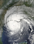
Wow, Ike is now really forming an eye!
Ike is looking far stronger on IR than ever before. Really intense convection and the pressure at 940/944 mbar is cat 3/cat 4 pressure. The wind west of the storm is fairly weak and doesn't extend far out, but a ship about 325 km ESE of New Orleans is reporting 60 kts sustained, I hope that's a mistake, thats 210 nm from Ike. edit: and 29.5 ft waves
Ike is looking far stronger on IR than ever before. Really intense convection and the pressure at 940/944 mbar is cat 3/cat 4 pressure. The wind west of the storm is fairly weak and doesn't extend far out, but a ship about 325 km ESE of New Orleans is reporting 60 kts sustained, I hope that's a mistake, thats 210 nm from Ike. edit: and 29.5 ft waves
Last edited by gubyw1 on Thu Sep 11, 2008 6:04 am, edited 1 time in total.
0 likes
-
Emmett_Brown

- Category 5

- Posts: 1433
- Joined: Wed Aug 24, 2005 9:10 pm
- Location: Sarasota FL
Re: Re:
Rod Hagen wrote:Stormcenter wrote:
It's following the NHC's forecast points.
Well, not quite, Stormcenter.
At 5PM EDT the advisory for 12 hours on was 25.0N Actual position at 5AM EDT was 25.2N
At 11AM EDT the advisory for 12 hours onwards was 24.5N Actual position at 11PM was 24.9N
and so forth.
The latest "swing" does seem to have brought it back closer to the expected course, but prior to that there was a regular systematic difference it seemed to me.
Perhaps even more significant, is that over the past 48 hours, Ike has been slower than forecast, which can have obvious impacts on track and timing. It looks like he is moving at a more steady pace now, but the last few frames still show intermittent pauses.
0 likes
Re: ATL IKE: Category 2 - Discussion
gubyw1 wrote:Wow, Ike is now really forming an eye!
Ike is looking far stronger on IR than ever before. Really intense convection and the pressure at 940/944 mbar is cat 3/cat 4 pressure. The wind west of the storm is fairly weak and doesn't extend far out, but a ship about 250 km ESE of New Orleans is reporting 60 kts sustained, I hope that's a mistake, thats 210 nm from Ike. edit: and 29.5 ft waves
that is not and eye, its a pocket of dry air watch loop and see.
0 likes

Re: ATL IKE: Category 2 - Discussion
dwg71 wrote:gubyw1 wrote:Wow, Ike is now really forming an eye!
Ike is looking far stronger on IR than ever before. Really intense convection and the pressure at 940/944 mbar is cat 3/cat 4 pressure. The wind west of the storm is fairly weak and doesn't extend far out, but a ship about 250 km ESE of New Orleans is reporting 60 kts sustained, I hope that's a mistake, thats 210 nm from Ike. edit: and 29.5 ft waves
that is not and eye, its a pocket of dry air watch loop and see.
Ah, ok, maybe not an eye, ship now reporting 62 kt winds 187 nm from Ike, 28.10 LAT, -86.30 LONG.
0 likes
-
southerngale
- Retired Staff
- Posts: 27418
- Joined: Thu Oct 10, 2002 1:27 am
- Location: Southeast Texas (Beaumont area)

No doubting Ike has a huge wind field.
This current track will be the worst of Ike right into Galveston and Houston. Right now Ikes double eyewall structure still has prevented any real strengthening but given the pressure if Ike's outer wall can totally take over then winds will ramp up in a very big way.
This current track will be the worst of Ike right into Galveston and Houston. Right now Ikes double eyewall structure still has prevented any real strengthening but given the pressure if Ike's outer wall can totally take over then winds will ramp up in a very big way.
0 likes
Re: ATL IKE: Category 2 - Discussion
Just announced that Orange and Jefferson Counties have ordered a mandatory evacuation at 6AM. Per KFDM TV.
0 likes
-
Portastorm

- Storm2k Moderator

- Posts: 9955
- Age: 63
- Joined: Fri Jul 11, 2003 9:16 am
- Location: Round Rock, TX
- Contact:
Re: ATL IKE: Category 2 - Discussion
You know, looking at the latest steering flow ... you almost wonder why Ike isn't moving northwest consistenly as compared to a flatter motion.
[img] [/img]
[img]
 [/img]
0 likes
Re: ATL IKE: Category 2 - Discussion
The double eyewall is about gone according to recon. There was a bit on the south side with the NOAA plane, but the latest pass by Air Force appears to show little. This will be an interesting pass going into the NE quadrant.
0 likes
-
Lowpressure

- S2K Supporter

- Posts: 2032
- Age: 59
- Joined: Sun Sep 14, 2003 9:17 am
- Location: Charlotte, North Carolina
Re: ATL IKE: Category 2 - Discussion
xironman-One would think that at some point the lower pressure will win out over concentric eyewalls. The wind almost has to catch up once that second wall is indeed gone.
Last edited by Lowpressure on Thu Sep 11, 2008 6:25 am, edited 3 times in total.
0 likes
So now its down to one eyewall, the outer one has taken over I presume?
I doubt there will be any weakening with Ike despite what the NHC said, as the outer eyewall is about as strong as the inner one was, in fact with one eyewall expect some strengthening as the energy finally concentrates into one eyewall...
Still got 48hrs or so till landfall as well, plenty of time...
0 likes

-
Sabanic

- Category 2

- Posts: 683
- Age: 66
- Joined: Wed Aug 01, 2007 7:01 am
- Location: Mobile, AL
- Contact:
Re:
KWT wrote:So now its down to one eyewall, the outer one has taken over I presume?
I doubt there will be any weakening with Ike despite what the NHC said, as the outer eyewall is about as strong as the inner one was, in fact with one eyewall expect some strengthening as the energy finally concentrates into one eyewall...
Still got 48hrs or so till landfall as well, plenty of time...
Closer to 60 hours if it were to make landfall close to Galveston
0 likes
-
Skintback26

- Tropical Wave

- Posts: 9
- Age: 61
- Joined: Sat Aug 27, 2005 4:56 pm
- Location: Lake Charles,Louisiana
- Contact:
-
Lowpressure
- S2K Supporter
- Posts: 2032
- Age: 59
- Joined: Sun Sep 14, 2003 9:17 am
- Location: Charlotte, North Carolina
Re:
[quote="rockyman"]View from my deck...Sunrise along Bienville River, I mean Bienville Blvd (Dauphin Island, Alabama):
This may be a stupid question, but is that rainfall or surge?
This may be a stupid question, but is that rainfall or surge?
0 likes
Yeah Sabanic, the problem is even if this landfalls a little bit down the coast, The Houston/Galveston area is still going to get hammered quite hard, just got to hope the eyewall doesn't hit, with such a big region of hurricane force winds even when the system is still over water they will probably feeling hurricane winds possibly even near Houston.
0 likes
-
Hurricanewatcher2007

- Category 2
- Posts: 578
- Joined: Sat Jul 05, 2008 8:10 pm

Who is online
Users browsing this forum: No registered users and 26 guests